14G; The Sandersville Limestone
Member of the Tobacco Road Sand
by
Henry N. Josey, PharmD.
Filed October 18, 2017
Updated August 21, 2018
The Sandersville Limestone Member is small geologic unit restricted to Washington, Jefferson, and Burke Counties in east central Georgia. It is the basal unit of the Tobacco Road Sand Formation and dates to the Upper Eocene, Priabonian (Upper Jacksonian), about 33.9 million years old. It is abundantly fossiliferous with a great variety of both invertebrate and vertebrate fossils.
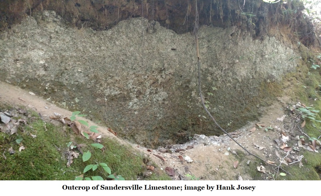
Historically, the Sandersville Limestone has been well studied. Veatch and Stephenson (1911) described it as part of the McBean Formation and remarked about the abundance of “lime biscuits” found in the area (fossils of the late Eocene sand dollar Periarchus quinquefarius kewi). Analysis of the limestone by Brantley (1916) showed that it is a pure limestone, being 92 – 93% pure calcium carbonate. Cooke and Shearer (1918) moved it to the Barnwell Formation. Huddlestun and Hetrick (1986) assigned it as the Sandersville Limestone Member, a basal unit of the Tobacco Road Sand Formation.
Outside of east central Georgia, it grades into the Tobacco Road Sand. It is underlain by the Dry Branch Formation (Twiggs Clay and Irwinton Sand facies) and is overlain by the Tobacco Road Sand Formation and the Altamaha Formation. According to Huddlestun and Hetrick, the Sandersville Member is a limestone offshore facies of the Tobacco Road Sand. Based on their observations, it has a maximum thickness of 19 feet.
Outside of east central Georgia, it grades into the Tobacco Road Sand. It is underlain by the Dry Branch Formation (Twiggs Clay and Irwinton Sand facies) and is overlain by the Tobacco Road Sand Formation and the Altamaha Formation. According to Huddlestun and Hetrick, the Sandersville Member is a limestone offshore facies of the Tobacco Road Sand. Based on their observations, it has a maximum thickness of 19 feet.
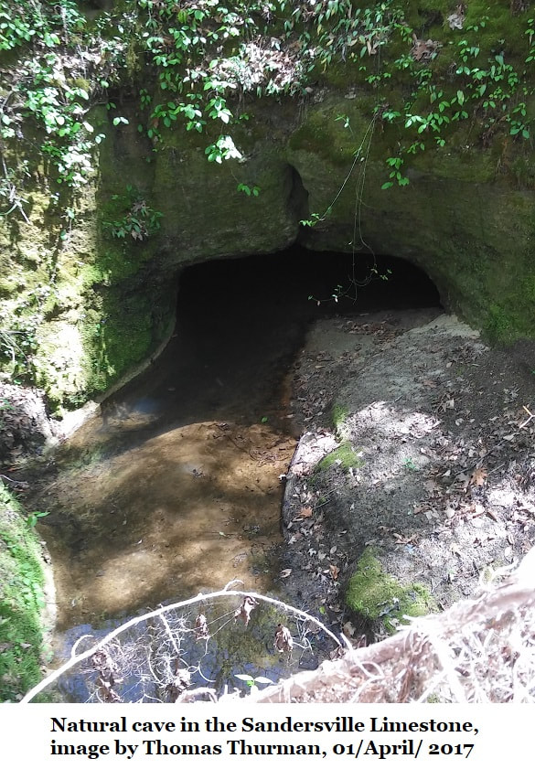
The area around central Washington County is abundant with sinkholes, resulting from the dissolution of the soft Sandersville Limestone by groundwater. As the limestone is dissolved, the space created collapses under the weight of the overlying material. The ground beneath Sandersville is riddled with caves and passages, some extending for almost a mile. Sinkholes led to closure of several streets in 1923. In the 1930s, a local barn was also swallowed by a sinkhole.
Veatch and Stephenson also described an extremely fossiliferous outcrop at Old Towne in southeastern Jefferson County. Additional outcrops have been identified around Brier Creek in southern Burke County.
Veatch and Stephenson also described an extremely fossiliferous outcrop at Old Towne in southeastern Jefferson County. Additional outcrops have been identified around Brier Creek in southern Burke County.
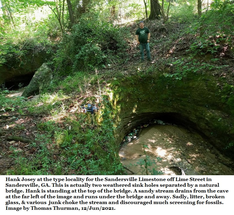
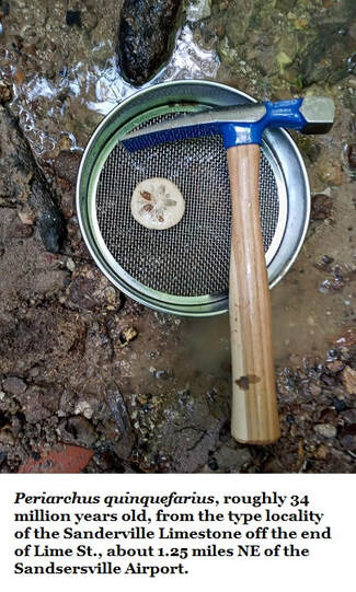
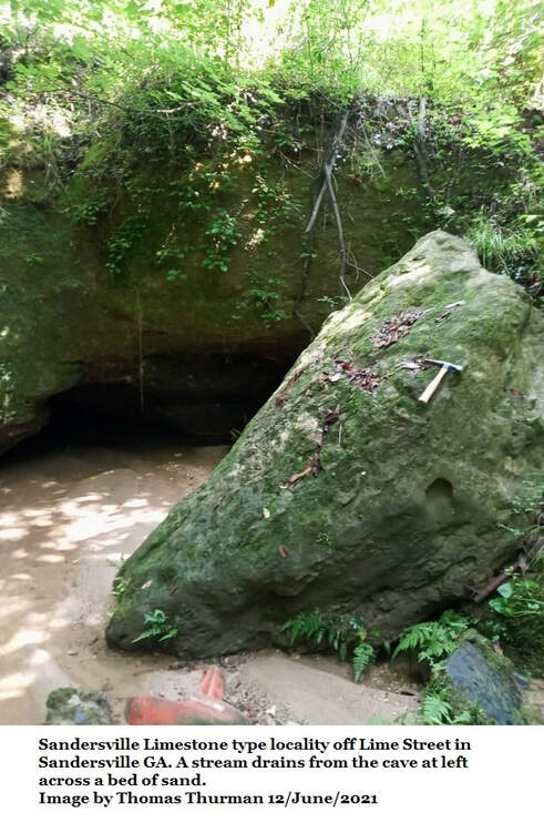
The type locality is in a small sinkhole located at the end of Lime Street in Sandersville at N 32o 58.365’, W 82o 48.924’, roughly 0.8 miles south of the Washington County court house. When the author visited this locality in October 2016, the area was severely blighted and the lime sink and the creek feeding it were choked full of garbage, old tires, and refuse (the author advises extreme caution as this neighborhood is very unsafe). Fortunately, recent utility work by the city exposed numerous specimens of Periarchus quinquefarius kewi and the author collected a shoebox full in an hour. These specimens had worn free of the surrounding limestone matrix and were remarkably well preserved, requiring only light cleaning with a Dremel tool.
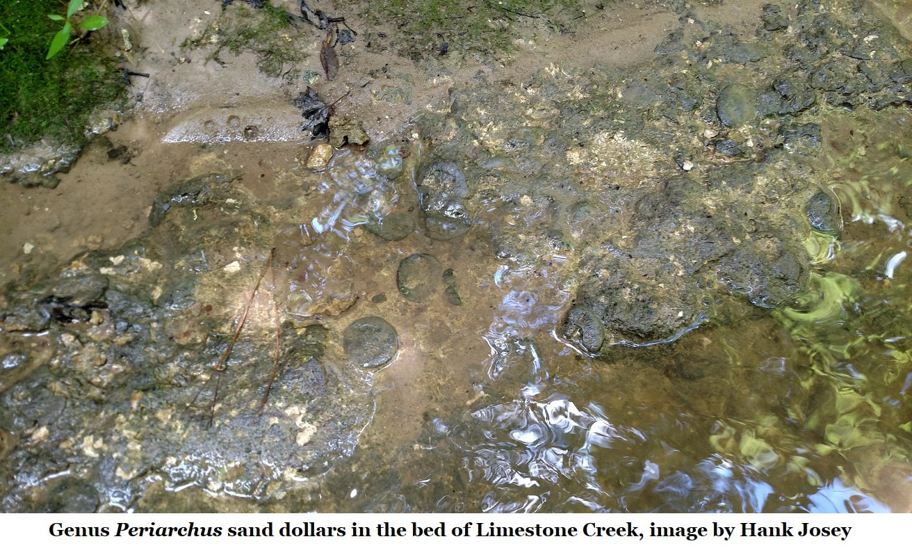
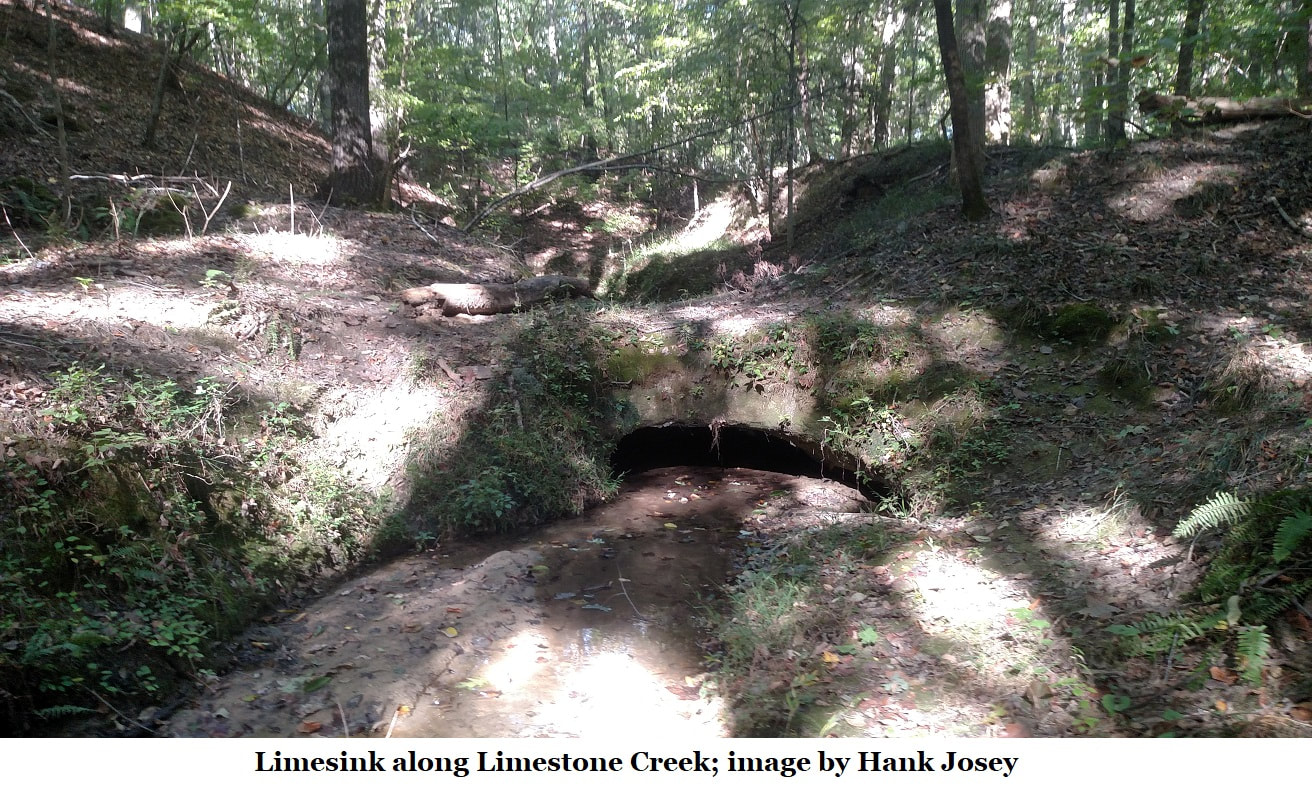
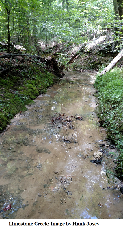
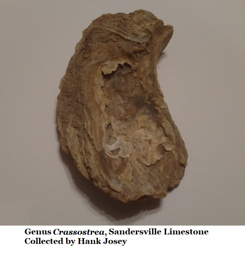
Additional outcrops are visible in the lime sinks south of Sandersville near Tennille. In the bed of Limestone Creek on Industrial Road, approximately 0.5 miles south of Kaolin Road, the Sandersville Limestone is visible, including an extensive bed of Periarchus quinquefarius kewi in living positions. The top of the unit is visible in a road cut at the location with multiple specimens of Crassostrea gigantissima. These are silicified and few are whole. They are not nearly as large as specimens of the same species from Griffin’s Landing on the Savannah River.
The following list, drawn from a review of the literature and from the author’s personal research collection, describes the species know from the Sandersville Limestone.
Vertebrate
Aetobatis (Spotted eagle ray)
Basilosaurus (Toothed whale)
Carcharias (Sand tiger shark)
Carcharocles auriculatus (Megatooth shark)
Crocodilidae indet (Undetermined crocodile)
Galeocerdo latidans (Tiger shark)
Myliobatis (Eagle ray)
Negaprion eurybathrodon (Lemon shark)
Serratolamna lerichei (Mackerel shark)
Sirenian (Protosirenidae or Prorastomidae)
Sphyraena (Barracuda)
Teleost (otoliths and dorsal spines; Bony fish)
Invertebrate
Balanus (Acorn barnacle)
Calyptrea aperta
Caricella pryuloides
Chlamys (Scallop)
Corbula alabamiensis
Corbula densata
Crassatellites altus
Crassatellites protextus
Crassostrea gigantissima (Giant oyster)
Cytherea perovata
Dentalium (Tusk shell)
Endopachys maclurii (Solitary coral)
Flabellum cuneiforme
Glycemeris idomea (Clam)
Glycemeris staminea
Glycemeris trigonella (Clam)
Leda multilineata
Lunulite distans (Bryozoa)
Lunulite jacksonensis (Bryozoa)
Mesalia vetusta
Mitra
Nucula ovula
Periarchus quinquefarius kewi (Sand dollar)
Phalum
Platytrochus stokesi
Spisula praetenuis
Turritella carinata (marine snail)
Venericardia alticostata
References
Brantley, J. E. A Report on the Limestones and Marls of the Coastal Plain of Georgia. Bulletin 21. Georgia Geologic Survey. The Blosser Company: Atlanta, GA. 1916.
Cooke, C. W. and H. K. Shearer Deposits of Claiborne and Jackson Age in Georgia. Professional Paper 120 - C. US Geologic Survey. Government Printing Office: Washington, DC. 1918.
Cooke, C. W. Cenozoic Echinoids of the Eastern United States. Professional Paper 321 US Geologic Survey. US Government Printing Office: Washington, DC. 1959.
Cooke, C. W. Geology of the Coastal Plain of Georgia. Bulletin 941 US Geologic Survey. US Government Printing Office, Washington, DC. 1943.
Gore, P. J. and W. Witherspoon. Roadside Geology of Georgia. Mountain Press Publishing Company: Missoula, MT. 2013.
Germano, J. The Sandersville Limestone: a Study of Depositional Environment. 2000. http://jrscience.wcp.miamioh.edu/evol00/FinalArticles/Final1TheSandersvilleLime.html
Huddlestun, P. F. and J. H. Hetrick. Stratigraphy of the Tobacco Road Sand – A New Formation. Georgia Department of Natural Resources: Atlanta, GA. 1978.
Huddlestun, P. F. and J. H. Hetrick. Upper Eocene Stratigraphy of Central and Eastern Georgia. Bulletin 95 Georgia Geologic Survey. GA Department of Natural Resources: Atlanta, GA. 1986.
Richards, H. G. Illustrated Fossils of the Georgia Coastal Plain. Georgia Mineral Newsletter. 1969.
Smith, W. H. Geology of the Tennille Lime Sinks Washington County, Georgia. Budget Publications: Sandersville, GA. 1983.
Thurman, T. “Dating Late Eocene Sediments.” GeorgiasFossils.com. http://www.georgiasfossils.com/13h-dating-late-eocene-sediments.html
Veatch, O. V and W. L. Stephenson. Preliminary Report on the Geology of the Coastal Plain of Georgia. Bulletin 26 Geological Survey of Georgia. Foote & Davies: Atlanta, GA. 1911.