25D: Transcription of the
1976 Physiographic Map
of Georgia
By Thomas Thurman
Posted 30/March/2022
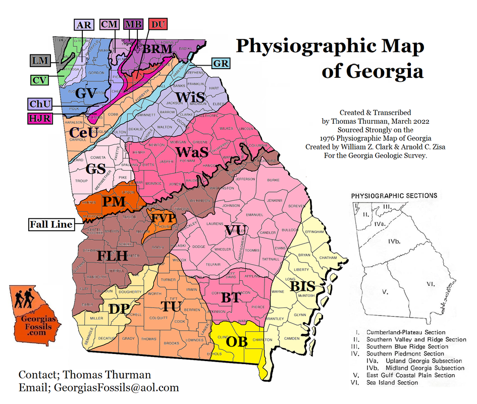
The original 1976 physiographic map was created by William Z. Clark and Arnold C. Zisa, while Sam Pickering was State Geologist, and was intended as a guide to the 1976 Georgia Geologic Map. An attempt has been made here to unify the information from both maps.
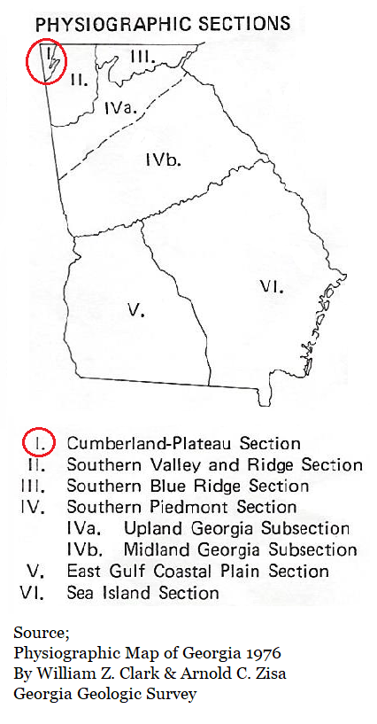
APPALACHIAN HIGHLANDS MAJOR DIVISION
APPALACHIAN PLATEAU PROVINCE
Cumberland Plateau Section

LM; Lookout Mountain District
The Lookout Mountain District is composed of two nearly flat-topped mountains, lookout-pigeon and Sand Mountain, separated by Lookout Valley which is a breached anticline. The mountains are capped by Rockcastle Sandstone of Pennsylvanian age and the valley is underlain my Chickamauga Limestone of Ordovician age. The upland slopes gently to the southwest from a maximum elevation of 2200 feet near Durham to an elevation of 2000 feet near the Alabama-Georgia border. The northwestern margin of Lookout Mountain and the southeastern margin of Sand Mountain are marked by a continuous escarpment that drops abruptly 1000-1200 feet to Lookout Valley. Elevations in Lookout Valley vary from 800-1000 feet. The escarpment on the southeastern side of Lookout-Pigeon Mountain, the district and province boundary, drops abruptly 800-1000 feet to the Chickamauga Valley District. These escarpments are breached by numerous small streams which have their source of the upland and reach the valleys through deep notches in the cliffs.
The Lookout Mountain District is composed of two nearly flat-topped mountains, lookout-pigeon and Sand Mountain, separated by Lookout Valley which is a breached anticline. The mountains are capped by Rockcastle Sandstone of Pennsylvanian age and the valley is underlain my Chickamauga Limestone of Ordovician age. The upland slopes gently to the southwest from a maximum elevation of 2200 feet near Durham to an elevation of 2000 feet near the Alabama-Georgia border. The northwestern margin of Lookout Mountain and the southeastern margin of Sand Mountain are marked by a continuous escarpment that drops abruptly 1000-1200 feet to Lookout Valley. Elevations in Lookout Valley vary from 800-1000 feet. The escarpment on the southeastern side of Lookout-Pigeon Mountain, the district and province boundary, drops abruptly 800-1000 feet to the Chickamauga Valley District. These escarpments are breached by numerous small streams which have their source of the upland and reach the valleys through deep notches in the cliffs.
RIDGE AND VALLEY PROVINCE
Southern Valley and Ridge Section
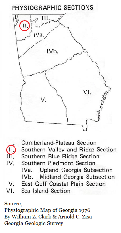

CV; Chickamauga Valley District
The Chickamauga Valley District is characterized by a series of gently rolling, discontinuous north-east-trending valleys interrupted by low, linear, parallel ridges. The valley floors are predominately limestone and dolomite of Cambro-Ordovician age while the ridges are capped by the more resistant cherty units of the Knox Group, also of Cambro-Ordovician age. The ridge tops are approximately 1000 feet in elevation and stand 200 to 300 feet above the intervening valleys. Rectangular drainage patterns in this district are indicative of structural control.
The Chickamauga Valley District is characterized by a series of gently rolling, discontinuous north-east-trending valleys interrupted by low, linear, parallel ridges. The valley floors are predominately limestone and dolomite of Cambro-Ordovician age while the ridges are capped by the more resistant cherty units of the Knox Group, also of Cambro-Ordovician age. The ridge tops are approximately 1000 feet in elevation and stand 200 to 300 feet above the intervening valleys. Rectangular drainage patterns in this district are indicative of structural control.

AR; Armuchee Ridge District
A series of prominent, narrow, chevron shaped ridges dominate the Armuchee Ridge District. These ridges rise abruptly 600-700 feet above the Chickamauga Valley District to the northwest and the Great Valley District to the south and east. This southern and eastern boundary closely parallels the Rome Fault. These ridges, predominantly by Red Mountain sandstone of Silurian age, stand at elevations of 1400-1600 feet. Intervening valley floors are generally underlain by shales and limestones of Mississippian and Cambro-Ordovician age, respectively.
A series of prominent, narrow, chevron shaped ridges dominate the Armuchee Ridge District. These ridges rise abruptly 600-700 feet above the Chickamauga Valley District to the northwest and the Great Valley District to the south and east. This southern and eastern boundary closely parallels the Rome Fault. These ridges, predominantly by Red Mountain sandstone of Silurian age, stand at elevations of 1400-1600 feet. Intervening valley floors are generally underlain by shales and limestones of Mississippian and Cambro-Ordovician age, respectively.

GV; The Great Valley District
The Great Valley District is typically broad and open with a few scattered ridges and hills. Elevations throughout the area range from 700-800 feet above sea level with relief of 50 to 100 feet. The floor of the valley is underlain by shales, dolomites and limestones of Cambrian and Ordovician age. The eastern boundary of the Great Valley follows the escarpment of the Great Smoky-Cartersville Fault.
The Great Valley District is typically broad and open with a few scattered ridges and hills. Elevations throughout the area range from 700-800 feet above sea level with relief of 50 to 100 feet. The floor of the valley is underlain by shales, dolomites and limestones of Cambrian and Ordovician age. The eastern boundary of the Great Valley follows the escarpment of the Great Smoky-Cartersville Fault.
BLUE RIDGE PROVINCE
Southern Blue Ridge Section
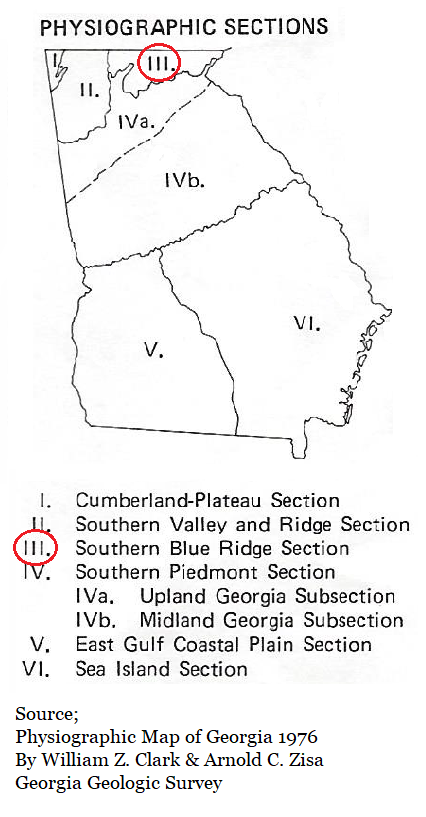

CM; Cohutta Mountains District
An irregular mass of rugged mountains ranging in elevation from 3000-4000 feet is characteristic of the Cohutta Mountains District. Erosion of metamorphosed sediments of the Ocoee series by the headwater tributaries of southwestward and northward flowing streams has produced valleys 1000-1500 feet below the mountain crests. The southern boundary of this district slopes steeply to the lower elevations of the Cherokee Uplands District. In Georgia the Cohutta Mountains are separated from the main body of the Blue Ridge by the McCaysville Basin and the Jasper Ridges.
An irregular mass of rugged mountains ranging in elevation from 3000-4000 feet is characteristic of the Cohutta Mountains District. Erosion of metamorphosed sediments of the Ocoee series by the headwater tributaries of southwestward and northward flowing streams has produced valleys 1000-1500 feet below the mountain crests. The southern boundary of this district slopes steeply to the lower elevations of the Cherokee Uplands District. In Georgia the Cohutta Mountains are separated from the main body of the Blue Ridge by the McCaysville Basin and the Jasper Ridges.

MB; McCaysville Basin District
Mountains almost completely enclose the McCaysville Basin District and rise from the 2000 foot elevation at the edge of the basin to heights of 4000-4500 feet above sea level. This topographic basin is bisected by the northeast trending Jasper Ridges; however, the topography on both sides of these ridges is remarkable similar. The gently rolling topography, produced by the erosion of the Great Smoky Group, varies in elevation from 1600 to 1800 feet. Relief throughout the Basin varies from 200-300 feet except along the northwest-flowing stream valleys and near the Jasper Ridges where it varies from 300 to 500 feet.
Mountains almost completely enclose the McCaysville Basin District and rise from the 2000 foot elevation at the edge of the basin to heights of 4000-4500 feet above sea level. This topographic basin is bisected by the northeast trending Jasper Ridges; however, the topography on both sides of these ridges is remarkable similar. The gently rolling topography, produced by the erosion of the Great Smoky Group, varies in elevation from 1600 to 1800 feet. Relief throughout the Basin varies from 200-300 feet except along the northwest-flowing stream valleys and near the Jasper Ridges where it varies from 300 to 500 feet.

BRM; Blue Ridge Mountains District
A mass of rugged mountains and ridges ranging in elevation from 3500-4700 feet in the north and east to 3000-3500 feet in the southwest is the dominant topographic feature of the Blue Ridge Mountain District. Differing rates of erosion upon the Great Smoky Group by the headwater tributary streams, that eventually drain to either the Atlantic Ocean or the Gulf of Mexico, have produced valleys that are 1500-2000 feet below the adjacent summits. The southern boundary of the Blue Ridge abuts the Piedmont Province at approximately the 1700 foot elevation where a sharp change in regional slope occurs.
A mass of rugged mountains and ridges ranging in elevation from 3500-4700 feet in the north and east to 3000-3500 feet in the southwest is the dominant topographic feature of the Blue Ridge Mountain District. Differing rates of erosion upon the Great Smoky Group by the headwater tributary streams, that eventually drain to either the Atlantic Ocean or the Gulf of Mexico, have produced valleys that are 1500-2000 feet below the adjacent summits. The southern boundary of the Blue Ridge abuts the Piedmont Province at approximately the 1700 foot elevation where a sharp change in regional slope occurs.
PIEDMONT PROVINCE
Southern Piedmont Section
Upland Georgia Subsection
Upland Georgia Subsection
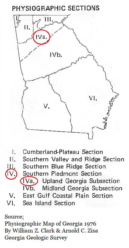

ChU; Cherokee Upland District
The northern portion of the Cherokee Upland District is a rough, hilly surface with elevations ranging from 1300-1500 feet. Except for a few isolated mountains. elevation gradually decrease to 1000 feet in the southern part. The westward-flowing streams in the northern area occupy deep, narrow valleys300-600 feet below the adjacent ridges. The eastern and southern boundaries are formed by the low, linear, parallel ridges of the Hightower-Jasper Ridges District.
The northern portion of the Cherokee Upland District is a rough, hilly surface with elevations ranging from 1300-1500 feet. Except for a few isolated mountains. elevation gradually decrease to 1000 feet in the southern part. The westward-flowing streams in the northern area occupy deep, narrow valleys300-600 feet below the adjacent ridges. The eastern and southern boundaries are formed by the low, linear, parallel ridges of the Hightower-Jasper Ridges District.

DU; Dahlonega Upland District
The rough and hilly northeastern part of the Dahlonega Upland District stands 1500-1700 feet above sea level. Streams in the area flow south out of the Blue Ridge Mountains District, and have cut deep, narrow valleys 500-600 feet below the surrounding surface. In the southern and southwestern portions, surface elevations decrease to 1200 feet. Stream valleys are wider, more open, and only 200-300 feet below the adjacent surface. The southern and western boundaries are formed by the low linear, parallel ridges of the Hightower-Jasper Ridges District.
The rough and hilly northeastern part of the Dahlonega Upland District stands 1500-1700 feet above sea level. Streams in the area flow south out of the Blue Ridge Mountains District, and have cut deep, narrow valleys 500-600 feet below the surrounding surface. In the southern and southwestern portions, surface elevations decrease to 1200 feet. Stream valleys are wider, more open, and only 200-300 feet below the adjacent surface. The southern and western boundaries are formed by the low linear, parallel ridges of the Hightower-Jasper Ridges District.

HJR; Hightower-Jasper Ridges District
Although Hightower Ridges and Jasper Ridges have different structural and lithologic histories, they are topographically so similar that they must be discussed together. The Hightower-Jasper Ridges District consists of a series of low, linear, parallel ridges separated by narrow valleys. The Hightower Ridges range in elevations from 1500 feet in the northeast to 1000 feet on the southwest. Relief in this area varies from 500 feet in the northeast to 200 feet in the southwest. The Jasper Ridges bisect the McCaysville Basin District and continue southward as allow area between the Cohutta and Blue Ridge Mountains. These ridges range in elevation from 2400 feet in the north to 1200 feet near Canton where they join the Hightower Ridges. Relief varies from 800 feet in the north to 200 feet near Lake Allatoona. Some structural control of streams in the district is exhibited by the modified rectangular drainage patterns. The southern and western boundaries are located where there is a decrease in the density of the linear ridges.
Although Hightower Ridges and Jasper Ridges have different structural and lithologic histories, they are topographically so similar that they must be discussed together. The Hightower-Jasper Ridges District consists of a series of low, linear, parallel ridges separated by narrow valleys. The Hightower Ridges range in elevations from 1500 feet in the northeast to 1000 feet on the southwest. Relief in this area varies from 500 feet in the northeast to 200 feet in the southwest. The Jasper Ridges bisect the McCaysville Basin District and continue southward as allow area between the Cohutta and Blue Ridge Mountains. These ridges range in elevation from 2400 feet in the north to 1200 feet near Canton where they join the Hightower Ridges. Relief varies from 800 feet in the north to 200 feet near Lake Allatoona. Some structural control of streams in the district is exhibited by the modified rectangular drainage patterns. The southern and western boundaries are located where there is a decrease in the density of the linear ridges.

CeU; Central Uplands District
The northeastern and central portions of the Central Upland District area series of low, linear ridges 1300-1500 feet above sea level, and separated by broad, open valleys. Streams flowing through this section are generally traverse to the structure and occupy valleys 1150-200 feet below the ridge crests. In the southwestern part, elevations decrease to 1100 feet, and the linearity of the topography is not so apparent. Stream valleys in the southwestern portion are not as open as those to the northeast. They exhibit a rectangular drainage pattern and lie only 100-150 feet below the surrounding area. The southern boundary of this district is the ridge crest that marks the beginning of the Gainesville Ridges District.
The northeastern and central portions of the Central Upland District area series of low, linear ridges 1300-1500 feet above sea level, and separated by broad, open valleys. Streams flowing through this section are generally traverse to the structure and occupy valleys 1150-200 feet below the ridge crests. In the southwestern part, elevations decrease to 1100 feet, and the linearity of the topography is not so apparent. Stream valleys in the southwestern portion are not as open as those to the northeast. They exhibit a rectangular drainage pattern and lie only 100-150 feet below the surrounding area. The southern boundary of this district is the ridge crest that marks the beginning of the Gainesville Ridges District.

GR; Gainesville Ridges District
A series of northeast-trending, low, linear, parallel ridges separated by narrow valleys characterizes the Gainesville Ridge District. The ridges are composed of quartzite and gneiss, while the valleys are underlain by phyllonite and schist. These ridges vary in elevation from 1500-1600 feet in the northeast and decrease gradually to 700 feet in the southwest. Relief varies from 100-200 feet in the northeast to 70-100 feet in the southwest. The courses of the Chattahoochee River and its tributaries are strongly controlled by the ridges in this district and exhibit a good example of rectangular drainage. The southern boundary follows a ridge that is continuous throughout most of it extent decreasing in elevation from 1100 feet in the northeast to 700 feet in the southwest. This ridge crest is the drainage divide between southwest flowing streams and those streams draining to the south.
A series of northeast-trending, low, linear, parallel ridges separated by narrow valleys characterizes the Gainesville Ridge District. The ridges are composed of quartzite and gneiss, while the valleys are underlain by phyllonite and schist. These ridges vary in elevation from 1500-1600 feet in the northeast and decrease gradually to 700 feet in the southwest. Relief varies from 100-200 feet in the northeast to 70-100 feet in the southwest. The courses of the Chattahoochee River and its tributaries are strongly controlled by the ridges in this district and exhibit a good example of rectangular drainage. The southern boundary follows a ridge that is continuous throughout most of it extent decreasing in elevation from 1100 feet in the northeast to 700 feet in the southwest. This ridge crest is the drainage divide between southwest flowing streams and those streams draining to the south.
Midland Georgia Subsection
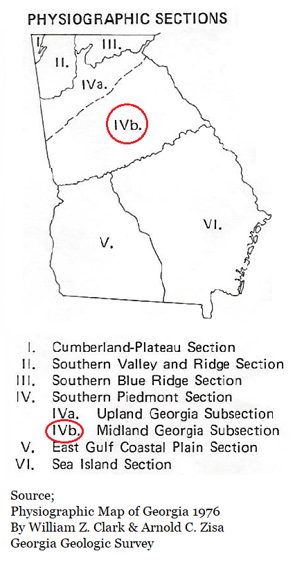

WiS; Winder Slope District
The gently rolling topography of the Winder Slope District slopes gradually from an elevation of 1000 feet in the north to 700 feet at the southern edge. This district is dissected by the headwater tributaries of the major streams draining to the Atlantic Ocean. Numerous dome-shaped, granitic mountains are located on the interfluves in the southern and western portion of this district. (Interfluve; a region between the valleys of adjacent watercourses, especially in a dissected upland.) The stream valleys which are fairly deep and narrow; lie 100-200 feet below the narrow, rounded stream divides. The western boundary follows the drainage divide that separates streams draining to the Atlantic Ocean from those draining to the Gulf of Mexico. The southern boundary approximates the 700 foot elevation where a sharp break in regional slope occurs.
The gently rolling topography of the Winder Slope District slopes gradually from an elevation of 1000 feet in the north to 700 feet at the southern edge. This district is dissected by the headwater tributaries of the major streams draining to the Atlantic Ocean. Numerous dome-shaped, granitic mountains are located on the interfluves in the southern and western portion of this district. (Interfluve; a region between the valleys of adjacent watercourses, especially in a dissected upland.) The stream valleys which are fairly deep and narrow; lie 100-200 feet below the narrow, rounded stream divides. The western boundary follows the drainage divide that separates streams draining to the Atlantic Ocean from those draining to the Gulf of Mexico. The southern boundary approximates the 700 foot elevation where a sharp break in regional slope occurs.

WaS; Washington Slope District
The Washington Slope District is characterized by a gently undulating surface which descends gradually from about the 700 foot elevation at the northern margin to about the 500 foot elevation at its southern edge. Streams occupy broad, shallow valleys with long, gentle side slopes separated by broad, rounded divides. Relief throughout this district is 50-100 feet except in the vicinity of the Ocmulgee, which flows in a steep walled valley 150-200 feet below the adjacent area. The western boundary corresponds to the drainage divide between the Atlantic Ocean and the Gulf of Mexico. They southern boundary, known as the Fall Line, follows the contact between the metamorphic rocks of the Piedmont and the sediments of the Coastal Plain.
The Washington Slope District is characterized by a gently undulating surface which descends gradually from about the 700 foot elevation at the northern margin to about the 500 foot elevation at its southern edge. Streams occupy broad, shallow valleys with long, gentle side slopes separated by broad, rounded divides. Relief throughout this district is 50-100 feet except in the vicinity of the Ocmulgee, which flows in a steep walled valley 150-200 feet below the adjacent area. The western boundary corresponds to the drainage divide between the Atlantic Ocean and the Gulf of Mexico. They southern boundary, known as the Fall Line, follows the contact between the metamorphic rocks of the Piedmont and the sediments of the Coastal Plain.

GS; Greenville Slope District
The Greenville Slope District is characterized by rolling topography that decreases gradually in elevation from 1000 feet in the northeast to 600 feet in the southwest. All streams in this district eventually drain to the Gulf of Mexico. However, those flowing to the southwest occupy shallow, open valleys with broad, rounded divides while those flowing to the southeast occupy narrower, deeper valleys with narrow, rounded divides. Relief varies from 150-200 feet in the east and 100-150 feet in the west. The southern boundary follows the base of the northern side of Pine Mountain, which rises abrupt 250-400 feet above the adjacent surface.
The Greenville Slope District is characterized by rolling topography that decreases gradually in elevation from 1000 feet in the northeast to 600 feet in the southwest. All streams in this district eventually drain to the Gulf of Mexico. However, those flowing to the southwest occupy shallow, open valleys with broad, rounded divides while those flowing to the southeast occupy narrower, deeper valleys with narrow, rounded divides. Relief varies from 150-200 feet in the east and 100-150 feet in the west. The southern boundary follows the base of the northern side of Pine Mountain, which rises abrupt 250-400 feet above the adjacent surface.

PM; Pine Mountain District
The portion of this district known as Pine-Oak Mountain has a lenticular form extending from the Alabama border to near Barnesville. Quartzite caps Pine-Oak Mountain and the adjacent ridges. These ridges rise abruptly from the Greenville Slop District to elevations of 1200-1300 feet. In the eastern part of Pine Mountain, the Flint River has cut a deep, narrow gorge some 300-400 feet below the summit. South of the Pine-Oak Mountain portion of this district, the surface slopes gently from 800 feet elevation to approximately 500 feet at its southern edge. Relief is this portion generally varies from 50-100 feet. The southern boundary, known as the Fall Line, follows the contact between metamorphic rocks of the Peidmont and the sediments of the Coastal Plain.
The portion of this district known as Pine-Oak Mountain has a lenticular form extending from the Alabama border to near Barnesville. Quartzite caps Pine-Oak Mountain and the adjacent ridges. These ridges rise abruptly from the Greenville Slop District to elevations of 1200-1300 feet. In the eastern part of Pine Mountain, the Flint River has cut a deep, narrow gorge some 300-400 feet below the summit. South of the Pine-Oak Mountain portion of this district, the surface slopes gently from 800 feet elevation to approximately 500 feet at its southern edge. Relief is this portion generally varies from 50-100 feet. The southern boundary, known as the Fall Line, follows the contact between metamorphic rocks of the Peidmont and the sediments of the Coastal Plain.
ATLANTIC PLAIN MAJOR DIVISION
COASTAL PLAIN PROVINCE
COASTAL PLAIN PROVINCE
Sea Island and East Gulf Coastal Plain Section

FLH; Fall Line Hill District
The Fall Line is the northern boundary of this district as well as the boundary between the Atlantic Plain and the Appalachian Highlands Major Divisions. Geologically, it is the contact between the Cretaceous and younger sediments of the Coastal Plain and the older crystalline rocks of the Piedmont. Several stream characteristics change as they flow through this area: rapids and shoals are common near the geologic contact, floodplains are considerably wider on the younger sediments and the frequency of stream meanders increases.
The southern boundary of the Fall Lines Hill District approximates the 250 foot elevation and separates this district from the Dougherty Plain. Eastward, the southern boundary follows the northern extremity of the Pelham Escarpment separating the Fall Line Hills from the Tifton Upland. The southern boundary then closely follows the northmost occurrence of the undifferentiated Neogene geologic unit which underlies the Vidalia Upland.
The Fall Line Hill District is highly dissected with little level land except for marshy floodplains and their narrow, better drained stream terraces, Stream valleys lie 50 to 250 feet below the adjacent ridge tops, Stream dissection seems to be greatest in the East Gulf portion of this district. Relief gradually diminishes to the south and east. Maximum elevations are approximately 750 feet between Columbus and Macon and gradually diminish to a minimum elevation of 150 feet south of Augusta.

FVP; Fort Valley Plateau District
An anomalous area within the Fall Line Hills is known as the Fort Valley Plateau. It is Characterized by flat-topped interfluves with narrow, 50-150 feet deep, steep walled valleys. (Interfluve; a region of higher land between two rivers or creeks that are in the same drainage system.) This area is distinct from the Fall Line Hills in that the broad, flat topped interfluves are the dominant feature, there are fewer streams, and there is less local relief. The area is less dissected than the Fall Line Hills because it is underlain by the more clayey units of the undifferentiated Eocene, Paleocene and possibly Cretaceous age sediments. Elevations range from 550 feet in the north to 250 feet in the southeast, indicating a southeast regional dip. The east and west boundaries are the Ocmulgee and Flint River Valleys, respectively. The southern boundary is formed by Hogcrawl and Big Indian Creeks. The northern boundary occurs at approximately the 500 foot elevation where the narrow, steep interfluves of the Fall Line Hills abruptly change to the lower, flat-topped interfluves of the Fort Valley Plateau.
An anomalous area within the Fall Line Hills is known as the Fort Valley Plateau. It is Characterized by flat-topped interfluves with narrow, 50-150 feet deep, steep walled valleys. (Interfluve; a region of higher land between two rivers or creeks that are in the same drainage system.) This area is distinct from the Fall Line Hills in that the broad, flat topped interfluves are the dominant feature, there are fewer streams, and there is less local relief. The area is less dissected than the Fall Line Hills because it is underlain by the more clayey units of the undifferentiated Eocene, Paleocene and possibly Cretaceous age sediments. Elevations range from 550 feet in the north to 250 feet in the southeast, indicating a southeast regional dip. The east and west boundaries are the Ocmulgee and Flint River Valleys, respectively. The southern boundary is formed by Hogcrawl and Big Indian Creeks. The northern boundary occurs at approximately the 500 foot elevation where the narrow, steep interfluves of the Fall Line Hills abruptly change to the lower, flat-topped interfluves of the Fort Valley Plateau.
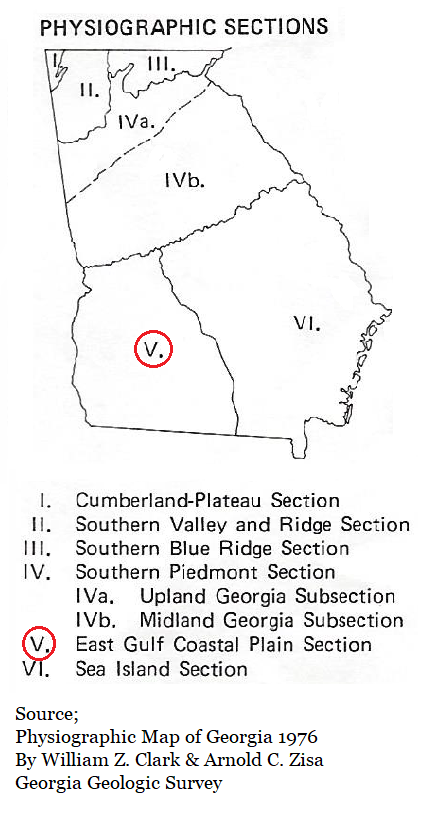
East Gulf Coastal Plain Section

DP; Dougherty Plain District
The Dougherty Plain is a northeast trending, wedge-shaped, level to gently rolling lowland that pinches out where the Fall Line Hills and the Tifton Uplift meet. The northwestern boundary is gradational from the Fall Line Hills and occurs where the slopes become more gentle and the relief is low; the 250 foot elevation approximates this boundary. The Southeastern boundary is the base of the Pelham Escarpment which separates this district from the Tifton Upland. The region slopes southwestward with maximum elevations of 300 feet in the northeast to a minimum elevation of 77 feet at Lake Seminole. The flat to very gently rolling topography is interrupted by numerous sinkholes. Karst topography prevails in this district. (Karst is a type of landscape where the dissolving of the bedrock has created sinkholes, sinking streams, caves, springs, and other characteristic features.) Many sinkholes, still actively forming, are the sites of numerous ponds and marshes. The karst topography is formed on the underlying Ocala and Suwannee Limestones of Eocene and Oligocene age, respectively.
The Dougherty Plain is a northeast trending, wedge-shaped, level to gently rolling lowland that pinches out where the Fall Line Hills and the Tifton Uplift meet. The northwestern boundary is gradational from the Fall Line Hills and occurs where the slopes become more gentle and the relief is low; the 250 foot elevation approximates this boundary. The Southeastern boundary is the base of the Pelham Escarpment which separates this district from the Tifton Upland. The region slopes southwestward with maximum elevations of 300 feet in the northeast to a minimum elevation of 77 feet at Lake Seminole. The flat to very gently rolling topography is interrupted by numerous sinkholes. Karst topography prevails in this district. (Karst is a type of landscape where the dissolving of the bedrock has created sinkholes, sinking streams, caves, springs, and other characteristic features.) Many sinkholes, still actively forming, are the sites of numerous ponds and marshes. The karst topography is formed on the underlying Ocala and Suwannee Limestones of Eocene and Oligocene age, respectively.

TU; Tifton Upland District
A well developed, extended, dendritic drainage pattern is formed on the undifferentiated Neogene sediments in the Tifton Upland District. Characteristically, the interfluves are narrow and rounded, rising 250 to 200 feet above the narrow valley floors. Elevations range from 480 feet in the north to 150 feet in the southeast indicating regional slope. The northwestern and northern boundary is the base of the Pelham Escarpment which rises as much as 200 feet above the Dougherty Plain. The eastern boundary follows the eastern drainage divide of the Alapaha River.
A well developed, extended, dendritic drainage pattern is formed on the undifferentiated Neogene sediments in the Tifton Upland District. Characteristically, the interfluves are narrow and rounded, rising 250 to 200 feet above the narrow valley floors. Elevations range from 480 feet in the north to 150 feet in the southeast indicating regional slope. The northwestern and northern boundary is the base of the Pelham Escarpment which rises as much as 200 feet above the Dougherty Plain. The eastern boundary follows the eastern drainage divide of the Alapaha River.
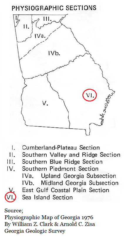
Sea Island Section

VU; Vidalia Upland District
The Vidalia Upland District is a moderately dissected area with a well-developed dendritic stream pattern on gravelly, clayey sands. (Dendritic; branching like a tree.) Floodplains are narrow except along the principal rivers which have a wide expanse of swamp bordering both sides of the channel. Relief varies from 100 to 150 feet. Elevations in the district range from 500 feet in the northwest to 100 feet in the southeast indicating regional dip. The northern and northwestern boundary approximates the northernmost occurrence of the undifferentiated Neogene geologic unit. The southwestern and southern boundary is the base of the Pelham Escarpment and the southern drainage divide of the Altamaha River. The southeastern boundary follows the Orangeburg Escarpment at approximately the 150 foot elevation. The escarpment rises 50-70 feet above the Barrier Island Sequence District.
The Vidalia Upland District is a moderately dissected area with a well-developed dendritic stream pattern on gravelly, clayey sands. (Dendritic; branching like a tree.) Floodplains are narrow except along the principal rivers which have a wide expanse of swamp bordering both sides of the channel. Relief varies from 100 to 150 feet. Elevations in the district range from 500 feet in the northwest to 100 feet in the southeast indicating regional dip. The northern and northwestern boundary approximates the northernmost occurrence of the undifferentiated Neogene geologic unit. The southwestern and southern boundary is the base of the Pelham Escarpment and the southern drainage divide of the Altamaha River. The southeastern boundary follows the Orangeburg Escarpment at approximately the 150 foot elevation. The escarpment rises 50-70 feet above the Barrier Island Sequence District.

BT; Bacon Terraces District
Several moderately dissected terraces, generally parallel to the present coastline, are detectable on topographic maps of the Bacon Terraces District. However, they are very difficult to observe on the ground because the east facing scarps are very subtle. The terraces levels occur at elevations of 330-310 feet, 295-275 feet, 265-255 feet, 240 feet, 230 feet, 215-190 feet, and 180-160 feet. This district, on the north, west, and south, corresponds to the Satilla River drainage basin with its boundaries on the basin divide. The eastern boundary is the western base of Trail Ridge at approximately the 150 foot elevation. The southeastern trending, very extended, dendritic drainage pattern has formed on Upper Tertiary sediments. This drainage network had produced long, narrow interfluves with gently rounded to flat summits that rise gradually 50 to 100 feet above the narrow, marshy floodplains.
Several moderately dissected terraces, generally parallel to the present coastline, are detectable on topographic maps of the Bacon Terraces District. However, they are very difficult to observe on the ground because the east facing scarps are very subtle. The terraces levels occur at elevations of 330-310 feet, 295-275 feet, 265-255 feet, 240 feet, 230 feet, 215-190 feet, and 180-160 feet. This district, on the north, west, and south, corresponds to the Satilla River drainage basin with its boundaries on the basin divide. The eastern boundary is the western base of Trail Ridge at approximately the 150 foot elevation. The southeastern trending, very extended, dendritic drainage pattern has formed on Upper Tertiary sediments. This drainage network had produced long, narrow interfluves with gently rounded to flat summits that rise gradually 50 to 100 feet above the narrow, marshy floodplains.

OB; Okefenokee Basin District
Low relief, decreasing to the southeast, and numerous swamps are characteristic of the Okefenokee Basin District. Relief varies from approximately 50 feet to less than 5 feet. Elevations in the district range from 240 feet in the northwest on the Pliocene-Pleistocene deposits to 75 feet in the southeast on Pleistocene deposits. The swamps range in size from a few hundred square feet to the 660 square miles of the Okefenokee Swamp. The northwestern portion of the Okefenokee Swamp, like the northern and western portions of the district, is drained by the southeast flowing St. Marys River. At the extreme southern end of the district the St Marys River turns east and flows through a gap in Trail Ridge. The northern and western boundaries coincide with the northern and western drainage divides of the Suwannee River. The eastern boundary is the western base of Trail Ridge.
Low relief, decreasing to the southeast, and numerous swamps are characteristic of the Okefenokee Basin District. Relief varies from approximately 50 feet to less than 5 feet. Elevations in the district range from 240 feet in the northwest on the Pliocene-Pleistocene deposits to 75 feet in the southeast on Pleistocene deposits. The swamps range in size from a few hundred square feet to the 660 square miles of the Okefenokee Swamp. The northwestern portion of the Okefenokee Swamp, like the northern and western portions of the district, is drained by the southeast flowing St. Marys River. At the extreme southern end of the district the St Marys River turns east and flows through a gap in Trail Ridge. The northern and western boundaries coincide with the northern and western drainage divides of the Suwannee River. The eastern boundary is the western base of Trail Ridge.

BIS; Barrier Island Sequence District
Pleistocene sea levels advanced and retreated several times over the Barrier Island Sequence District to form a step-like progression of decreasing altitudes toward the sea. These former, higher sea levels existed as barrier island-salt marsh environments similar to the present coast. The former sea levels left shoreline deposit complexes parallel to the present coastline at characteristic elevations;
Wicomico @160-95 feet
Penholoway @ 70-76 feet
Talbot @ 40-46 feet
Pamlico @ 25 feet
Princess Anne @ 13 feet
Silver Bluff @ 5 feet
Holocene and the present mean sea level.
There has been slight to moderate dissection of these former levels allowing marches to exist in poorly drained low areas. Generally, dissection is further advanced towards the western portion of the district. Relief varies from 50 to 75 feet on the east side of Trail Ridge to just a few feet near marshes and long the coast. Maximum elevations are approximately 160 feet on Trail Ridge.
The western boundary is at the western base of Trail Ridge as far north as the Altamaha River, where the ridge has become obscure. North of the Altamaha River the western boundary is the base of the Orangeburg Escarpment which approximates the 150 foot elevation.
Download the original Physiographic Map of Georgia below.
| physigraphic_map.pdf |