Come Explore Georgia's Natural History
  • Home: Georgias Fossils
  • 1: Georgia's Oldest Fossils; Archaeocyathids, At 513 Million Years Old
  • 2: Trilobites; 500 Million Years Ago
    • 2A; Murray County Stromatolites
    • 2B; A Trilobite Nest in Georgia
  • 3: Geologic Time
  • 4: Georgia's Oldest Vertebrate?
  • 5: Georgia Before the Dinosaurs
    • 5A; Georgia’s Pennsylvanian Plant Fossils
    • 5B: Carpentertypus durhami, Georgia’s Giant Insect, 315 Million Years Ago
    • 5C: Mississippian Trilobites in Northwest Georgia Describing the New Species Australosutura georgiana
    • 5D: Crinoids & Blastoids Of Northwest Georgia
    • 5E; Fossils of Northwest Georgia
  • *New* 5F: Pennsylvanian Plant Fossils of NW Georgia
  • 6: 200 Million Years Ago
  • 6A: Birth of the Atlantic Ocean
  • 7: Cretaceous Georgia, Dinosaurs & more
    • 7A: Georgias Pterosaur
    • 7B: So Many Sharks
    • 7C: Coelecanths
    • 7D: Xiphactinus vetus
    • 7E: Side-necked turtles
    • 7F: Marine Reptiles
    • 7G: Dinosaurs in Georgia
    • 7H: Deinosuchus schwimmeri in Recognition of Dr. David Schwimmer
    • 7I; The Blufftown Formation
    • 7J: New Species of Cretaceous Flowers Reported From Crawford County
    • 7K: Field Trip, Chattahoochee River Valley 1980
    • 7L: The Eutaw Formation
    • 7M: The Pio Nono Formation
    • 7N: Plant Fossils of Crawford County, GA
    • 7O; 1914 Report Georgia Plant Fossils From the Upper Cretaceous
    • 7P: Bill Montante's Mega "Gator" Tooth Discovery
  • 8: Suwannee Current, Gulf Trough, & Bridgeboro Limestone
  • 9: 60 million years ago, The Paleocene's Clayton Formation, A Report; By Hank Josey
    • 9A: The Georgia Turtle
    • 9B; Sassafras Hill Quarry Huber Formation Plant Fossils in Kaolin
  • 10: The Eocene; Georgia's Oldest Mammals
    • 10A: The Origins of Whales
  • 11: A Whale For Georgia
  • 12: Basilosaurids; The First Modern Whales
    • 12A: Basilosaurus cetoides
    • 12B: Basilotritus
    • 12C: Cynthiacetus (Revised)
    • 12D: Chrysocetus
    • 12E: The Redmond Mandible of Albany Ga
    • 12F: Houston County's Famous Great Whale Goes to the Smithsonian
  • 13: Ziggy and The Museum of Arts & Sciences, Macon, GA
  • 14: Late Eocene
    • 14A: Eocene Fossils & Stratigraphy
    • 14B; Fossils, Impacts, & Tektites Dating the Clinchfield Formation
    • 14C: The Tivola Limestone
    • 14C1: Oldest Oreodont in the Southeast & Georgia's first!
    • 14D: Twiggs Clay Vertebrates
    • 14E: Ocmulgee Formation Vertebrates
    • 14F; Sandersville Limestone, By Hank Josey
    • 14I: Dating Late Eocene Sediments
    • 14J: Georgia's Tektites; Georgiaites
    • 14K; Shell Bluff; Georgia's Most Historic Paleontology Site
    • 14L; Taylors Bluff, Paleo Paddling the Ocmulgee River
    • 14M; Eocene Terrestrial Mammals From Gordon, GA
    • 14N: Fossil Ridge, A Stratigraphic Study in Oaky Woods Wildlife Management Area
    • 14O; Georgia's First Entelodont
    • 14P: Historic Rich Hill
    • 14Q; Bibb County's Christy Hill, Clinchfield Formation Hilltop
    • 14R: Browns Mount, The Fall Line, Elevations, Uplifts, & Native Middle Georgians
  • 15: Early Oligocene
    • 15A: The Marianna Limestone
    • 15B; The Glendon Limestone
    • 15C: Undiffereniated Oligocene Residuum
    • 15D; Brissus bridgeboroensis; A New Echinoid Species From Georgia’s Bridgeboro Limestone
    • 15E: The Curious Steinkern Sea Biscuits of Red Dog Farm Road
    • 15F: Early Oligocene Gordian Knot
  • 16: Bonaire GA Entelodont
  • 17: The Whale Eating Shark
  • 18: Miocene Epoch; 23.3 to 5.3 Million Years Ago
    • 18A; Miocene Terrestrial Vertebrates
    • 18B; Paul Fell, Rockhouse Cave
    • 18C: The Marks Head Formation
    • 18D: Miocene Terrestrial Vertebrates of the Marks Head Formation
    • 18E: The Statenville Formation
    • 18F: Georgia’s 13 Million Year Old Dugong Metaxytherium calvertense
    • 18G: Gastropod Gulch, Julia Gardner, & Miocene Invertebrates In Decatur County
    • 18H; Bony Bluff, Rocky Ford, Echols County In Southernmost Georgia
  • 19: Pliocene Epoch; 5.3 to 2.5 Million years Ago
    • 19A: Two Small Primitive Horses from Taylor County Advance the Science of Georgia Geology
  • 20: The Pleistocene & Holocene Epochs, The Ice Ages
    • 20A; Clark Quarry's Mammoths & Bison
    • 20B: Pleistocene Vertebrate List
    • 20C: Georgia’s Eolian Dunes
    • 20D: Georgia’s Carolina Bays
    • 20E: Late Pleistocene Significant Events
    • 20F: Southeastern Thermal Enclave
    • 20G; Diamond Back Terrapins
    • 20H; A Kaolin Mine Beaver Dam
    • 20I; Pleistocene Vertebrate Fossils On Georgia’s Piedmont
    • 20J; Watkins Quarry Pleistocene Vertebrates, Glynn County, GA
    • 20K: Pleistocene Vertebrates from Coastal Georgia
    • 20L; Sandy Run Creek Core, Warner Robins, Houston County, GA
    • 20M: Bone Bed, Pleistocene, Coastal Georgia
    • 20N: Caribou & Elk Fossils from Georgia & Alabama
    • 20O; Tapir Veroensis, Walker County, Late Pleistocene
    • 20P; Ladds Pleistocene Vertebrates, Bartow County, GA
  • 21: Humans in Georgia
  • 22: Geology of the Coastal Plain, 1911
    • 22A: 1911 Cretaceous Fossil Locations
    • 22B: 1911 Eocene Fossil Locations
  • 23: GA County Localities, Houston County
  • 24: Science: Natural History & Geology
    • 24A; Podcast; The Tivola Whale of Houston County
    • 24B: Coastal Plain Correlation Chart
    • 24C: Presentation; Oaky Woods Stratigraphy
    • 24D: Physiographic Map of Georgia
    • 24E: Fossils of Oaky Woods
    • 24F: Collections & Stewardship of Georgia’s Fossils
    • 24G: I, Periarchus (A Fossil's Tale)
    • 24H: The Tivola Whales (April 2023 talk to the Mid-Georgia Gem & Mineral Society)
    • 24L: Needed; The Georgia Geologic Survey
    • 24M: Georgiacetus Presentation; A Whale for Georgia
    • 24N: Paul F. Huddlestun PhD, Georgia Coastal Plain Field Investigator >
      • 24N1: Late Eocene & Older... Coastal Plain Stratigraphy
      • 24N2: Gulf Trough Cores, Colquitt County, by Paul Huddlestun
      • 24N3; Washington County Core Logs By Paul Huddlestun
      • 24N4: Coastal Plain Core Logs by Paul F. Huddlestun
      • 24N5: Colquitt Core #6 By Paul Huddlestun
      • 24N6: Colquitt 10 & 7 Core
      • 24N7: Wayne County Core, Manningtown
      • 24N8: Gulf Trough Cores >
        • 24N8-1: Chatham County, Tybee Island Core
        • 24N8-2: Gulf Trough, USGS, Claxton, Evans County Core
        • 24N8-3: Blue Springs Landing Core, Screven County
        • 24N8-4: Toombs County Core, Baxley
    • 24O: Echinoids of Georgia, Cenozoic Era (Sand Dollars & Urchins) >
      • 24O1: Echinoids of Georgia, Cenozoic, By County
    • 24P; Exploring the Paleontology of Southernmost Georgia >
      • 24P1; Seminole County
      • 24P2: Decatur County Fossils & Natural History
      • 24P3: Grady County Blowing Caves, Forest Falls, Fossils & Natural History
  • 25: Education Material
    • 25A: My Field Kit; What You Need In The Field
    • 25B: Meet Crassostrea gigantissima, Georgia's Historic Giant Oyster
    • 25C: The Natural History & Fossils Record of Houston County, GA
    • 25D: Evidence for Evolution in Georgia's Fossil Record... A look at Teeth
    • 25E: Georgia's State Fossil; Shark Teeth
    • 25F: Georgia's Paleontology For Georgia's Classrooms
    • 25G: Library & School Presentations
    • 25H; An Introduction To Fossils; Presentation
  • 26: Georgia's Meteorites
    • 26A: Did I Find A Meteorite?
    • 26B: Georgia's Lost Meteorite
    • 26C: Georgia's Witnessed Meteorite Falls
    • 26D: The Sardis Iron, Georgia's Largest Meteorite


22A; Veatch & Stephenson 1911
Cretaceous Material

​By Thomas Thurman​

Picture

Broken Arrow Bend
Broken Arrow Bend is a small eastern point of Chattahoochee River about 1 mile south of where Upatoi Creek merges with the Chattahoochee. Veatch and Stephenson report that an exposure a couple of hundred yards long can be seen at the base of a bluff about 140 to 150 feet high. A fossil bearing bed is the second up from the base and is described as coarse, crossbedded sand and laminated clay containing pieces of petrified wood, large logs and small pieces of lignite (brown coal wood). Fossil leaves were found in a black lens of clay about 8 inches thick several feet above the water level. E. W. Berry identified the following plants from this location.

This is Edward W. Berry who was born in New Jersey in 1875 and started his career as an amateur scientist; he originally described and named many of these species.

Cretaceous plants reported from this bed:
Scientific Name                    Common Name
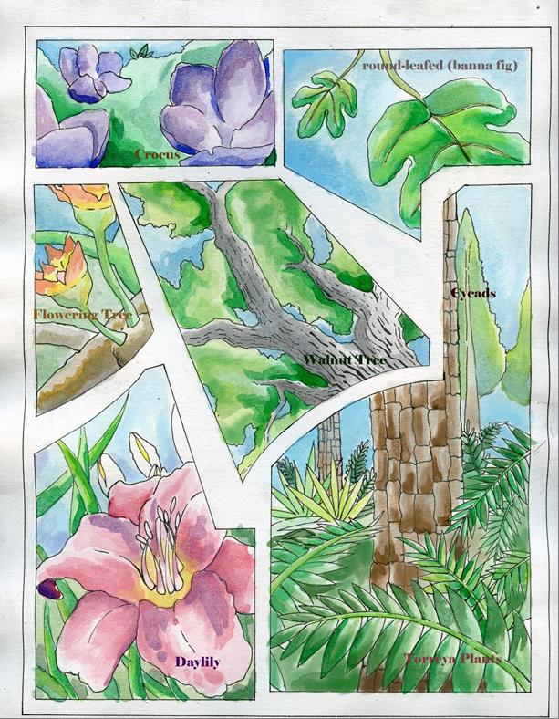
Malapoenna horrellensis   Laurel family
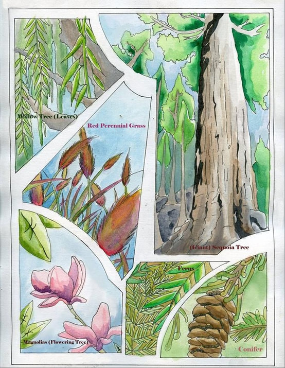
Phragmites pratti                Reed, perennial grass
Salix eutawensis                  Willow family
Salix flexuose                        Willow family
Sequoia reichenbachi         Sequoia, Cypress family, related to giant sequoia
 
     
Chimney Bluffs, Chattahoochee River
About 4.5 miles southwest of Cusseta, GA
This is Fort Benning property where Chattahoochee River makes it’s farthest eastern point in Chattahoochee County. The bluffs are eastward from the river point. The base bed of some bluffs about 5 feet high and shows dark, brown, coal-like, clay rich sand with black lenses of mica rich clay; lignite; as brown coal wood, is present in all forms from fragments to logs. Poorly preserved fossil leaves are abundant in some clay lenses.

E. W. Berry identified the following plants from this location.
Scientific Name                    Common Name
Araucaria bladenensis      Evergreen conifer   
Ficus crassipes                     Round-leafed banana fig               
Ficus krausiana                   Fig tree
Salix flexuosa                       Willow family
Salix lesquereuxii               Willow family
Sequoia reichenbachi        Sequoia, Cypress family, related to giant sequoia


Victory Drive Bridge
In Fort Benning, just southeast of Columbus where Victory Drive (Highway 27) crosses Upatoi Creek, Veatch and Stephenson report a wealth of fossil in the bluffs beneath the bridge. Reported vertebrate finds are three distinct species of Cretaceous sharks.


Upatoi Creek
Within Fort Benning, at the Muscogee/Chattahoochee County line is a location known as McBride Ford, 11 air-miles south of east Columbus, where a bluff stands on the south bank of the river.

Cretaceous material underlies about 6 feet of unconsolidated sands as an irregularly crossbedded sand/sandstone with chocolate to black clay lenses, angular quartz pebbles, feldspar fragments, with recognizable wood fragments as coal (lignite) in some cases as logs. Some of the clay lenses contain leaf fragments. One such lens, 6 to 10 inches thick, produced a number of well-preserved Cretaceous leaves which were collected for identification.

Reported Cretaceous plant fossils:
Scientific Name                                Common name
Andromeda cretacea                       Heath family, Flowering plant
Andromeda wardiana                    Heath Family, Flowering plant
Androvettia elegans                       Conifer
Aralia eutawensis                           Flowering shrub or tree
Brachyphyllum macrocarpum   Conifer
Cinnamomum heeri                        Cinnamon tree, Laurel family
Cinnamomum newberryi              Cinnamon tree, Laurel family
Eucalyptus angusta                        Eucalyptus, Myrtle family
Ficus ovatifolia                                  Fig tree or shrub
Manihotoides georgiana                Manihot, spurge, related to Cassava
Juglans arctica                                 Walnut family
Magnolia boulayana                      Magnolia; common Southeastern flowering tree
Magnolia capellinii                         Magnolia; common Southeastern flowering tree
Menispermites variabilis               Related to curare plant; Family; Menispermaceae
Paliurus upatoiensis                        Species of flowering shrub or small tree
Salix flexuosa                                    Willow family
Sequoia reichenbachi                      Cypress family, related to giant sequoia
Tumion carolinianum                     Genus; Torreya; related to Nutmeg Yew
Zizyphus laurifolious                      Related to Buckthorn
             

Chattahoochee River Bluffs at Blufftown, GA
This town is extinct but was mapped by Veatch and Stephenson at about 4.5 miles northeast of Omaha at a sharp eastward bend in the river in Stewart County approximately 31.25 air miles south of Columbus. From the bluffs they reported a wealth of Cretaceous invertebrates, shark’s teeth, fish vertebra and crab claws.


Omaha Railroad Bridge
One eighth mile below the railroad bridge east of Omaha Cretaceous invertebrates and shark fossils were collected at a level 5 to 8 feet above the water.


Florence/Omaha, GA; (As Florence Marina on some maps)
Stewart County; where Georgia Highway 39C (running east-west) runs into Georgia Highway 39 (running north-south). There is (was?) a bluff about 45 feet high with Cretaceous invertebrates, shark and crocodilian teeth occurring at the lower five feet of the middle strata, which is about 20 feet thick. These sediments are a grey, to green, clay rich marine sands.


Buena Vista/Tazewell Road
Reported as along the Buena Vista/Tazewell Road (State Highway 137, Dr. Deryl Hart Road); there is a hill from Tazewell back towards Buena Vista with the hill cresting where power lines cross the road (modern description). The lower 50 feet of this hill, on the Tazewell side, is composed of coarse, light colored, crossbedded, feldspar rich sand locally with iron concretions; with white to black clay lenses. The clay lenses are local in character giving place over a short distance to sand. The black clay lenses are sparsely leaf bearing and have a thickness of 4 to 5 feet.

Reported Cretaceous plants
Scientific Name                                Common Name 
Andromeda novae-caesareae        Heath family
Araucaria bladenensis                     Conifer; evergreen
Doryanthophyllum cretaceum      No Information Found, likely reassigned.
Eucalyptus angusta                          Eucalyptus
Ficus (Species?)                                   Fig
Manihotoides (Species?)                   Manihot, spurge, related to Cassava
Monocotyledon (Species)                 Monocot; family including daylilies & wheat


Byron, Georgia
At a point about 1.5 miles northeast of Byron in a railroad cut through an 18 foot high hill. The hill is crowned by a 5 to 8 foot layer of light gray to yellow, stratified, sand and clay of Cretaceous (?) age. Below this is a 10 foot layer of drab, layered, and laminated clay.  On the southwest end of the lower layer there is a six foot section of dark drab to chocolate colored clay containing Cretaceous plant fragments, these were collected and submitted to E. W. Berry

Cretaceous plants reported
Scientific Name                                Common Name
Araucaria jefferyi                            Conifer
Cunninghamites elegans                Conifer
Dryopteris                                           Fern

In 2012 Jay Batcha (Friend & Editor for the Mid-Georgia Gem and Mineral Society) and I tried to locate this Byron, Georgia location but the railroad cuts proved too overgrown. We located the hill crown but could not confirm fossil bearing sediments in a lower bed.


Clay County, Georgia at Pataula Creek, “The Narrows”
Two miles above junction with Chattahoochee River and nine miles north of Fort Gaines fossils from three species of Cretaceous sharks were collected.


Renfroe’s Station
Stewart County, reported in several railroad cuts 1 to 1.25 miles north of Renfroe’s Station, which no longer exists. The City of Renfroe stands on the Chattahoochee/Stewart County line and here the railway (or former railway) diverts northeast from following Highway 280 and heads across county through hilly terrain. Fossils are reported as both vertebrate shark fossils & invertebrate material loose in soils of the rail road cut, having weathered out. 

Ideal, Georgia
Reported in 1911 as a railroad cut 1 1/8 miles north of town, this may not be accurate or the original rail line may no longer exist. Current railroad is about 0.5 mile north of downtown in a series of side roads and bridges built around a low promontory where the railroad parallels Whitewater Creek. Three species of Cretaceous sharks, a mosasaur tooth and fragments of bone were recovered.

 
Artist Xavier Sims created these watercolors of Cretaceous plants to show a different Georgia than today; a tropical environment. 


Picture