7L; 1914 Report
Georgia Plant Fossils
From the Upper Cretaceous
By
Thomas Thurman
Filed; 21/Oct/2023
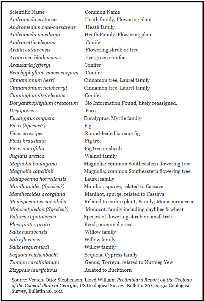
Dinosaurs once walked among magnolia trees in Georgia, they walked among eucalyptus trees, cinnamon and fig trees. There were sequoia, willow and many conider trees. All of these stood in our state 84 million years ago while dinosaurs still walked the Earth.
In 1914 Edward Wilbur Berry published a report, through the USGS, on known plant (flora) fossils from the upper Cretaceous and Eocene of South Carolina and Georgia. We’ll look at his report on Georgia, and even on this we’re going to break it up into Cretaceous and Eocene pages.
This is the Cretaceous page. Many of the Georgia plants Berry identified were new species he had personally described and published.
Berry introduces his Georgia section by stating “Up to the present time of the present study no fossil plants had been specifically recorded from the Coastal Plain of Georgia.”
Berry introduces his Georgia section by stating “Up to the present time of the present study no fossil plants had been specifically recorded from the Coastal Plain of Georgia.”
This is a bit of a misleading statement. The USGS and State of Georgia collaborated on a large report in 1911 on the Coastal Plain in general by Otto Veatch (Georgia Geological Survey) & Lloyd W. Stephenson (USGS) which identified many Cretaceous plant fossils from to the level of species. Turns out E. W. Berry identified many of those specimens, his name is reported fifty-plus time in the 1911 text, so he was a very active part of the 1911 report.
In his own 1914 paper over Georgia’s plant fossils Berry credits the work of our own intrepid State Geologist Samuel McCallie (1908-1933), Otto Veatch and Lloyd Stephenson. He even thanks Stephenson for the plant fossil information from Beuna Vista and Byron, GA, which Berry never visited.
In his own 1914 paper over Georgia’s plant fossils Berry credits the work of our own intrepid State Geologist Samuel McCallie (1908-1933), Otto Veatch and Lloyd Stephenson. He even thanks Stephenson for the plant fossil information from Beuna Vista and Byron, GA, which Berry never visited.
1914 Formations
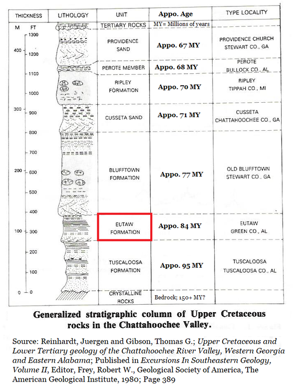
Berry’s 1914 understanding of our Cretaceous sediments was different than today’s, research was just getting started. He describes a triangular area with a narrow base at the Chattahoochee River and an apex east-northeast to the Ocmulgee River. He states that he collected from the Ripley Formation & the Eutaw Formation in Georgia, but even these are described differently than we know them today.
While his understanding of the sediments is different, his physical descriptions of the sediments, seen below, are detailed and accessible to most readers. They would be useful or corroborating locations in the field.
Ripley Formation
Providence Sand Member
Renfroe Marl (Middle division)
Cusseta Sand Member
Eutaw Formation
Tombigbee Sand Member
Lower division
Providence Sand Member
Renfroe Marl (Middle division)
Cusseta Sand Member
Eutaw Formation
Tombigbee Sand Member
Lower division
Ripley Formation (Berry 1914 text)
Cusseta Sand Member
The Cusseta member is typically developed in southeastern Chattahoochee County, near the town of Cusseta, where it consists of noncalcareous, rather micaceous, mostly unconsolidated quartz sands with local lenses of laminated clays and more extensive lenses of dark, massively bedded clays. It loses its distinctive character to the west along Chattahoochee River, where it is more or less glauconitic and fossiliferous, and to the northeast, where it merges with the underlying and overlying Upper Cretaceous sands. Beds believed to represent this horizon are fossiliferous along the Chattahoochee and contain plant fossils near Buena Vista and near Byron.
Middle Division
The middle part of the Ripley formation consists essentially of massive, micaceous, calcareous, and in many places glauconitic sand with calcareous nodules and dark, argillaceous, pyritiferous, lignitic sands and clays, the sands predominating. These deposits preserve their identity more or less completely from Chattahoochee River eastward across Stewart, Marion, and Schley counties, merging in Macon· County with the underlying and overlying Cretaceous sands. They carry an abundant marine fauna, and beds of this age across the border in Alabama have yielded a small flora markedly different in character from that described in the following pages.
The middle part of the Ripley formation consists essentially of massive, micaceous, calcareous, and in many places glauconitic sand with calcareous nodules and dark, argillaceous, pyritiferous, lignitic sands and clays, the sands predominating. These deposits preserve their identity more or less completely from Chattahoochee River eastward across Stewart, Marion, and Schley counties, merging in Macon· County with the underlying and overlying Cretaceous sands. They carry an abundant marine fauna, and beds of this age across the border in Alabama have yielded a small flora markedly different in character from that described in the following pages.
Providence Sand
The Providence sand consists essentially of variegated, more or less- cross-bedded sands which pass gradually into the underlying middle division of the Ripley (''Renfroe Marl" of Veatch), with the representatives of which they merge toward the east. They are un-fossiliferous and hence without interest in the present connection.
The Providence sand consists essentially of variegated, more or less- cross-bedded sands which pass gradually into the underlying middle division of the Ripley (''Renfroe Marl" of Veatch), with the representatives of which they merge toward the east. They are un-fossiliferous and hence without interest in the present connection.
Eutaw Formation (Berry 1914 text)
Lower Division
The part of the Eutaw formation in the Georgia area which underlies the Tombigbee member consists predominately of sands, coarse toward the landward margin, and elsewhere in many places calcareous and locally argillaceous and more or less glauconitic.
Lenses of dark laminated clay are not uncommon and contain many large teredo-bored logs. (Teredo refers to a wood boring, worm-like mollusk.) Silicified wood is common in the sands. At certain localities molluscan remains are not uncommon, and the clay lenses ordinarily carry vegetable matter. Along Chattahoochee River the sands of the lower division of the Eutaw are in places semi-lithified by the development of several courses of nodules cemented by carbonate of lime. Eastward the deposits pass into unconsolidated,
cross-bedded, ferruginous, and un-fossiliferous sands. The areal extent of these lower deposits is not great. They underlie the northern part of Chattahoochee and Marion counties, a small part of southern Muscogee County, and western Taylor County, beyond which they are not separable from the similar unconsolidated sands which characterize the overlying Upper Cretaceous deposits. They contain a fairly representative flora both in their basal and upper portions.
Tombigbee Sand Member
The Georgia representative of the Tombigbee Sand Member of the Eutaw Formation of Mississippi and Alabama is distinctive in character only along Chattahoochee River and for a few miles to the northeast, where it consists of more or less calcareous clays which are locally lignitic and of more or less argillaceous sands with thin layers of calcareous nodules. Eastward it cannot be traced beyond Marion County, where it becomes more sandy and is indistinguishable from the adjacent deposits of the Eutaw Formation and from the overlying Cusseta Sand member of the Ripley Formation. It contains marine invertebrates but has failed to yield any recognizable plant remains.
The Georgia representative of the Tombigbee Sand Member of the Eutaw Formation of Mississippi and Alabama is distinctive in character only along Chattahoochee River and for a few miles to the northeast, where it consists of more or less calcareous clays which are locally lignitic and of more or less argillaceous sands with thin layers of calcareous nodules. Eastward it cannot be traced beyond Marion County, where it becomes more sandy and is indistinguishable from the adjacent deposits of the Eutaw Formation and from the overlying Cusseta Sand member of the Ripley Formation. It contains marine invertebrates but has failed to yield any recognizable plant remains.
Five Localities
Berry was aware of 5 collecting localities, please bear in mind this is 1914 text written before the Chattahoochee was dammed, the dams were mostly complete by 1963.
Berry was aware of 5 collecting localities, please bear in mind this is 1914 text written before the Chattahoochee was dammed, the dams were mostly complete by 1963.
McBride’s Ford
Along the Left bank of Upatoi Creek in Chattahoochee County, about 10 miles southeast of Columbus (1914). Lower Eutaw Formation deposits above the ford rest with a marked unconformity on Lower Cretaceous clays. At about 10ft above low water a small lens of dark-drab clay 12 to 15 inches thick furnished plant remains listed below.
Along the Left bank of Upatoi Creek in Chattahoochee County, about 10 miles southeast of Columbus (1914). Lower Eutaw Formation deposits above the ford rest with a marked unconformity on Lower Cretaceous clays. At about 10ft above low water a small lens of dark-drab clay 12 to 15 inches thick furnished plant remains listed below.
Andromeda cretacea Heath family
Andromeda wardiana Heath family
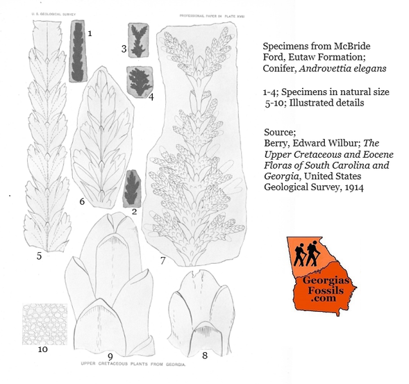
Androvettia elegans Conifer
Aralia eutawensis Aralia trees & shrubs
Brachyphyllum macrocarpum Conifer, short leaf
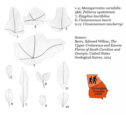
Cinnamomum heerii Cinamon, laurel family
Cinnamomum newberryi Cinamon, laurel family
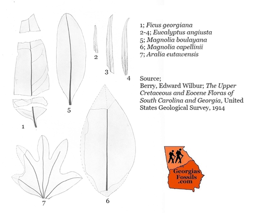
Eucalyptus augusta Eucalyptus Genus
Ficus ovatifolia Ficus (Fig tree relative)
Juglans arctica Genus includes walnut
Magnolia boulayana Magnolia Genus
Magnolia capellini Magnolia Genus
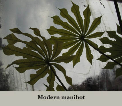
Manihotites georgiana Manihot Genus
Menispermites variabilis Curare family (poison dart)
Paliurus upatoiensis Small flowering tree
Salix flexuosa Willow Genus
Sequoia reichenbachi Sequoia Tree Genus
Tumion carolinianum Genus Torreya (Yew)
Zizyphus laurifolius Buckthorn family
Sequoia & Androvettia are the most abundant specimens.
Several unidentifiable forms including a fern were present, mostly as leaf fragments.
Several unidentifiable forms including a fern were present, mostly as leaf fragments.
Broken Arrow Bend
This locality includes outcrops on both banks of the Chattahoochee about 13 miles south of Columbus. The one closest to Columbus is on the Alabama bank and contains marine invertebrates. About 100 yards downstream in Chattahoochee County on the Georgia bank a more extensive section occurs including the below fossils. In places at the base of the bluff much eroded Lower Cretaceous surface rises to a height of about 5 ft. Overlying this is coarse cross-bedded sands of the lower Eutaw Formation with gravel, much lignite, and a few small lenses of dark shaly clay about a foot thick and 10 to 15 inches in diameter which holds poor lead impressions and considerable fragmented plant matter.
This locality includes outcrops on both banks of the Chattahoochee about 13 miles south of Columbus. The one closest to Columbus is on the Alabama bank and contains marine invertebrates. About 100 yards downstream in Chattahoochee County on the Georgia bank a more extensive section occurs including the below fossils. In places at the base of the bluff much eroded Lower Cretaceous surface rises to a height of about 5 ft. Overlying this is coarse cross-bedded sands of the lower Eutaw Formation with gravel, much lignite, and a few small lenses of dark shaly clay about a foot thick and 10 to 15 inches in diameter which holds poor lead impressions and considerable fragmented plant matter.
Malapoenna horrellensis Laurel family
Phragmites pratti Genus of reeds
Salix eutawensis Willow family
Salix flexuosa Willow family
Sequoia reichenbachi Sequoia family
Phragmites pratti Genus of reeds
Salix eutawensis Willow family
Salix flexuosa Willow family
Sequoia reichenbachi Sequoia family
An unidentified Ficus leaf was also recovered. Sequoia was the most abundant followed by Salix eutawensis, though they were usually broken.
Chimney Bluff
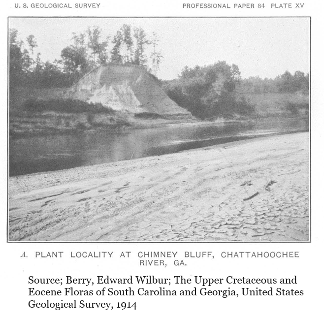
Chimney Bluff still stands on the Georgia bank of the Chattahoochee about 15 air miles south of Columbus in southernmost Chattahoochee County. It marks the furthest eastward point of the Chattahoochee River in central west Georgia.
In 1914 Berry offered an excellent, detail report of the Eutaw deposit which interested him (again, this author isn’t sure that this deposit would still be considered Eutaw Formation, nor that the entirety of this deposit is still above the waterline since the river was dammed, but Berry’s description is still useful.)
“…about 25 feet of irregularly bedded, laminated and cross-bedded, very lignitic (wood as brown coal), pyrite rich sand and clay, with small lenses of dark-drab clay carrying plant remains, the whole overlain by fine gray sand about 10 to 15 feet thick, above which, without conformity, are about 50 feet of yellowish or greenish very argillaceous (clay rich) sands which carry casts of marine invertebrates and which are believed to represent the Tombigbee sand.” The identifiable plants, which are from a layer near .the top of the lower division of the Eutaw, are as follows:
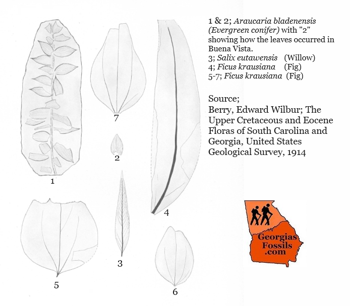
Araucaria bladenensis Evergreen conifer
Araucaria jeffreyi Evergreen conifer
Ficus crassipes Fig genus
Ficus krausiana Fig genus
Salix flexuosa Willow family
Salix lesquereuxii Willow family
Sequoia reichenbachi Sequoia family
Araucaria jeffreyi Evergreen conifer
Ficus crassipes Fig genus
Ficus krausiana Fig genus
Salix flexuosa Willow family
Salix lesquereuxii Willow family
Sequoia reichenbachi Sequoia family
Sequoia was reported as rare with Araucaria bladenensis being the most common plant represented by twigs and detached leaves. (The Eutaw Formation it is roughly 84 million years old.) Some modern Araucaria conifers reach more than 250ft in height.
Logs & Amber
Berry reported that the lower part of the exposure was remarkable for its large shipworm bored logs of lignite (lignite = brown coal which will burn). Logs 2 to 3 feet in diameter are not uncommon. You would think that a 84 million year old, Georgia log, 3 feet in diameter and riddled with shipworm holes, would be something Georgia museums would want to display, but being lignite I’m not sure good a display they would make.
Berry reported that the lower part of the exposure was remarkable for its large shipworm bored logs of lignite (lignite = brown coal which will burn). Logs 2 to 3 feet in diameter are not uncommon. You would think that a 84 million year old, Georgia log, 3 feet in diameter and riddled with shipworm holes, would be something Georgia museums would want to display, but being lignite I’m not sure good a display they would make.
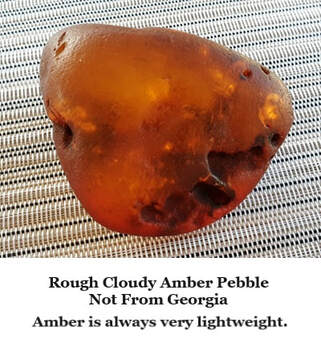
But Berry also mentions pellets of amber (fossilized tree resin) are also present.
Generally amber is rare in Georgia but here is a report of amber pellets from 1914. Better yet, Edward Berry reassigned the source for this amber from pine (Pinus) resin to conifer (Araucaria) resin.
Berry states; “In view of the persistent association of this fossil resin with Araucaria remains from North Carolina southward it seems probable that not all Upper Cretaceous ambers are derived from species of Pinus, though this, as shown by Hollick and Jeffrey, is the source of the amber from Staten Island, N. Y.”
So in Berry’s opinion, Georgia’s Eutaw Formation amber was formed from the resin of confers of the genus Araucaria. This genus was common in the Cretaceous and survives today through at least 20 species of trees ranging from 16 to 262 feet tall.
I posted this on Facebook’s Georgia’s Fossils Group in Oct/2023 since there are researchers in Georgia who are very familiar with the Chattahoochee River Valley fossils, I was even aware that Bill Montante, an advanced amateur, excitedly posted a piece of amber he’d found in the area a year or two before he passed. (We miss Bill.)
Schwimmer went on to explain that, so far, they found no amber with meaningful inclusions in Georgia. “Much of it is a bit cloudy, the few clear pieces only have a few specks and bubbles.” Schwimmer continued, “Additionally: amber is a common find in the Late Cretaceous. We don't usually report it because it is commonplace. Apparently, there were quite a few gymnosperm trees that shed resin during the Late Cretaceous.”
Schwimmer concluded by reporting that researchers working in Phenix City, Alabama sediments recovered amber with some insects and other inclusions Ingersoll Shale site. Dave Grimaldi from AMNH studied them and published his finds quite a few years ago.
According to Wikipedia, The Ingersoll Shale is a Late Cretaceous (Santonian) geological unit of the Eutaw Formation in eastern Alabama. Fourteen theropod feathers assigned to birds and possibly dromaeosaurids (feathered therapod dinosaurs) have been recovered from the unit as of 2011 and this represented the largest assemblage of feather from North American Mesozoic rocks.
So keep an eye out for amber when you are poking around in the Blufftown or Eutaw formations, you might be the one to find a clear piece with a scientifically meaningful inclusion. Apparently, we need to keep an eye out for feathers too. Wouldn’t it be fun to find a feather imprint among leaf impressions.
Buena Vista
The fossil plants Berry reported from Beuna Vista where recovered by Loyd W. Stephenson (USGS geologist) from a gully along the road connecting Buena Vista to Tazewell, about 6 miles northeast of Buena Vista, in Marion County, in deposits Stephenson identified as the Cusseta sand member of the Ripley formation. The identified samples.
The fossil plants Berry reported from Beuna Vista where recovered by Loyd W. Stephenson (USGS geologist) from a gully along the road connecting Buena Vista to Tazewell, about 6 miles northeast of Buena Vista, in Marion County, in deposits Stephenson identified as the Cusseta sand member of the Ripley formation. The identified samples.
Andromeda novaecaesareae Heath family
Araucaria bladenensis Evergreen conifer
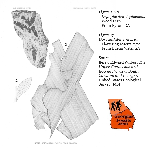
Doryanthites cretacea Flowering rosetta-type
Eucalyptus augusta Eucalyptus family
Ficus georgiana Fig family
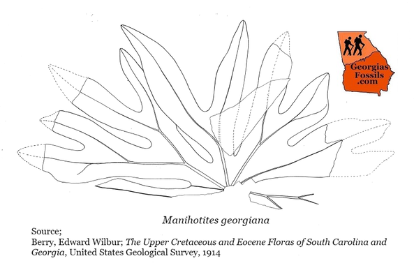
Manihotites georgiana Manihot family
Araucaria bladenensis Evergreen conifer
Doryanthites cretacea Flowering rosetta-type
Eucalyptus augusta Eucalyptus family
Ficus georgiana Fig family
Manihotites georgiana Manihot family
Berry & Stephenson report that leaf impressions are scattered and poor with perhaps the most abundant being the Doryanthites. The Araucaria is represented by detached leaves and all of the remains show evidence of trituration.
(“Trituration” was a term unknown to me and a quick search define it as “grind into a fine powder or chew or grind thoroughly, Berry and Stephenson seemed to believe the Aruacaia were being fed on.)
(“Trituration” was a term unknown to me and a quick search define it as “grind into a fine powder or chew or grind thoroughly, Berry and Stephenson seemed to believe the Aruacaia were being fed on.)
Byron
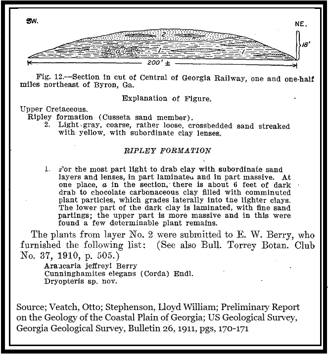
Cretaceous plant fossils occur on the northside of a railroad cut about 1.5 miles north of Byron, GA. Berry reported on a locality where Lloyd Stephenson (USGS) collected dinosaur-aged plant fossils sometime prior to 1911. Berry & Stephenson attributed the deposit to the Cusseta Sand. The exposure is rather coarse, cross-bedded, feldspar rich sand with local, modest clay lenses. The leaf remains are contained in a massive, dark-drab clay which carries much fragmented vegetable matter which grades horizontally and vertically into laminated clay with fine sand partings. The identifiable plants are few and poor but contain:
Cretaceous plant fossils occur on the northside of a railroad cut about 1.5 miles north of Byron, GA. Berry reported on a locality where Lloyd Stephenson (USGS) collected dinosaur-aged plant fossils sometime prior to 1911. Berry & Stephenson attributed the deposit to the Cusseta Sand. The exposure is rather coarse, cross-bedded, feldspar rich sand with local, modest clay lenses. The leaf remains are contained in a massive, dark-drab clay which carries much fragmented vegetable matter which grades horizontally and vertically into laminated clay with fine sand partings. The identifiable plants are few and poor but contain:
Araucaria jeffreyi Evergreen conifer
Cunninghamites elsgans Conifer, cypress related
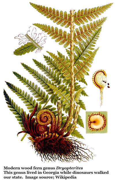
Dryopterites stephensoni Wood fern
Cunninghamites elsgans Conifer, cypress related
Dryopterites stephensoni Wood fern
The Cunninghamites is the most common specimen, but preservation is poor. Fragments of dicotyledonous (dicot) leaves are present but furth identification is impossible.
Discussion (1914)
Berry reported that he’s reviewed 32 identifiable species in this report but considered this a “meager picture” of the probable plant population of Georgia during the Cretaceous. Even in 1914 Berry was aware of abundant floras reported in northwest Alabama and northeast South Carolina.
Of course, work by Reinhardt in 1980 (see section of this website 7J: Field Trip Report, Chattahoochee River Valley 1980 Cretaceous, Paleocene, & Eocene) showed that there was much work left to do on plant fossils in the Chattahoochee River Valley and the work by Herendeen (See section; 7K: Cretaceous Mesofossils Plants of Crawford County, GA) show that central Georgia also ahs stories to tell about Cretaceous plants in Georgia.
Berry missed this in his report. He was aware of other formations in Georgia’s Chattahoochee River Valley, and that some of them were shallow water and near shore, but he believed that contemporary current and wave action was too violent for identifiable material to survive.
|
Download Berry's 1914 paper at right...
|
| ||||||
References:
- Berry, Edward Wilbur; The Upper Cretaceous and Eocene Floras of South Carolina and Georgia, United States Geological Survey, 1914
- Veatch, Otto; Stephenson, Lloyd William; Preliminary Report on the Geology of the Coastal Plain of Georgia; US Geological Survey, Bulletin 26 Georgia Geological Survey, Bulletin 26, 1911
- Knight, Terrell K.; P. Sean Bingham; Ronald D. Lewis, and Charles E. Savrda. 2011. Feathers of the Ingersoll shale, Eutaw Formation (Upper Cretaceous), eastern Alabama: The largest collection of feathers from North American Mesozoic rocks. PALAIOS 26. 364–376
