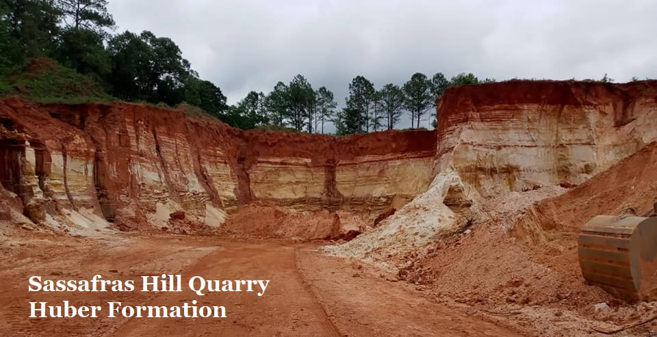
9B: Sassafras Hill Quarry
Huber Formation
Plant Fossils in Kaolin
By
Thomas Thurman
Posted 29/May/2023
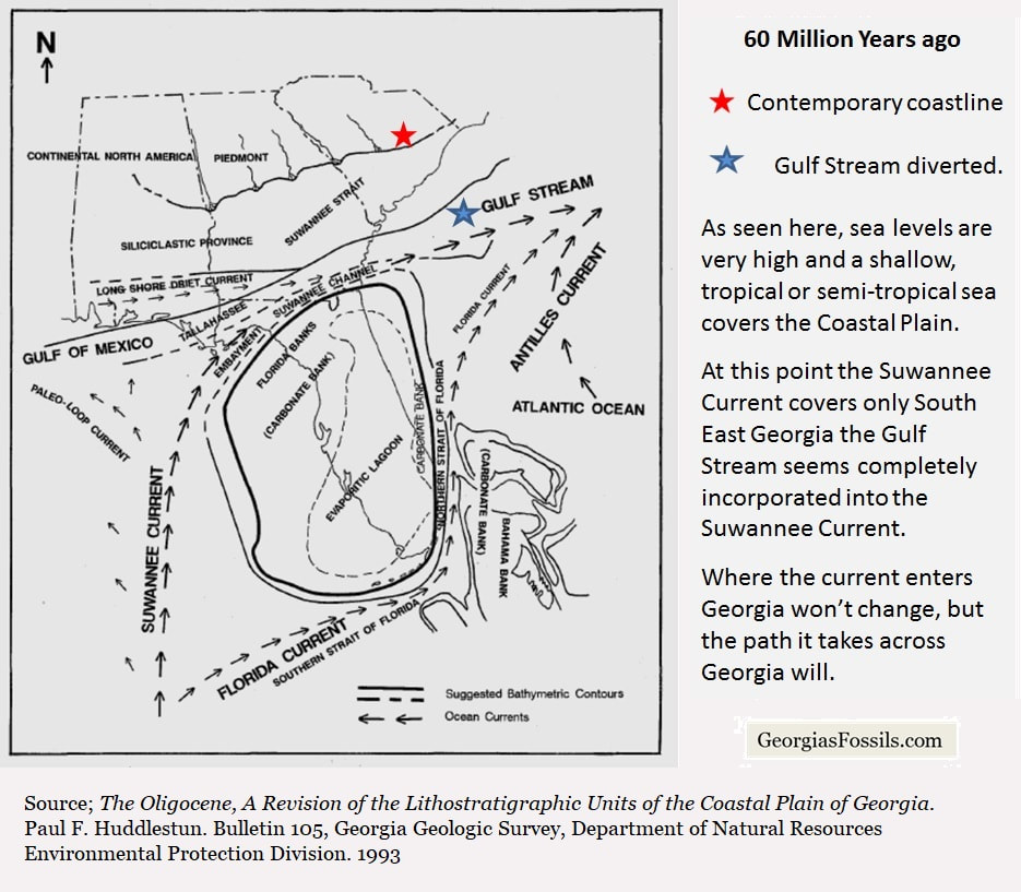
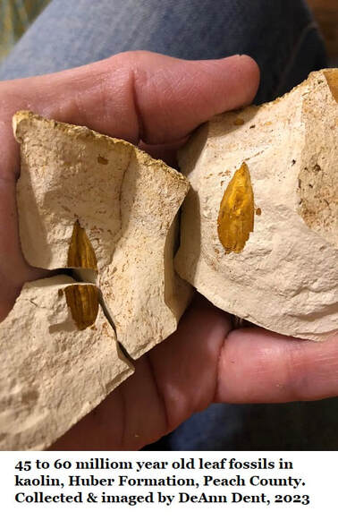
Perhaps 60 million years ago a leaf fell into the paleo-Flint River, drifted downstream, became waterlogged and sank as it was swept through the river delta. The leaf was carried out to sea until it got caught in the northern edge the Suwannee Current and pushed back up towards the coast.
The waters of the paleo-Flint were already loaded with sand and clay minerals before that leaf fell. When the river reached the Suwannee Current the current trapped the leaves and clay along that fall line.
That fallen leaf, and many like it, settled to the bottom just north of where Highway 96 would (much later) run east-west through Peach and Houston Counties.
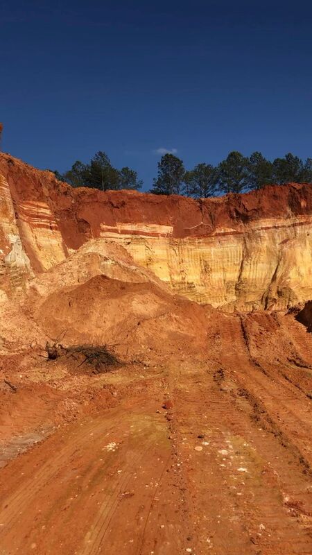
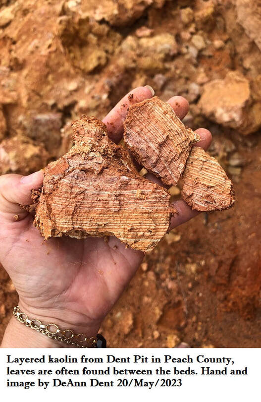
The sediments were disturbed in the sandy kaolin beds of Sassafras Hill, a seeming eternity later, by Kevin Dent’s heavy equipment. He needed the sand and clay for various projects. So Sassafras Hill Quarry isn’t a kaolin mine, but just a small private excavation for construction.
That fallen leaf, and many like it, settled to the bottom just north of where Highway 96 would (much later) run east-west through Peach and Houston Counties.
The sediments were disturbed in the sandy kaolin beds of Sassafras Hill, a seeming eternity later, by Kevin Dent’s heavy equipment. He needed the sand and clay for various projects. So Sassafras Hill Quarry isn’t a kaolin mine, but just a small private excavation for construction.
Kaolin
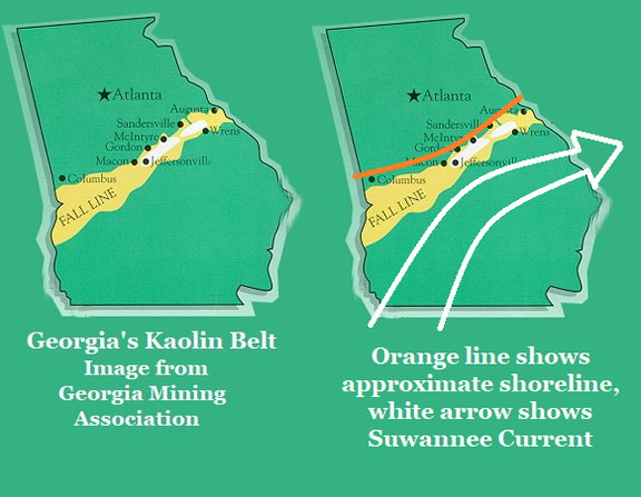
Georgia's kaolin formed from sediments carried down rivers and deposited along an ancient coastline that followed the modern Fall Line. Sea levels rise and fall. Coastline rise and fall. The our vast beds of kaolin were deposited Georgia’s coast was sometimes just north of the Fall Line and sometimes it was just south of the Fall Line.
Often called chalk, kaolin is actually a fine-grained white clay mineral famously used to make porcelain, among many other things. It’s Georgia’s most heavily mined mineral with the kaolin belt stretching across the state just south of the Fall Line. The clay minerals which became kaolin were eroded out of the Piedmont and into our rivers. Rivers which have existed in Georgia for 100 million years, or more, though their river deltas have been as restless as our shorelines.
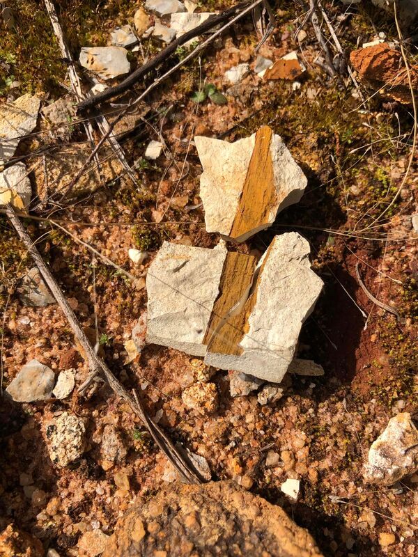
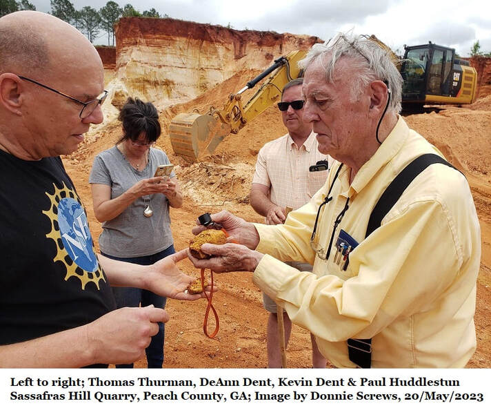
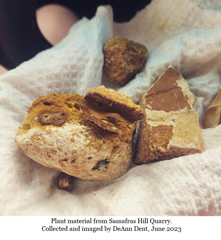
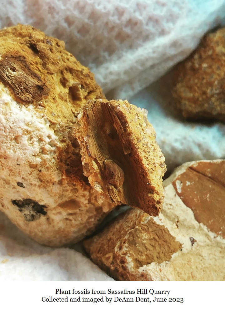
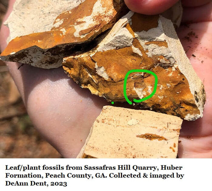
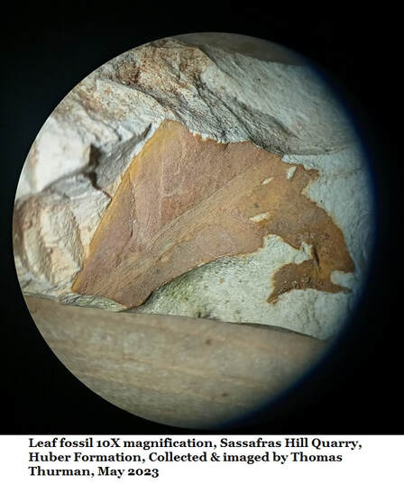
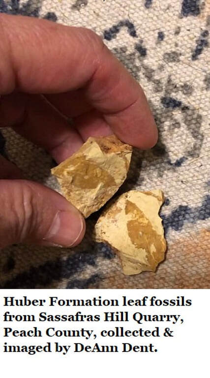
Kevin’s ever-curious wife DeAnn Dent is a teacher (teachers tend to be curious) and when she spotted a familiar brown leaf shape on a kaolin rock, the picked it and saw the leaf’s veins and structure, she was shocked and a little puzzled. Could this really be an old leaf? She found a few more leaves and posted pictures of them in Georgia’s Fossils Group on Facebook.
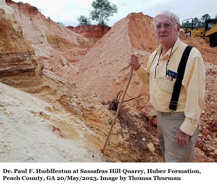
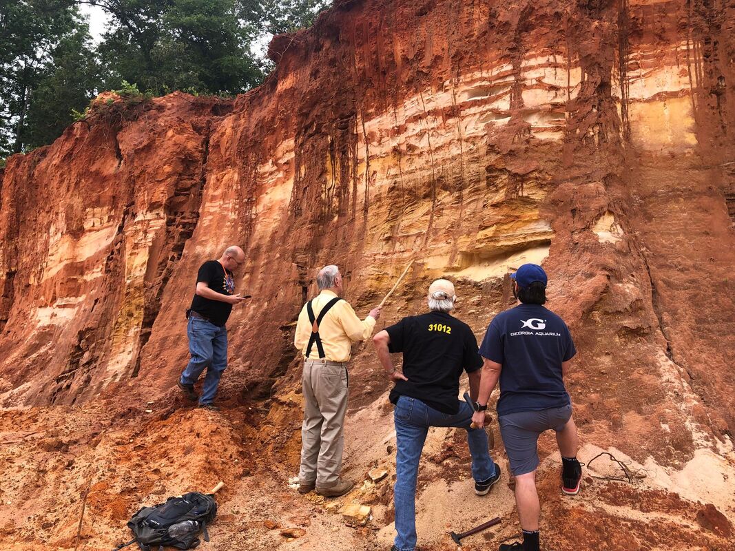
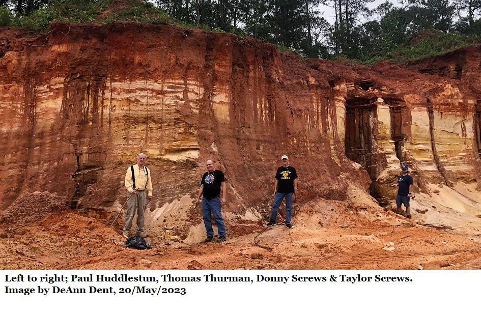
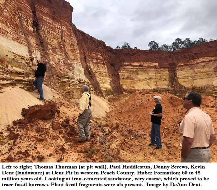
That’s how I got involved. Deann & Kevin invited me over for a look. On 20/May/ 2023 I was joined by Georgia’s famous Coastal Plain stratigraphy expert Paul F. Huddlestun (retired, Georgia Geologic Survey). Donny and Taylor Screws, the father/son science teacher team, also came along.
Donny is a retired Science Teacher, his son Taylor teaches in the same Classroom Donny knew.
Spending a day in the field, especially in the woods, with Donny and Taylor Screws is a treat that should not be missed by any fan of Georgia’s nature. They are both natural educators explorers.
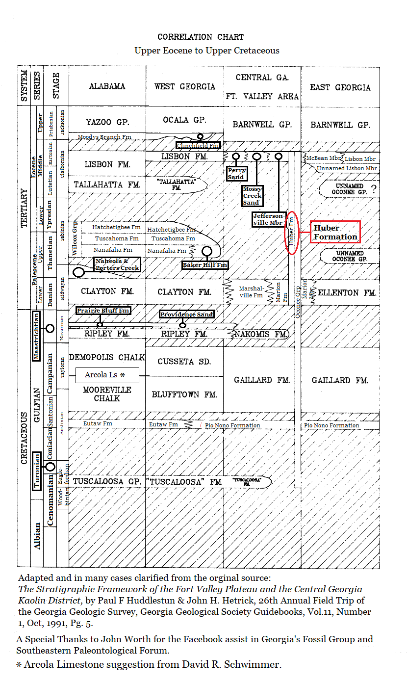
Mr. Paul identified the leaf bearing deposit as the Huber Formation. We don’t have good information on the Huber’s exact age as the normal marker fossils, foraminifera, simply aren’t present in the kaolin, but it’s at least 45 million years old, perhaps as much as 60 million years old.
Donny is a retired Science Teacher, his son Taylor teaches in the same Classroom Donny knew.
Spending a day in the field, especially in the woods, with Donny and Taylor Screws is a treat that should not be missed by any fan of Georgia’s nature. They are both natural educators explorers.
Mr. Paul identified the leaf bearing deposit as the Huber Formation. We don’t have good information on the Huber’s exact age as the normal marker fossils, foraminifera, simply aren’t present in the kaolin, but it’s at least 45 million years old, perhaps as much as 60 million years old.
The Science
The Sassafras Hill Quarry is near the Houston/Peach County line between Bonaire and Fort Valley, it is on private property and admission requires both permission and supervision.
The represented environment would have been coastal marine, the site is currently about halfway between the Flint & Ocmulgee Rivers. There is some evidence of tidal disturbance when the sediments were laid down, so the shoreline probably was just north of the quarry.
There are three kaolin bearing formations in the area which sporadically have plant fossils, two are members of the Oconee Group, one is of the Fort Valley Group. The Huber Formation of the Sassafras Hill Quarry is a member of the Oconee Group.
In its simplest terms, the Oconee Group and the Fort Valley Group.
- The Oconee Group is fluvial in origin, meaning sourced by river borne sediments.
- The Fort Valley Group is of coastal marine origin; estuarine, bay, sound, lagoon, and/or barrier island.
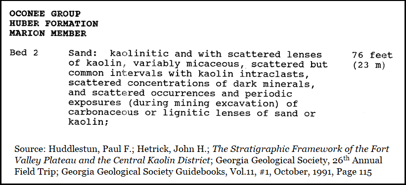
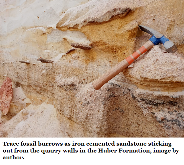
In 1991 Paul Huddlestun and John Hetrick recognized "carbonaceous or lignitic lenses" in the Huber formation. Carbonaceous refers to formerly living material. Lignitic is carbonized wood.
In 1990 John H. Hetrick and Michael S. Friddell published a geologic atlas of the central Georgia kaolin district (Geologic Atlas 6, available below for download). And while their research area began in Twiggs County, it applies here. Some of the kaolin beds they reviewed contained “leaf impressions and pollen of bio-stratigraphic significance.” “Bio-stratigraphic significance” means that this plant material has potential use in dating the beds and describing the environment. Seeing this, they called for further research.
Hetrick and Friddell were absolutely right about the plant material in the kaolin, a great deal could be learned about contemporary environments by identifying the pollen and leaves. I’ve heard rumor that there’s another research looking at this, and I’ve reached out to him, but he has not replied to emails.
If such research results is unknown in Georgia, if it doesn’t add to our knowledge of Georgia’s natural history, then what’s been gained for Georgia by the research? There are paleobotanist here in Georgia. We already know something about plant material in our Cretaceous sediments, in 1911 Veatch & Stephenson reported several finds. (Section 22A of this website.) We need to expand this knowledge.
GGS Field Trip
The Oconee Group was formally introduced to Georgia’s Geologic Society by in 1991 by Paul F. Huddlestun and John Hetrick in a field trip. Such field trips, guided by experts, are the best way to learn an area’s geology and paleontology.
Huddlestun had just published two major reports on the Coastal Plain deposits from the Late Eocene through the Holocene and was working on another over the Oligocene, which is particularly maddening here on the northern Coastal Plain.
Hetrick, on the other hand, was just completing two years of research through the area the field trip would review, he’d published two atlases on the subject. (The second being Atlas 7, Geologic Atlas of the Fort Valley Area, available below for download) So the 1991 Field Trip was led by two leading experts.
This was the 26th Annual Field Trip of the Georgia Geological Society (GGS). (Also available below for download)
|
Hetrick & Friddle; Geologic Atlas 6 to right:
|
| ||
|
John Hetrick's; Geologic Atlas 7 to right:
|
| ||
|
Huddlestun & Hetrick's 1991 GGS Field Trip:
|
| ||
Oconee Group
Fort Valley Group
- Middle Eocene, Late Claibornian
- Jeffersonville Member of the Huber Formation
- Marion Member of the Huber Formation
- Early Paleocene, Midwayan age
- Buffalo Creek Kaolin member of the Gaillard Formation
- Huber Formation (Early Paleocene to Middle Eocene)
- Marion Member
- Jeffersonville Member
- Late Cretaceous
- Galliard Formation
- Pio Nono Formation
Fort Valley Group
- Upper Eocene
- High terrace fluvial (river sourced) deposits,
- Both Flint & Ocmulgee Rivers
- Unnamed channel deposits east of the Ocmulgee River
- High terrace fluvial (river sourced) deposits,
- Middle Eocene (?)
- Butler-Allon channel deposits
- Fall Line Hills near the Flint River
- Butler-Allon channel deposits
- Middle Eocene (Claibornian Age)
- Perry Sand
- Mossy Creek Sand
- Early Paleocene (Midwayan Age)
- Huber Formation (Early Paleocene to Middle Eocene)
- Marion Member
- Jeffersonville Member
- Marshallville Formation
- Huber Formation (Early Paleocene to Middle Eocene)
- Late Cretaceous
- Nakomis Formation
A History of Research
More than a century ago the Georgia Geologic Survey requested assistance from the US Geological Survey (USGS) to explore, describe, and investigate the economic significance of Coastal Plain deposits. The 1911 report by Otto Veatch and Llyod Stephenson included list of vertebrate, invertebrate, and plant fossils mostly identified to the level of genus at least. This is especially true for Cretaceous plants. But few Paleocene or Eocene plants have been identified in Georgia despite many historical references to the presence of both. Little to no further work, to my knowledge, has been done in Georgia since.
More than a century ago the Georgia Geologic Survey requested assistance from the US Geological Survey (USGS) to explore, describe, and investigate the economic significance of Coastal Plain deposits. The 1911 report by Otto Veatch and Llyod Stephenson included list of vertebrate, invertebrate, and plant fossils mostly identified to the level of genus at least. This is especially true for Cretaceous plants. But few Paleocene or Eocene plants have been identified in Georgia despite many historical references to the presence of both. Little to no further work, to my knowledge, has been done in Georgia since.
|
Veatch & Stephenson's 1911 report to right:
|
| ||
References:
- Thurman, Thomas; The Suwannee Current, Gulf Trough, & Bridgeboro Limestone, Section 8, GeorgiasFossils.com
- Hetrick, John H.; Friddell, Michael S.; A Geologic Atlas of the Central Kaolin District; Geologic Atlas 6, Georgia Geologic Survey, 1990
- Huddlestun, Paul F.; Hetrick, John H.; The Stratigraphic Framework of the Fort Valley Plateau and the Central Kaolin District; Georgia Geological Society, 26th Annual Field Trip; Georgia Geological Society Guidebooks, Vol.11, #1, October, 1991
- Hetrick; John H.; Geologic Atlas of the Fort Valley Area, Geologic Atlas 7, Georgia Geologic Survey, 1990
- Huddlestun, Paul F., & Hetrick, John H. Upper Eocene Stratigraphy of Central and Eastern Georgia, Georgia Department of Natural Resources, Environmental Protection Division, Bulletin 95. 1986.
- Huddlestun, Paul, F.; A Revision of the Lithostratigraphic Units of the Coastal Plain of Georgia. The Miocene Through Holocene, Bulletin 104, Georgia Geologic Survey, 1988
- Paul F. Huddlestun; A Revision of the Lithostratigraphic Units of the Coastal Plain of Georgia, THE OLIGOCENE, Georgia Department of Natural Resources, Georgia Geologic Survey, Bulletin 105, 1993
- Veatch, Otto; Stephenson, Lloyd William; Preliminary Report on the Geology of the Coastal Plain of Georgia; US Geological Survey, Georgia Geological Survey, Bulletin 26, 1911