28A: Late Eocene & Earlier
Coastal Plain Stratigraphy
Alabama, Georgia, & Mississippi
Inspired by the Albany Core
By Paul Huddlestun
Emailed text: 28/June/2021
Email from Paul Huddlestun
28/June/2021
Thomas:
Here, finally, is the Albany core log and an informal discussion of my present thoughts on the stratigraphic relationships of the various Late Eocene and earlier stratigraphic units. It would have to be tedious for readers to wade through but there is currently no other source of this stratigraphic information in the published literature and I felt that the readers of your website needed some kind of explanation for all this razzmatazz.
What I have written below is only a first draft with two edits to try to eliminate as many of the bloopers as possible. If readers have trouble with the Oligocene, Miocene, and Pliocene, they can refer to published literature.
If I were publishing this write-up, it would take another 7 or 8 drafts and I have no idea however much more time to wade through all of the literature and relationships between cores and outcrops. Read it over and see if you need any more information/corrections to understand what I’m trying to say.
Well, now I can get back to the Upper Eocene talk. And I can forward this on to you and not worry anymore about pressing a wrong key and permanently deleting the whole thing.
Paul
(Note; The below explanation was only lightly edited by T. Thurman towards ease of navigation and access for readers not versed in geologic terminology. Actual content was not touched.)
Note from Mr. Paul on the below text:
"My 'little' write-up was/is not intended to be a 'formal' document. I have not put any names on unnamed formations. My intent is to inform the interested public where I currently stand on the Georgia Coastal Plain and stratigraphic terminology. What I have written is intended to be a “heads up” for anyone interested in the stratigraphic framework and stratigraphic terminology of the Coastal Plain, and that is as close to nature and what is out there as I can currently put together. I do not have confidence in the formal literature. There are way too many people that have published 'formal' reports and have led unsuspecting, interested geologists down the garden path."
"My 'little' write-up was/is not intended to be a 'formal' document. I have not put any names on unnamed formations. My intent is to inform the interested public where I currently stand on the Georgia Coastal Plain and stratigraphic terminology. What I have written is intended to be a “heads up” for anyone interested in the stratigraphic framework and stratigraphic terminology of the Coastal Plain, and that is as close to nature and what is out there as I can currently put together. I do not have confidence in the formal literature. There are way too many people that have published 'formal' reports and have led unsuspecting, interested geologists down the garden path."
The Albany Core
Paul F. Huddlestun
28/June/2021
(The Albany Core Report is available immediately below as a Word file.)
You can also find it on the Core Logs by Paul F. Huddlestun Page
Paul F. Huddlestun
28/June/2021
(The Albany Core Report is available immediately below as a Word file.)
You can also find it on the Core Logs by Paul F. Huddlestun Page
| albany_core_tt__ggs_3187__army_core_of_engineers__ace_.doc | |
| File Size: | 134 kb |
| File Type: | doc |
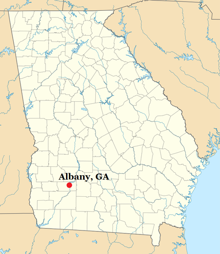
The Albany core is the most critical core we have of relating the stratigraphy of the pre-Upper Eocene, classical eastern Gulf of Mexico, Alabama/Mississippi Coastal Plain sections to the eastern Georgia Coastal Plain sections south and east of the Gulf Trough. The location of the Albany core is on the southeastern side of Albany and is west of the Gulf Trough. The closest intermediate Gulf Trough core to the Albany core, which is outside of the Trough, is the Doerun core from the northwestern corner of Colquitt County. The Albany core contains downdip, offshore versions of the outcropping Upper Eocene and pre-Upper Eocene stratigraphic units of western Alabama. Those Alabama sections are relatively downdip and offshore compared with the original near-shore, Alabama sections that are long eroded away and gone. The closest place to get an impression of the once far-updip Alabama sections are in Georgia east of the Flint River. The pre-Upper Eocene sections in the Albany core are somewhat different from the modern, outcropping sections in southwestern Alabama and result in part from eastward facies change passing into the southern Atlantic Coastal Plain.
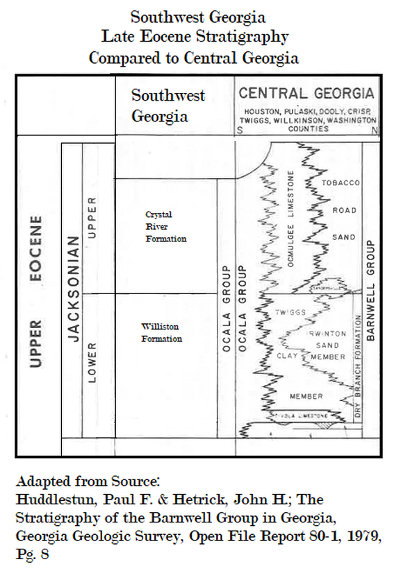
The entire section of the cored Paleogene in the Albany core is as follows: The Crystal River Limestone that is the prominent upper Jacksonian formation of the Ocala Group south of the Gulf Trough, is not present in the Albany core nor in outcrops in the Albany area or in other known exposures along the Flint River. This lithofacies is somewhat more similar to the calcareous phase of the Ocmulgee (Formation) than it is to other subdivisions of the Ocala Group. Although the type locality of the Ocmulgee is all granular limestone that is thickly bedded like that along the Flint River, almost all of the cores containing Ocmulgee contain appreciable sand, clay and marl. The variably fossiliferous, granular limestone of the Flint River, upper Jacksonian is not known to contain these other lithic components. On the other hand, an Ocmulgee-like limestone with an Ocmulgee planktonic foraminifera fauna is (was?) exposed in a road cut on Pecan Road west of Lake Blackshear in southeastern Sumter County. The extent of this granular, upper Jacksonian limestone that occurs between the Ocmulgee Formation (shoreward/updip) and the known occurrence of the Crystal River Limestone south of the Gulf Trough is unknown due to the lack of subsurface core information. The granular upper Jacksonian limestone does appear to grade laterally trough-ward into similar granular limestone within the Gulf Trough in Colquitt County.
LATE EOCENE, UPPER JACKSONIAN
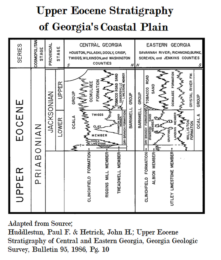
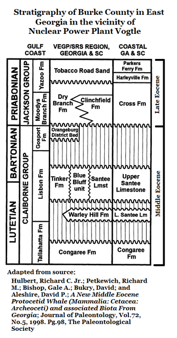
The distribution of upper Jacksonian lithostratigraphic units, starting with the most up dip, coastward deposits is as follows:
The distribution of upper Jacksonian lithostratigraphic units, starting with the most up dip, coastward deposits is as follows:
The Tobacco Road Sand
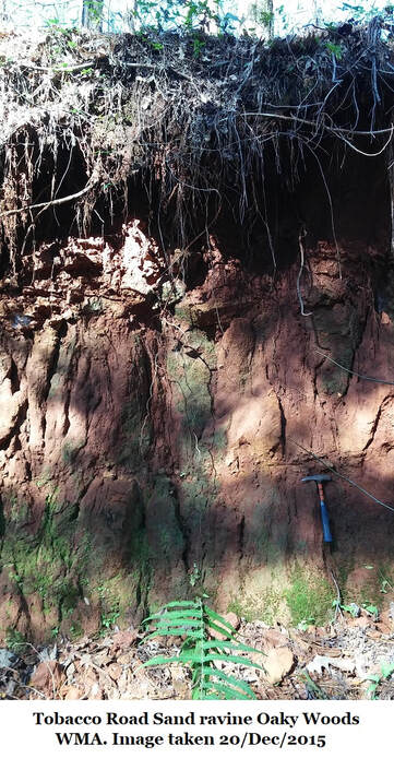
The Tobacco Road Sand, of the mostly siliciclastic Barnwell Group, is there farthest updip deposit of the upper Jackson. It occurs almost to the Fall Line in Washington County but is more distant from the Fall Line area in east and west of Washington County. The Tobacco Road is of coastal beach to shoreface origin. It contains a localized limestone member, the Sandersville Limestone, that is restricted to the central part of Washington County.
The Tobacco Road Sand, of the mostly siliciclastic Barnwell Group, is there farthest updip deposit of the upper Jackson. It occurs almost to the Fall Line in Washington County but is more distant from the Fall Line area in east and west of Washington County. The Tobacco Road is of coastal beach to shoreface origin. It contains a localized limestone member, the Sandersville Limestone, that is restricted to the central part of Washington County.
The Sandersville Limestone
(See Section 14F of this website)
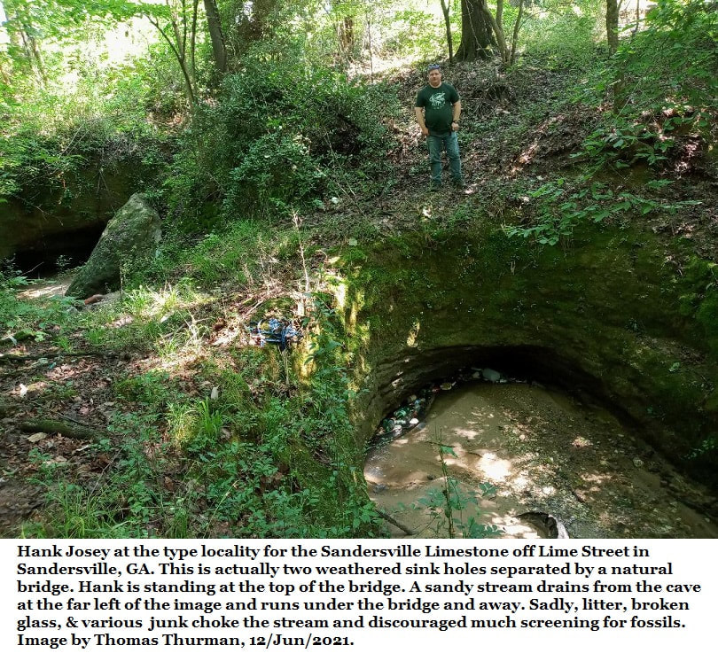
The Sandersville Limestone is interpreted to have been deposited in a very shallow water, coastal Bay that was temporarily isolated from rivers/coastal marine drift supplies of sand. The Sandersville Formation grades, rather abruptly over a few miles seaward into the Ocmulgee Formation.
The Ocmulgee Formation
(See Section 14E of this website)
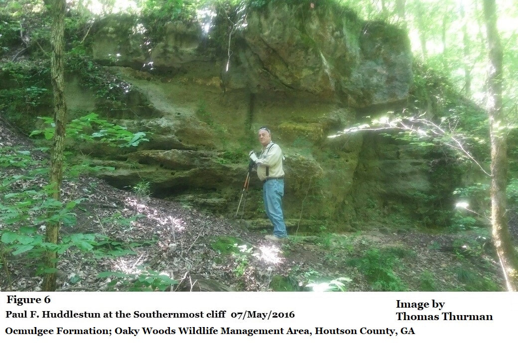
The Ocmulgee is a formation of inner neritic, shelf-bottom origin that contains an appreciable content of clay and argillaceous sand beds in cores. The Ocmulgee clay and sand beds are not encountered in outcropping Ocmulgee Formation due to lack of resistance to weathering in the South Georgia climate. The Ocmulgee unexpectedly contains a fairly diverse suite of planktonic microfossils along with the sand dollar, Periarchus quinquefarius and Periarchus quinquefarius kewi. The most reasonable interpretation for this unusual mix of open-marine, normal salinity, planktonic microfossils with normally coastal environment sand dollars, is the presence of strong currents in the continental shelf environment during the late Jacksonian. Such microorganisms are adapted to a relatively stable, open marine environment would not last long on entering coastal waters with fluctuating physical conditions. The nature of the offshore gradation of the Ocmulgee Formation into a more open marine limestone is largely unknown in central Georgia due to lack of adequate, downdip core control in central Georgia north of the Gulf Trough. Within the Gulf Trough, however, the upper Jacksonian (Ocmulgee Formation) limestone is mostly a finely to very finely granular limestone that contains some sucrosic dolostone beds in some cores; is variably glauconitic to nil glauconite; slightly and variably very finely sandy to mostly nil sand, some minor chert and pyrite; minor traces of mica; lignitic material and rare, fine phosphatic, biodebris and carbonaceous flecks; and minor and scattered occurrences of macrofossils including bryozoans, Discocyclinid larger foraminifera and scattered and rare Lepidocyclina and Nummulites. Stratification ranges from massive and structureless in some beds to bioturbated in a few beds, to thinly and vaguely layered in other beds to flaggy with hard poker chips. The limestone interval between what is almost certainly upper Jacksonian limestone and the underlying Claibornian Limestone in the Gulf Trough may be either lower Jacksonian or upper Jacksonian. The lithic contents are similar and there is inadequate biostratigraphy to be certain of their real stratigraphic position. The above lithic contents of the Gulf Trough, upper Jacksonian seems to suggest that some or much of the upper Jacksonian contents of the trough are derived from downslope movement from higher up on the flanks of the channel walls. Such down-slope movement could have been caused by periodic storms/hurricanes and strong, scouring currents on the sea-floor above the channel depths.
Crystal River Limestone
The (Upper Jacksonian) Crystal River Limestone occurs south of the Gulf Trough in southwestern and central Georgia and is continuous into central Florida, the type area of the Ocala Limestone. In eastern coastal Georgia and northeastern coastal Florida, the Crystal River grades eastward into an unnamed bryozoan limestone that is mostly a bryozoan coquina to a sub-coquina. In the area there are no cores of the facies change of the Crystal River into the bryozoan limestone south of the Savannah River area but, based on Florida Geological Survey cores in northeastern Florida, the area appears to be quite abrupt and occurs between Trail Ridge and the Coast. If that location holds in Georgia, the area of facies change in Georgia would then be between the Orangeburg Escarpment and the coast. However, there used to be a string of cores in the near vicinity of the Savannah River from the McBean Creek area in northern Burke County, every few miles through Burke, Screven, and Chatham County; most of which are sufficiently deep to form a clear picture of the lithofacies change in the entire Jacksonian from the Barnwell Group in Richmond County to the Ocala Group in coastal in Chatham County. In that string of cores, it is clear that in the Savannah River area, the Tobacco Road Sand grades rather abruptly into the Ocmulgee Formation in the vicinity of the Burke/Screven Counties line. The Ocmulgee Formation grades laterally into the bryozoan limestone by the gradual increase in bryozoans in central Screven County, and the bryozoan limestone constitutes the entire upper Jacksonian from central Screven County to the coast.
The (Upper Jacksonian) Crystal River Limestone occurs south of the Gulf Trough in southwestern and central Georgia and is continuous into central Florida, the type area of the Ocala Limestone. In eastern coastal Georgia and northeastern coastal Florida, the Crystal River grades eastward into an unnamed bryozoan limestone that is mostly a bryozoan coquina to a sub-coquina. In the area there are no cores of the facies change of the Crystal River into the bryozoan limestone south of the Savannah River area but, based on Florida Geological Survey cores in northeastern Florida, the area appears to be quite abrupt and occurs between Trail Ridge and the Coast. If that location holds in Georgia, the area of facies change in Georgia would then be between the Orangeburg Escarpment and the coast. However, there used to be a string of cores in the near vicinity of the Savannah River from the McBean Creek area in northern Burke County, every few miles through Burke, Screven, and Chatham County; most of which are sufficiently deep to form a clear picture of the lithofacies change in the entire Jacksonian from the Barnwell Group in Richmond County to the Ocala Group in coastal in Chatham County. In that string of cores, it is clear that in the Savannah River area, the Tobacco Road Sand grades rather abruptly into the Ocmulgee Formation in the vicinity of the Burke/Screven Counties line. The Ocmulgee Formation grades laterally into the bryozoan limestone by the gradual increase in bryozoans in central Screven County, and the bryozoan limestone constitutes the entire upper Jacksonian from central Screven County to the coast.
Williston Limestone
The lower Jacksonian Williston Limestone is both more variable lithicly than the upper Jacksonian limestones but is also more internally consistent across the larger expanse of Georgia. One variation of the lithology of the Williston is the local Muckalee Member in southwestern Georgia described in the Georgia Geological Society Fieldtrip, 1995 guidebook. The updip limits of the Williston in central Georgia and its style of gradation into the Dry Branch Formation of the Barnwell Group is unknown in Georgia west of the Savannah River area. In the Savannah River area, however, the Griffins Landing Member of the Dry Branch.
The lower Jacksonian Williston Limestone is both more variable lithicly than the upper Jacksonian limestones but is also more internally consistent across the larger expanse of Georgia. One variation of the lithology of the Williston is the local Muckalee Member in southwestern Georgia described in the Georgia Geological Society Fieldtrip, 1995 guidebook. The updip limits of the Williston in central Georgia and its style of gradation into the Dry Branch Formation of the Barnwell Group is unknown in Georgia west of the Savannah River area. In the Savannah River area, however, the Griffins Landing Member of the Dry Branch.
The Clinchfield Sand
(See Section 14B of this website, Mr. Paul & I disagree about the age of the Clinchfield.)
The Clinchfield Sand of the Barnwell Group is uncertain at this time because of lack of necessary biostratigraphic clarification of the unit. The Clinchfield Sand occurs in the same relative stratigraphic position to other formations as does the Gosport Sand in Alabama. However, the Gosport has always been identified as a part of the Middle Eocene, Claibornian and has been included in calcareous nannofossil Zone NP17 (Middle Eocene). In Georgia, in contrast, the Clinchfield has always been considered to be a part of the Barnwell Group and because the rest of the Barnwell is Late Eocene in age, the Clinchfield has been considered to be Late Eocene in age. The stratigraphic relationships of the Gosport Sand and the Clinchfield Sand with the underlying Lisbon Formation (disconformable) and the overlying Moodys Branch in Alabama (apparently gradational), and the Clinchfield/Huber-Lisbon contact (disconformable) whereas the Tivola/Dry Branch contact in Georgia (apparently gradational), it is possible (and even probable at this time) that the Clinchfield Sand is Gosport-equivalent and late Middle Eocene, Claibornian in age. Therefore the real stratigraphic position and age of the Clinchfield Sand must be carefully documented by definitive biostratigraphic markers. Periarchus lyelli is the best Gosport guide fossil available to field geologists but is inadequate for precision correlation at this time.
Fossiliferous, Periarchus-bearing sand occurs in the relative stratigraphic position of the Clinchfield in Williston lime pits northwest of Albany and, therefore, is identified as the Clinchfield Sand here. There is no sand deposit in the Clinchfield relative stratigraphic position in the Albany core southeast of Albany. However, there is a limestone unit that occurs above the Lisbon-equivalent limestone (Cook Mountain-equivalent) that is referred to as “Interval 1” in these downdip core logs presented on this web site: the Cockspur Island, Pineora, Davis Hopkins, and Thomas 5 cores. This limestone has been identified as occurring in Zone NP17 of the calcareous nannofossil zonation and Zone NP17 is late Claibornian in age and is the zone that contains the Gosport Sand of Alabama. In the Savannah River area, the Utley Limestone Member of the Clinchfield Sand thickens downdip in Screven County before disappearing. It is possible that the “Interval 1” limestone in far downdip cores is a less sandy, thicker lithofacies (or expression) of the Utley Limestone. With further subsurface information in Screven and northern Effingham Counties, the Utley Limestone may prove to be a legitimate name for the “Interval 1” limestone.
MIDDLE EOCENE
The stratigraphic sequence within the Middle Eocene has not yet been completely resolved across the eastern Gulf and lower Atlantic Coastal Plains, from Mississippi through Georgia (as can be inferred from the above discussion). The most completely subdivided and named Middle Eocene sequence is that of the eastern Mississippi outcrop area.
The upper part of the Middle Eocene there (underlying the Yegua-Cockfield; Gosport Sand-equivalent), is the Cook Mountain Formation of the Northern Gulf Coastal Plain (the Wautubbee Formation in Mississippi) and biostratigraphically is characterized by the Cubitoastrea sellaeformis Zone (C. sellaeformis is a large, saddle shaped oyster).
The named members of the Cook Mountain in eastern Mississippi are, from younger to older, the Gordon Creek Shale Member, the Potterchitto Member, and the Archusa Marl Member. This sequence grades into the upper Lisbon in Alabama and, in eastern Alabama according to Lyman Toulmin, only the upper-most part of the Cook Mountain subdivisions are present on the Chattahoochee River. Similarly, in the Lisbon outcrop area of Georgia, only the upper-most subdivision is recognized from the Chattahoochee River to the Savannah River. In Georgia the Blue Bluff Member of the Lisbon Formation differs from typical Lisbon Formation in being finer grained/textured and more calcareous.
|
Blue Bluff Formation
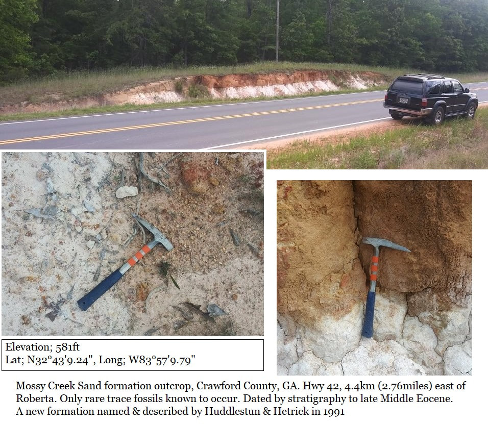
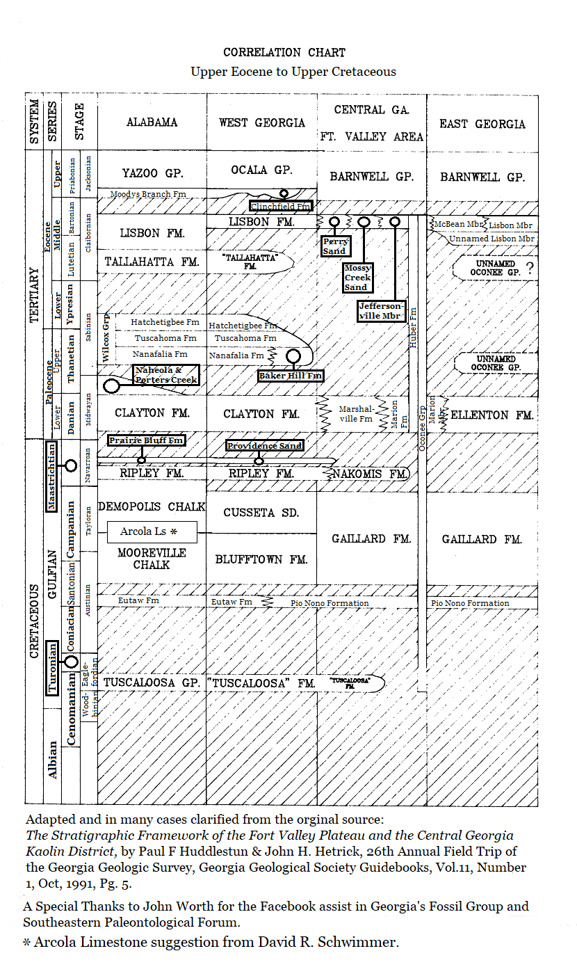
Perry Sand, Mossy Creek Sand, & Marshallville Formation In Georgia, the Blue Bluff (source matrix for the whale Georgiacetus vogtlensis) grades laterally updip/shoreward into the shoreface lithofacies of the Perry Sand, a very distinctive lithostratigraphic sand unit, but occurring in a relatively narrow band across southwestern and central Georgia, and into South Carolina. In the Fort Valley region and eastward to the Ocmulgee River area, the Perry Sand is known to grade laterally updip/shoreward into a coarser grained sand reminiscent of the Tobacco Road Sand, the Mossy Creek Sand. Both the Mossy Creek Sand and the Perry Sand are known to grade laterally updip again into the nonmarine, Blue Bluff-equivalent, Jeffersonville Member of the Huber Formation. Additionally, there is an informal sand deposit exposed in the Gaillard sand pits in Crawford County, that overlies the truncated Marshallville Formation called the Butler-Allon channel deposits by Huddlestun and Hetrick (1991). The Butler-Allon channel deposits appear to be a channel-fill deposit of the earliest, late Middle Eocene transgression in the area. |
Hard Kaolin beneath the Perry Sand & Blue Bluff
There are “hard” kaolin, stratigraphic units that underlie the Perry Sand and Blue Bluff Member of the Lisbon in the downdip region of the kaolin belt. The real stratigraphic positions of these kaolin subdivisions of the Huber haven’t yet been documented although pollen studies have indicated that earlier Claibornian units are also present in the kaolin belt. Where such kaolin units are identifiable in cores, such as the Arrowhead core in Pulaski County, the kaolinitic deposit underlying the Perry/Blue Bluff-equivalent kaolinitic unit is arbitrarily referred to the early Lisbon, Still Branch, depositional interval. Because this Pre-Blue Bluff, Lisbon kaolinitic subdivision is a real, unnamed stratigraphic subdivision of the Huber Formation, the name Jeffersonville for the uppermost subdivision of the Huber Formation is retained in this report.
There are “hard” kaolin, stratigraphic units that underlie the Perry Sand and Blue Bluff Member of the Lisbon in the downdip region of the kaolin belt. The real stratigraphic positions of these kaolin subdivisions of the Huber haven’t yet been documented although pollen studies have indicated that earlier Claibornian units are also present in the kaolin belt. Where such kaolin units are identifiable in cores, such as the Arrowhead core in Pulaski County, the kaolinitic deposit underlying the Perry/Blue Bluff-equivalent kaolinitic unit is arbitrarily referred to the early Lisbon, Still Branch, depositional interval. Because this Pre-Blue Bluff, Lisbon kaolinitic subdivision is a real, unnamed stratigraphic subdivision of the Huber Formation, the name Jeffersonville for the uppermost subdivision of the Huber Formation is retained in this report.
Beneath the Cooke Mountain is the Kosciusko-Sparta Sand in Mississippi, which is in the Cubitostrea smithvillensis Zone (the immediate ancestor of C. sellaeformis) of the central and western Gulf of Mexico Coastal Plain. This phase of the Claibornian extends only as far east as the Conecuh River in central Alabama according to Toulmin, and is largely of non-marine origin in Alabama. The Cubitostrea smithvillensis Zone is not known to be present in the outcrop area of the Claibornian in Georgia.
The lower Lisbon of Alabama grades westward in eastern Mississippi into the Zilpha Clay and Winona Greensand. This phase of the Middle Claibornian is biostratigraphically characterized by the Cubitostrea lisbonensis Zone, the ancestor of the later Cubitostrea. According to Toulmin, this phase of the middle Claibornian is not present on the Chattahoochee River. However, the lower Lisbon (Middle Claibornian) in Georgia is the Still Branch Sand. The typical Still Branch has not yet been recognized in outcrop in the Savannah River area but its updip member, the Bennock Millpond Member, is present in outcrop at the junction of McBean Creek floodplain and the Savannah River floodplain, and is the source of the “McBean” fossils described in the early literature. The Still Branch Sand is recognized in the shallow subsurface across Georgia to the Flint River area and is a dominantly calcareous, thick bedded, fine to coarse grained, massive bedded sand.
The pre-Lisbon, lower Claibornian of western Alabama is the Tallahatta (siliceous buhrstone) Formation which is not present, lithostratigraphically, in Georgia or in eastern Alabama. The lithology of the formation is its place is the Congaree Formation of South Carolina. In many places, in outcrops and cores, the Georgia Congaree is indistinguishable from the type Congaree of South Carolina. Downdip and relatively offshore, the Congaree grades into a massive bedded, fine to coarse grained sand (similar to the Still Branch) that is mappable in the subsurface but is not known to crop out. It is possible that the sand does exist in the outcrop area of the lower Claibornian in Georgia but due to its prevalence of well washed and well sorted, incoherent, medium to coarse grained sand that is only slightly argillaceous and lacking sufficient binding matrix to hold the quartz sands together, the loose sand results in little to no core recovery.
The USGS people have subdivided the Congaree (“Tallahatta”) into bio-stratigraphically upper and lower parts, the lower part being Eocene in age. Such a subdivision is not apparent litho-stratigraphically in Georgia and cannot be confirmed in this report. Herrick (1961) considered the top of the glauconitic, greensands to be “Tallahatta” Formation in the subsurface of Georgia, based on well cuttings. In cores, the first occurrence of the greensands appear, at this time, to be unevenly distributed from the lower Claibornian downward to the Hatchetigbee/Bashi, Sabinian, Lower Eocene. To date, the top, age/ages, or real stratigraphic positions of the greensands in the subsurface of Georgia have not been resolved. However, based on the current information, it would appear that the Hatchetigbee/Bashi interval is the most consistently glauconitic interval in the Georgia subsurface.
It appears at this time, that all of the marine Claibornian stratigraphic units in Georgia grade updip into nonmarine, mostly “hard” kaolins and sands of the Huber Formation. The specific correlations within the Huber Formation with the various marine Claibornian lithostratigraphic intervals have not yet been thoroughly documented. The “hard” kaolins of the Huber appears to be generally similar to that of the kaolins of the older, Nanafalia-equivalent, Baker Hill Formation. However, the Baker Hill kaolins appear to be somewhat more lithically variable than that of the Huber kaolins.
The above discussion of the Mississippi and Alabama Claibornian is relevant to the subsurface Claibornian limestone of Georgia in that there are a number of lithologically distinct intervals within the larger Claibornian limestone that have not been reliably correlated across the various downdip cores. There also appears to be more lithostratigraphic subdivisions of the limestone than can be correlated with the outcropping Claibornian (as well as pre-Claibornian stratigraphic units). These unresolved, apparent stratigraphic units have been referred to in these lithologs as stratigraphic “intervals” in order to stress their informality and lack of known real stratigraphic positions and correlations. As a result, it is likely that there are as yet unidentified stratigraphic relationships between the subsurface subdivisions/intervals of Georgia and the Mississippi-western Alabama Claibornian.
EARLY EOCENE
Hatchetigbee and Bashi Formations
The stratigraphy of the Early Eocene and Paleocene subsurface of Georgia seem somewhat less complicated than that of the Claibornian. The lower Eocene, Hatchetigbee and Bashi Formations of the Wilcox Group are known to crop out in Georgia only in western Georgia and consist of one subsurface stratigraphic unit in the lower Flint River area and eastward. The Hatchetigbee Formation per se is known only in the Randolph County area; elsewhere the lower Eocene interval appears to consist only of Bashi-equivalent, strongly glauconitic/greensands with variably calcareous, argillaceous sands. As described above, at this time it appears that the most widespread and most glauconitic of the Tertiary deposits in Georgia is the subsurface lower Eocene. It is also noted that the glauconitic, Lower Eocene formation is not lithostratigraphically Bashi or Hatchetigbee but is currently unnamed for lack of information on its detailed stratigraphic characteristics and subsurface extent.
LATE PALEOCENE
Nanafalia, Tucahoma & Baker Hill Formations
The Nanafalia and Tuscahoma Formations of the Wilcox Group are the only representatives of the Upper Paleocene, Sabinian/Thanetian, marine deposits in western and central Georgia. The Nanafalia Formation is primarily a sand formation whereas the Tuscahoma is a fine sand and clay formation in Georgia. Both the Nanafalia and Tuscahoma Formations have been traced as far east as Houston County. They have not been traced farther east because of lack of deeper, downdip core control east of Houston County. However, the Baker Hill Formation has been traced as far east as Laurens County. Because the Nanafalia Formation is known to grade laterally into the Baker Hill Formation in Sumter County, it is assumed here that the Nanafalia may occur in the subsurface of southern Laurens County. In the Savannah area the Snapp Formation occurs in the stratigraphic position of the Baker Hill Formation and Nanafalia/Tuscahoma Formations but its real stratigraphic position in that area has yet to be defined biostratigraphically, being deficient of known microfossils. The one core that apparently penetrates the Upper Paleocene, Thanetian, in the Savannah River area is the Pineora core in southern Effingham County. The stratigraphic interval, Interval 8 in the Pineora core (included on this page), is neither Nanafalia Formation nor Tuscahoma Formation. Similarly, farther south in the Davis-Hopkins core in Wayne County, Interval 9 in that core occurs in the relative stratigraphic position of the Nanafalia/Tuscahoma and the few planktonic foraminifera extracted from that interval are compatible with Nanafalia/Tuscahoma equivalent. However, Interval 9, or any other stratigraphic interval in that core, is incompatible with Nanafalia/Tuscahoma lithology.
The Nanafalia is known to grade updip (shoreward), unevenly, into the Baker Hill Formation, a kaolin-bearing formation that is mined for kaolin in Sumter County. The stratigraphic relationship of the Baker Hill to the kaolinitic Snapp Formation of the Oconee Group in Burke County is unknown because of lack of subsurface control between the westernmost known occurrence of Baker Hill in Laurens County and the Snapp Formation in Burke County. However, they appear to be two different kaolinitic formations in the same relative stratigraphic position. The Gravel Creek Formation described by Toulmin occurs in the same real stratigraphic position in Alabama as does the Baker Hill Formation in Georgia; it has been described as grading and thinning downdip into the Nanafalia Formation. Toulmin described the Gravel Creek as thin but occurring along the Chattahoochee River and also containing white clay that, in Alabama, has been referred to as “bauxite”, and may be kaolin. It is possible that the Gravel Creek and Baker Hill are continuous; only further studies can elucidate this stratigraphic problem. The marine Nanafalia and Tuscahoma, as well as the Lower Eocene Bashi and Hatchetigbee are off lap in Georgia relative to the underlying Midwayan formations and overlying Claibornian formations.
MIDDLE PALEOCENE
Middle Paleocene, upper Midwayan, Selandian has not, hitherto, been recognized in Georgia. This includes the stratigraphic equivalents of typical Porters Creek Clay and Naheola Formation of western Alabama. In the Albany core, there is an upper part of the Midwayan “Clayton” that appears to dis-conformably overlie the basal Clayton with a distinctly different sand lithology. This “upper Clayton” underlies the Nanafalia Formation dis-conformably and, therefore, is possibly Porters Creek/Naheola-equivalent. The planktonic foraminiferal assemblage is too sparse for bio-stratigraphic purposes and for one to be confident in the real stratigraphic position of the interval. The only other possible upper Midwayan, Naheola/Porters Creek-equivalents so far detected occur in Intervals 10 and 11 in the Pineora core and in Interval 11 in the Davis-Hopkins core. If these correlations are correct, this would indicate that the upper Midwayan is offlap to both the underlying Clayton Formation and the overlying Nanafalia Formation.
Middle Paleocene, upper Midwayan, Selandian has not, hitherto, been recognized in Georgia. This includes the stratigraphic equivalents of typical Porters Creek Clay and Naheola Formation of western Alabama. In the Albany core, there is an upper part of the Midwayan “Clayton” that appears to dis-conformably overlie the basal Clayton with a distinctly different sand lithology. This “upper Clayton” underlies the Nanafalia Formation dis-conformably and, therefore, is possibly Porters Creek/Naheola-equivalent. The planktonic foraminiferal assemblage is too sparse for bio-stratigraphic purposes and for one to be confident in the real stratigraphic position of the interval. The only other possible upper Midwayan, Naheola/Porters Creek-equivalents so far detected occur in Intervals 10 and 11 in the Pineora core and in Interval 11 in the Davis-Hopkins core. If these correlations are correct, this would indicate that the upper Midwayan is offlap to both the underlying Clayton Formation and the overlying Nanafalia Formation.
LOWER PALEOCENE
The Lower Paleocene, Midwayan, Clayton Formation and equivalents are the only representative of the earliest Paleocene in the Georgia Coastal Plain outcrop belt and is the first formation deposited after the Cretaceous extinctions.
The Lower Paleocene, Midwayan, Clayton Formation and equivalents are the only representative of the earliest Paleocene in the Georgia Coastal Plain outcrop belt and is the first formation deposited after the Cretaceous extinctions.
Clayton Formation
(See Sections 9 & 9A of the website)
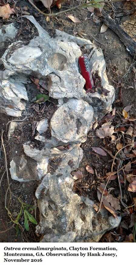
The lithology of the Clayton is quite variable across Alabama and Georgia, in different areas or different sites it may be represented by sands, clays, marls, and limestones; or all of the above. The Clayton is only exposed in the western part of Georgia, from the vicinity of the Flint River westward. In the Fort Valley area, the Clayton Formation grades laterally updip and coastward into the coastal marine, shoreface and kaolinitic lithofacies of the Marshallville Formation. The Marshallville appears to extend across Georgia through Twiggs, Wilkinson and Laurens Counties to Richmond County, and grades downdip in southern Richmond County into the Clayton Formation in Burke County. The Clayton Formation in Burke County has been referred to in the past as Ellenton Formation by Siple and others, and to the Black Mingo Formation by Huddlestun in 1996. Huddlestun (1996) referred the Clayton to the Black Mingo in Burke County based on Burke County’s proximity to the type area of the Black Mingo Formation in South Carolina. The closest known occurrence of the Clayton Formation to the Savannah River area in Georgia is in Houston County. Based strictly on lithology, the Ellenton/Black Mingo lithology of Burke County is easily within the sphere of the known lithologies of the Clayton Formation of western Georgia and Alabama and, for simplicity, the lowest Midwayan deposit in Burke County is placed in the Clayton Formation here (for a detailed description of the Clayton Formation in Burke County, see Huddlestun, 1996, Bulletin 127 of the GGS).
In the updip area of the Clayton Formation in the Fort Valley area, in Houston County, and in northern Sumter County, the Clayton Formation is very largely a noncalcareous clay and locally contains variable amounts of sand beds and lignitic fragments; the clay of the Clayton resembling the lithology of the Porters Creek Formation of Alabama. Farther south and downdip, the formation becomes more sandy and calcareous with unpredictable proportions of marl, sand, clay and limestone beds at any particular site. Continuing downdip, the formation becomes more calcareous with a higher proportion or dominance of limestone beds. In both the Pineora and Davis-Hopkins cores, the Clayton-equivalent intervals consist of limestone, sandy limestone, and calcareous sand with a domination of limestone.
Midway Formation
Concerning the lithostratigraphic terminology of the lower Midway, Huddlestun in 1991 proposed a number of new lithostratigraphic units in the Fort Valley area. One of them, the Fort Valley Group, was very closely related to the lithologies of the kaolin-bearing Oconee Group. The stratigraphic distinction was that the Oconee Group stratigraphic units were characterized by fining upward sequences and displayed no marine, lithic characteristics. The Fort Valley Group, on the other hand, did not display appreciable fining upward sequences but displayed coastal marine characteristics such as herring bone crossbedding that is of tidal origin. Other than that, the two groups were lithologically similar enough that unpracticed geologists and non-professional people could have trouble in discriminating between the two groups. Later, it became apparent that I was unable to differentiate the two groups in cores and, therefore, the lithic distinctions of the two groups was invalid, null and void. In that case, the primary group is the Oconee Group which must include the kaolins and kaolinitic sands of the former Fort Valley Group as subdivisions within the of the Oconee Group. This includes the Marshallville Formation, the Upper Cretaceous, Nakomis Formation and, possibly, the Providence Sand. Other kaolinitic and kaolinitic sand formations that include the Baker Hill Formation, and the Tuscaloosa-equivalent sand in the Columbus area, appear to be physically isolated from the Oconee Group. The Perry Sand and the Mossy Creek Sand cannot be included in the Oconee Group on lithologic grounds. Another formation that could be included in the Oconee Group, if it were physically connected with the Group is the Altamaha Formation of Miocene age. The Altamaha Formation is an Oconee Group-type formation that was deposited in a similar depositional environment and most closely resembles the lithology of the Upper Cretaceous, Pio Nono Formation of the Oconee Group.
Concerning the lithostratigraphic terminology of the lower Midway, Huddlestun in 1991 proposed a number of new lithostratigraphic units in the Fort Valley area. One of them, the Fort Valley Group, was very closely related to the lithologies of the kaolin-bearing Oconee Group. The stratigraphic distinction was that the Oconee Group stratigraphic units were characterized by fining upward sequences and displayed no marine, lithic characteristics. The Fort Valley Group, on the other hand, did not display appreciable fining upward sequences but displayed coastal marine characteristics such as herring bone crossbedding that is of tidal origin. Other than that, the two groups were lithologically similar enough that unpracticed geologists and non-professional people could have trouble in discriminating between the two groups. Later, it became apparent that I was unable to differentiate the two groups in cores and, therefore, the lithic distinctions of the two groups was invalid, null and void. In that case, the primary group is the Oconee Group which must include the kaolins and kaolinitic sands of the former Fort Valley Group as subdivisions within the of the Oconee Group. This includes the Marshallville Formation, the Upper Cretaceous, Nakomis Formation and, possibly, the Providence Sand. Other kaolinitic and kaolinitic sand formations that include the Baker Hill Formation, and the Tuscaloosa-equivalent sand in the Columbus area, appear to be physically isolated from the Oconee Group. The Perry Sand and the Mossy Creek Sand cannot be included in the Oconee Group on lithologic grounds. Another formation that could be included in the Oconee Group, if it were physically connected with the Group is the Altamaha Formation of Miocene age. The Altamaha Formation is an Oconee Group-type formation that was deposited in a similar depositional environment and most closely resembles the lithology of the Upper Cretaceous, Pio Nono Formation of the Oconee Group.
Huber Formation
(Marion Member & Marshallville Formation)
Frank Buie, in his 1978 formal proposal of the Huber Formation, included all Tertiary kaolin-bearing deposits in Georgia within the Huber Formation. Before that the Oconee Group kaolinitic deposits had no formal name and had been loosely included in the Tuscaloosa Formation of Alabama. In the outcrop area of Georgia there are two clear and distinct Tertiary, kaolinitic units in the Huber Formation that Buie described: the Claibornian unit for which Huddlestun in 1991 proposed the name Jeffersonville Member, and the kaolinitic Marion Member for the Clayton-equivalent, Midwayan member of the Huber Formation. At the time, it was essential not to cut out and subdivide a stratigraphic unit from a previously proposed, encompassing, and adopted stratigraphic unit, according to the various Codes of Stratigraphic Nomenclature. However, this recommendation in the Codes introduces a problem in the choice of the stratigraphic name to retain and the one to abandon. The Clayton-equivalent stratigraphic, kaolinitic unit has two names; the Marshallville Formation in the Fort Valley area, and the Marion Member of the Huber Member, mostly east of the Ocmulgee River. I know of no naturally occurring exposures of the Marion Member of the Huber; all of the good exposures of the unit are in kaolin pits. On the other hand, the type locality of the Marshallville Formation in the bluff north of Marshallville, is an excellent natural exposure, easily accessible, and will be available to geologists for an indefinite period in the future. As a result, I would prefer to adjust the stratigraphic terminology, in spite of the recommendations of the Stratigraphic Codes, in the following manner: the Marshallville Formation should include all kaolin bearing and kaolinitic sands of Clayton-equivalent of the lower Midway in Georgia; the Huber Formation should included all the hard kaolins and kaolinitic sands of the Claibornian in Georgia.
UPPER CRETACEOUS
The upper Cretaceous seems rather simple compared with the lower Tertiary described above. The youngest Cretaceous formations are the Providence Sand and the downdip stratigraphic equivalent, the Prairie Bluff Formation.
The upper Cretaceous seems rather simple compared with the lower Tertiary described above. The youngest Cretaceous formations are the Providence Sand and the downdip stratigraphic equivalent, the Prairie Bluff Formation.
The Providence Sand
& Prairie Bluff Formations
The Providence Sand has only been recognized in western Georgia, west of the vicinity of the Flint River. It can be easily identified in outcrop and in cores with the Perote, lignitic Member at the base of the formation. It may occur east of the Flint River in the sub-surface, but no GGS cores are located sufficiently far south and deep enough in Macon, Houston, Dooley or Pulaski Counties to penetrate the upper-most Cretaceous, Providence Sand of middle Navarro and Maastrichtian ages. The Prairie Bluff is identified only in the Albany core and is a calcareous, argillaceous sand and limestone formation.
Ripley Formation
The Ripley Formation, with a type locality in Tennessee, is a very wide ranging, Upper Cretaceous formation in the southeast Coastal Plain; extending from western Tennessee through Mississippi and Alabama and into Georgia. In Georgia the Ripley is dominantly a sand formation and is widely present in outcrop in western Georgia in the Chattahoochee River area and is known to extend eastward in the subsurface of Georgia at least as far east as Laurens County. The Ripley is not known to be present in the Savannah River area in Burke County, but a kaolinitic formation of the Oconee Group, the Steel Creek Formation, occurs in the relative stratigraphic position of the Ripley. No cores in Screven County are deep enough to determine the transition area into the marine lithofacies of the Steel Creek, but the Peedee Formation occurs in the Ripley/Prairie Bluff relative stratigraphic position of the Ripley in the Pineora core in Effingham County.
The Ripley Formation, with a type locality in Tennessee, is a very wide ranging, Upper Cretaceous formation in the southeast Coastal Plain; extending from western Tennessee through Mississippi and Alabama and into Georgia. In Georgia the Ripley is dominantly a sand formation and is widely present in outcrop in western Georgia in the Chattahoochee River area and is known to extend eastward in the subsurface of Georgia at least as far east as Laurens County. The Ripley is not known to be present in the Savannah River area in Burke County, but a kaolinitic formation of the Oconee Group, the Steel Creek Formation, occurs in the relative stratigraphic position of the Ripley. No cores in Screven County are deep enough to determine the transition area into the marine lithofacies of the Steel Creek, but the Peedee Formation occurs in the Ripley/Prairie Bluff relative stratigraphic position of the Ripley in the Pineora core in Effingham County.
The Nakomis Formation
The Nakomis Formation of the Oconee Group occurs in the stratigraphic position of the Ripley Formation in the northern Fort Valley area and eastward at least as far as Laurens County. The Nakomis is a poorly understood formation at this time but clearly overlies the Gaillard Formation dis-conformably in the Nakomis type area on the Flint River and in the subsurface at Zenith in Crawford County, immediately south of the Gaillard sand pits. The Nakomis Formation appears to be a distinctive formation of the Oconee Group exposed on the Flint River but, unfortunately, is not present in the sand pits near Gaillard, a few miles north of Zenith in Crawford County. The Nakomis grades downdip in the vicinity of Marshallville into the Ripley Formation.
The Nakomis Formation of the Oconee Group occurs in the stratigraphic position of the Ripley Formation in the northern Fort Valley area and eastward at least as far as Laurens County. The Nakomis is a poorly understood formation at this time but clearly overlies the Gaillard Formation dis-conformably in the Nakomis type area on the Flint River and in the subsurface at Zenith in Crawford County, immediately south of the Gaillard sand pits. The Nakomis Formation appears to be a distinctive formation of the Oconee Group exposed on the Flint River but, unfortunately, is not present in the sand pits near Gaillard, a few miles north of Zenith in Crawford County. The Nakomis grades downdip in the vicinity of Marshallville into the Ripley Formation.
Unnamed Argillaceous Formation
(Cusseta-Equivalent)
The marine formation underlying the Ripley is an unnamed argillaceous formation that is most likely an eastern lithofacies of the Tayloran (Campanian) Demopolis chalk of Alabama. This unnamed formation is the marine equivalent of the Cusseta Sand of western Georgia and the lithofacies change does occur in outcrop. However, the unnamed, argillaceous, Cusseta-equivalent formation has been referred to as Cusseta Sand in the past, but it is certainly not Cusseta. The Cusseta Sand is a shoreface sand and the unnamed formation is an offshore, shelf-bottom formation, the two are lithologically quite distinct. The Cusseta Sand is not a subdivision of the Oconee Group; however, the Cusseta supposedly does grade updip into the upper part of the Gaillard Formation of the Oconee Group. The area of lithofacies change from the Cusseta into the Gaillard has never been investigated and there are no cores in the area of the lithofacies transition to document the precise nature of the change, and how and where the Cusseta grades laterally into the Gaillard. From my limited experience, the change occurs in outcrop in Taylor County west of the Flint River. However, westward from that river, there is Gaillard Formation and then, immediately farther westward, there is Cusseta Sand at similar elevations. The eastward extent of the Cusseta Sand is unknown due to lack of subsurface core information, but the unnamed Cusseta-equivalent formation is present in the Dublin core in Laurens County.
The Blufftown Formation
(See Section 7I of this website)
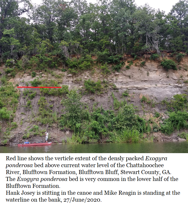
The Blufftown Formation underlies the unnamed, Cusseta equivalent formation in western Georgia and, presumably, it also grades laterally into the lower part of the Gaillard Formation. But the equivalence of both the unnamed, Cusseta-equivalent formation and the Blufftown with kaolinitic Gaillard formation is still hypothetical because the physical lithofacies changes have not yet been demonstrated and confirmed. The single greatest problem in the above assumed stratigraphic relationships is the lack of any regional discontinuity or lithofacies change within the Gaillard Formation that could be interpreted as an upper and lower Gaillard, that are correlative with the unnamed, Cusseta-equivalent formation and the Blufftown Formation. However that may be, the Blufftown is a distinctive, finely sandy and very argillaceous and clayey formation in Georgia and has been correlated in the past with the Mooreville Chalk of Alabama. The Blufftown has been identified as far downdip as Sumter County in the Danville Ferry core, and as far east as Pulaski County in the Arrowhead core; but there is no subsurface control to trace the Blufftown any farther east or downdip to the south in Georgia.
The Gaillard Formation
(Abandoning the Term Buffalo Creek Formation)
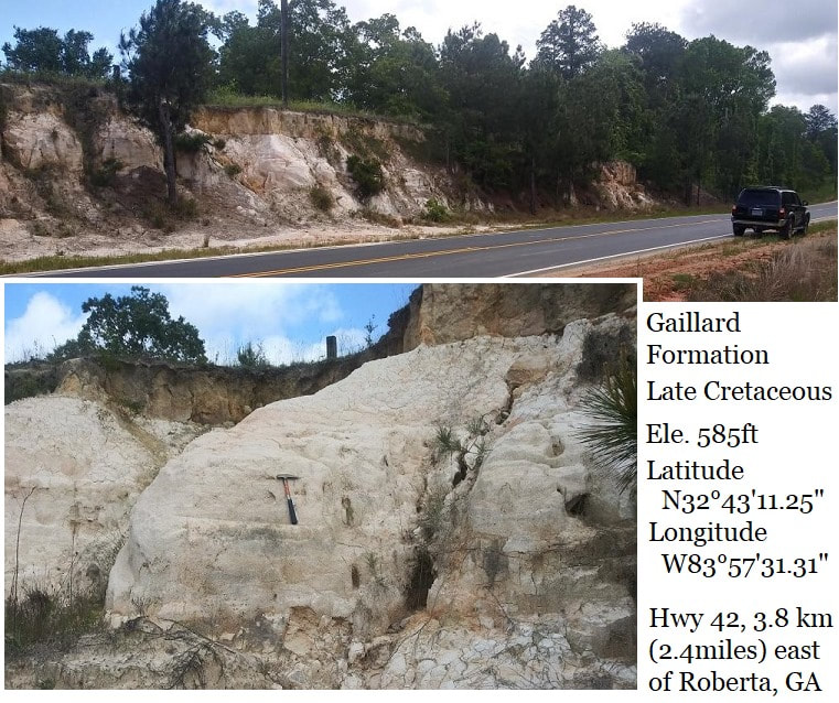
The Gaillard Formation is the principal soft kaolin Formation in the Georgia Coastal Plain. The main kaolin-bearing lenses are at the top of the formation; none of the available GGS cores have penetrated thick, mineable kaolin lenses below the top of the formation. Only two core logs in my possession, both from Georgia Kaolin Company cores, contain both the upper minable kaolin and the underlying Gaillard sands. Sam Pickering originally described the Gaillard Formation as the Buffalo Creek Formation and described it as occurring to basement. However, there are two formations beneath the Gaillard in the kaolin mining district: the underlying Pio Nino Formation and the Cape Fear Formation. Huddlestun in 1991 cautioned that the Buffalo Creek formation did not occur to basement and that the Codes of Stratigraphic Nomenclature should be followed wherever possible and not confusing. In addition, the underlying sand lithofacies of the proposed Buffalo Creek formation (the dominant lithology of the formation) is not exposed in kaolin pits or in outcrops in the kaolin mining districts. Huddlestun proposed, on the other hand, that Pickering’s Buffalo Creek should be restricted to the mineable kaolin as the Buffalo Creek Member of the Gaillard Formation because the soft kaolin is essentially what Pickering was describing for the Buffalo Creek formation. Additionally, stratigraphic members do not necessarily have to be continuous and mappable (even though this adjustment to member status is also contrary to the Code). However, the geologists in the kaolin mining industry still use the term Buffalo Creek in the original sense. As a result, I would suggest abandoning the name Buffalo Creek altogether because the name is confusing and contrary to Code usage.
The Middendorf Formation of South Carolina is stratigraphically equivalent to the Gaillard Formation. The lithologies of the two formations are similar but so are the lithologies of the Marshallville similar to the lithologies of the Gaillard and Middendorf. There have not been sufficient stratigraphic studies to show that the lithologies between the Middendorf and Gaillard are similar enough for the two formations to have one name at this time. Discouraging such an effort is the distance between the two type localities, the Gaillard being in west central Georgia near the Flint River and the Middendorf being in eastern South Carolina, in Chesterfield County.
In Georgia, the Gaillard Formation extends eastward from Taylor County, west of the Flint River, to the Savannah River in Richmond and Burke Counties. In southern Burke County the lower part of the Gaillard appears to be grading into a marine unit that would be the Black Creek Formation of South Carolina. At least, what may be Black Creek Formation is certainly not the unnamed Cusseta-equivalent formation of western Georgia. In addition, immediately across the Savannah River from southernmost Burke County, the Gaillard Formation has mostly graded downdip into the Black Creek Formation. The lithofacies change from the Gaillard into the Black Creek should be accomplished in northern Screven County. Somewhere between Laurens County and Burke/Screven Counties, on the basis of the above discussion, the unnamed Cusseta-equivalent formation and the Blufftown should grade laterally into the Black Creek Formation of the southern Atlantic Coastal Plain.
The Eutaw Formation
The Eutaw Formation underlies the Blufftown Formation and crops out in the Columbus area of Georgia. However, the Eutaw has not been penetrated by any of the GGS cores in that area. The Eutaw is a shoreface formation and its offshore, shelf bottom lithofacies is an undiscovered stratigraphic unit at the current time. However, the Eutaw grades updip in the Columbus area into the Pio Nino Formation, a distinctive formation of the Oconee Group.
The Eutaw Formation underlies the Blufftown Formation and crops out in the Columbus area of Georgia. However, the Eutaw has not been penetrated by any of the GGS cores in that area. The Eutaw is a shoreface formation and its offshore, shelf bottom lithofacies is an undiscovered stratigraphic unit at the current time. However, the Eutaw grades updip in the Columbus area into the Pio Nino Formation, a distinctive formation of the Oconee Group.
The Pio Nono Formation
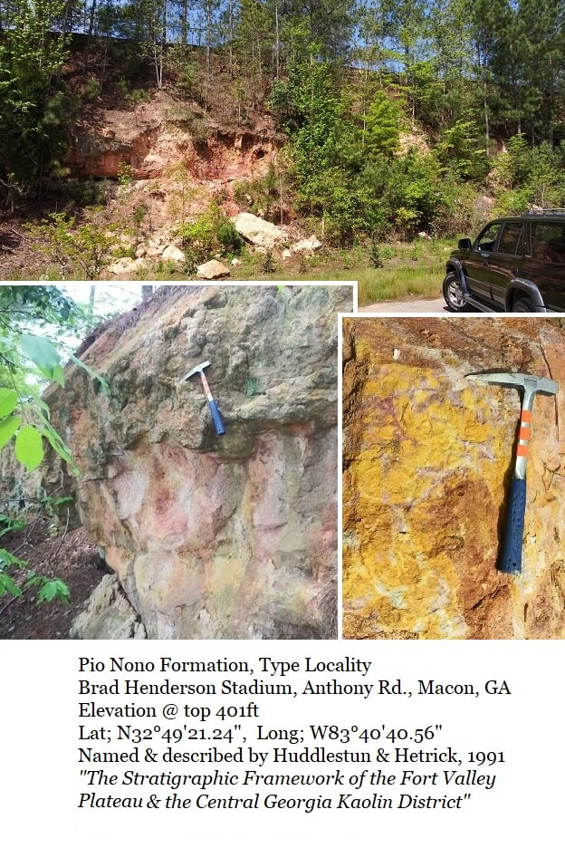
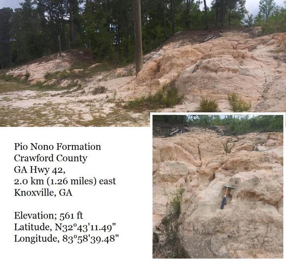
The Pio Nino is widespread in the Fall Line area of the west-central and central Coastal Plain of Georgia and directly overlies crystalline basement at the Fall line, at least from the vicinity of Junction City, where it is mined for sand, to the vicinity of Jones County in the east. East of Jones County, the Pio Nino Formation appears to be overlapped by younger formations and its updip limits occur in the subsurface. In the Bath core in southern Richmond County, the Gaillard Formation directly overlies phyllite basement, the Pio Nono being absent. So far, the Pio Nino Formation is not known to occur in Richmond County but is 173 feet thick in the Millers Pond core in Burke County, not far from McBean, Georgia. It appears that somewhere in the vicinity of McBean Creek, both the Pio Nino Formation and the underlying Cape Fear Formation appear suddenly and both thicken very rapidly. In several downdip cores across Georgia, it appears that the Pio Nino Formation is beginning to grade laterally and transition downdip into a marine, sandy formation. However, the core locations are too far updip to determine the nature of this downdip, coastal or marine stratigraphic unit. As for its eastern extent, while in the type area of the Middendorf Formation, I noted a nearby roadcut that exposed Pio Nino lithology, indicating that the Pio Nino may occur in the Fall Line area across South Carolina.
The Pio Nino is widespread in the Fall Line area of the west-central and central Coastal Plain of Georgia and directly overlies crystalline basement at the Fall line, at least from the vicinity of Junction City, where it is mined for sand, to the vicinity of Jones County in the east. East of Jones County, the Pio Nino Formation appears to be overlapped by younger formations and its updip limits occur in the subsurface. In the Bath core in southern Richmond County, the Gaillard Formation directly overlies phyllite basement, the Pio Nono being absent. So far, the Pio Nino Formation is not known to occur in Richmond County but is 173 feet thick in the Millers Pond core in Burke County, not far from McBean, Georgia. It appears that somewhere in the vicinity of McBean Creek, both the Pio Nino Formation and the underlying Cape Fear Formation appear suddenly and both thicken very rapidly. In several downdip cores across Georgia, it appears that the Pio Nino Formation is beginning to grade laterally and transition downdip into a marine, sandy formation. However, the core locations are too far updip to determine the nature of this downdip, coastal or marine stratigraphic unit. As for its eastern extent, while in the type area of the Middendorf Formation, I noted a nearby roadcut that exposed Pio Nino lithology, indicating that the Pio Nino may occur in the Fall Line area across South Carolina.
The Cape Fear Formation
The Cape Fear Formation is one of the most distinctive formations in the southeastern Coastal Plain. It consists of a stack of thin to very thick bedded, fining upward sequences, some of which are truncated. The fining upward sequences of the Cape Fear Formation are exceptionally thin compared to the other formations of the Oconee Group, of which the Cape Fear is a subdivision. The Cape Fear is a formation of the southern Atlantic Coastal Plain and the name is taken from the Cape Fear River in North Carolina. In Georgia, it is the basal formation in the Coastal Plain where it occurs, and its known western extent in Georgia is the Warner Robins area and the Elberta core in Houston County. The Cape Fear Formation is overlapped by younger formations and is not exposed in outcrop, therefore it is not present at the Fall Line. It probably occurs in a relatively narrow band and appears to begin grading downdip into another formation (possibly the Atkinson Formation of southern Georgia and Florida) in the Arrowhead core in Pulaski County. It also probably grades westward into the Oconee-like formation in the Columbus/Phenix City, Alabama area that has been called Tuscaloosa.
The Cape Fear Formation is one of the most distinctive formations in the southeastern Coastal Plain. It consists of a stack of thin to very thick bedded, fining upward sequences, some of which are truncated. The fining upward sequences of the Cape Fear Formation are exceptionally thin compared to the other formations of the Oconee Group, of which the Cape Fear is a subdivision. The Cape Fear is a formation of the southern Atlantic Coastal Plain and the name is taken from the Cape Fear River in North Carolina. In Georgia, it is the basal formation in the Coastal Plain where it occurs, and its known western extent in Georgia is the Warner Robins area and the Elberta core in Houston County. The Cape Fear Formation is overlapped by younger formations and is not exposed in outcrop, therefore it is not present at the Fall Line. It probably occurs in a relatively narrow band and appears to begin grading downdip into another formation (possibly the Atkinson Formation of southern Georgia and Florida) in the Arrowhead core in Pulaski County. It also probably grades westward into the Oconee-like formation in the Columbus/Phenix City, Alabama area that has been called Tuscaloosa.
Gulf Trough & Suwannee Strait
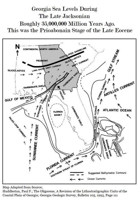
There are two areas in Georgia that contain formations not present elsewhere: the Gulf Trough and the Suwannee Strait. Some of the Gulf Trough formations have been described, and some with new names, by Huddlestun in 1993. These include Claibornian limestones, lower and upper Jacksonian limestones, the lower Oligocene, Vicksburgian Ochlockonee Formation with the Pridgen Limestone Member, the Wolf Pit Dolostone, and the Okapilco Limestone. All these units, named and unnamed, are restricted to the depths of the Gulf Trough. The formations appear to be trough, channel-fill; deposited after the Suwannee Current had subsided during the Oligocene, allowing carbonate detrital sediment to accumulate. The Bridgeboro Limestone in Georgia is associated with the Gulf Trough but occurs only on its upper, northern and southern flanks. The presence of the Bridgeboro does not appear to be associated with the Gulf Trough in western Florida or southern Alabama.
There are two areas in Georgia that contain formations not present elsewhere: the Gulf Trough and the Suwannee Strait. Some of the Gulf Trough formations have been described, and some with new names, by Huddlestun in 1993. These include Claibornian limestones, lower and upper Jacksonian limestones, the lower Oligocene, Vicksburgian Ochlockonee Formation with the Pridgen Limestone Member, the Wolf Pit Dolostone, and the Okapilco Limestone. All these units, named and unnamed, are restricted to the depths of the Gulf Trough. The formations appear to be trough, channel-fill; deposited after the Suwannee Current had subsided during the Oligocene, allowing carbonate detrital sediment to accumulate. The Bridgeboro Limestone in Georgia is associated with the Gulf Trough but occurs only on its upper, northern and southern flanks. The presence of the Bridgeboro does not appear to be associated with the Gulf Trough in western Florida or southern Alabama.
The Suwannee Current was also active during the Late Cretaceous (Navarroan, Danian and earliest Tertiary, early Midwayan, Clayton deposition). The thickest channel filling in the Suwannee Strait was during the late Paleocene, roughly Nanafalia and Tuscahoma deposition) but probably continued into the Early Eocene and possibly the early part of the Middle Eocene. The Suwannee Channel was apparently filled completely by the Late Eocene because the Ocala limestones are present in the area without any known lithology or thickness change. The only source known to me concerning the nature of the Suwannee channel-fill deposits is Herrick’s 1961, GGS well logs bulletin. The lithology of the lower part of the limestone channel fill appears to be very similar to that of the Gulf Trough channel-fill, the Ochlockonee Formation.
