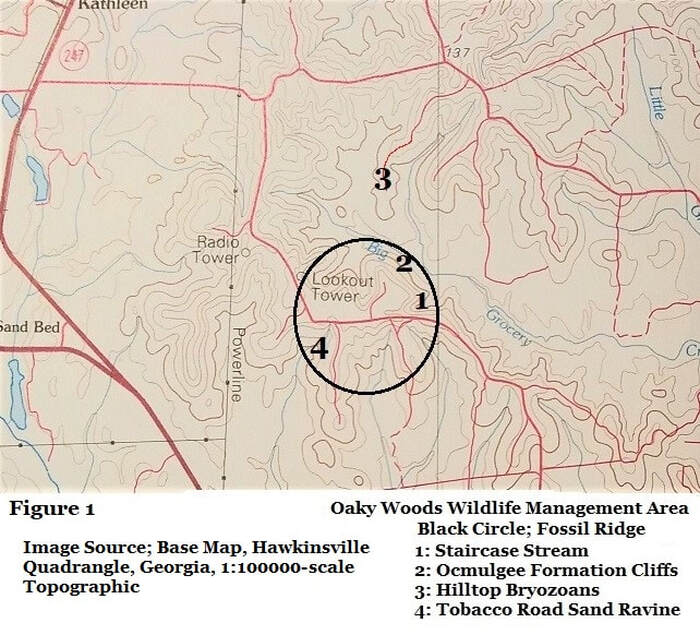
14N; Fossil Ridge
A Stratigraphic Study of
Oaky Woods
Wildlife Management Area
By
Thomas Thurman
GeorgiasFossils.com
Post Created
13/December/2019
Abstract
Previously unreported, research accessible, state protected outcrops of fossiliferous Early Oligocene residuum, Ocmulgee Formation, Tobacco Road Sand and variable facies of the Twiggs Clay Member of the Dry Branch Formation, occur at Fossil Ridge in Oaky Woods Wildlife Management Area. These, and multiple historical reports, confirm the Latest Eocene age of the Ocmulgee Formation & Tobacco Road Sand.
Previously unreported, research accessible, state protected outcrops of fossiliferous Early Oligocene residuum, Ocmulgee Formation, Tobacco Road Sand and variable facies of the Twiggs Clay Member of the Dry Branch Formation, occur at Fossil Ridge in Oaky Woods Wildlife Management Area. These, and multiple historical reports, confirm the Latest Eocene age of the Ocmulgee Formation & Tobacco Road Sand.
Introduction; Fossil Ridge
Fossil Ridge in Houston County’s Oaky Woods Wildlife Management Area holds fossils from just before and just after the Eocene/Oligocene Extinction Event, 33.9 million years ago (mya). Most of these have not been scientifically described since 1916 nor properly assigned to modern nomenclature. “Fossil Ridge” is an unofficial term coined for this paper. Also present as the oldest local sediments is the Twiggs Clay Member of the Dry Branch Formation deposited 34.35 mya.
By Georgia law it is illegal to remove fossils or artifacts from Wildlife Management Areas without written permission from the Commissioner’s Office of the Georgia Department of Natural Resources. Collection by photography only, please. It is also requested by GA DNR that visitors possess a Land Pass, Hunting or Fishing License when using state WMAs.
Oligocene Material
Fossil Ridge is capped by a wealth of post-extinction Early Oligocene residuum as boulders and dornicks both in the forest soil and often in low, man-made mounds. These mounds were reportedly created during agricultural field clearing more than a century ago. The boulders and dornicks are frequently highly fossiliferous with superb preservation. They were assigned as Oligocene Undifferentiated Residuum (1) but no Late Oligocene material has ever been reported.
Fossil Ridge is capped by a wealth of post-extinction Early Oligocene residuum as boulders and dornicks both in the forest soil and often in low, man-made mounds. These mounds were reportedly created during agricultural field clearing more than a century ago. The boulders and dornicks are frequently highly fossiliferous with superb preservation. They were assigned as Oligocene Undifferentiated Residuum (1) but no Late Oligocene material has ever been reported.
1916 Research & Later Omissions.
In 1916 Assistant State Geologist J. E. Brantly described the known limestones and marls of Georgia’s Coastal Plain in Bulletin 21 of the Georgia Geologic Survey (2). Part II of the work was a breakdown by county. His Houston County section is by far the largest of his report at 23 pages and includes most of the outcrops reported here. Huddlestun, Hetrick (3,4) and Horwath (5) were apparently unaware of the limestones within Oaky Woods. However, Huddlestun and Hetrick (3,4) did report on an outcrop of the cherty Tobacco Road Sand in a ravine on the southwest side of Fossil Ridge, which Brantly omitted in 1916 as it was not limestone.
In 1986 Huddlestun & Hetrick named and described the Ocmulgee Formation. (4) On 22/November/2015 Huddlestun confirmed that the low cliffs in Oaky Woods were of the Ocmulgee Formation and on 12/Oct/2019 Huddlestun confirmed that the Hilltop Bryozoan exposure was also Ocmulgee Formation. Prior to this, the only known large exposed facies of Ocmulgee Formation were Taylor Bluff along the Ocmulgee River.
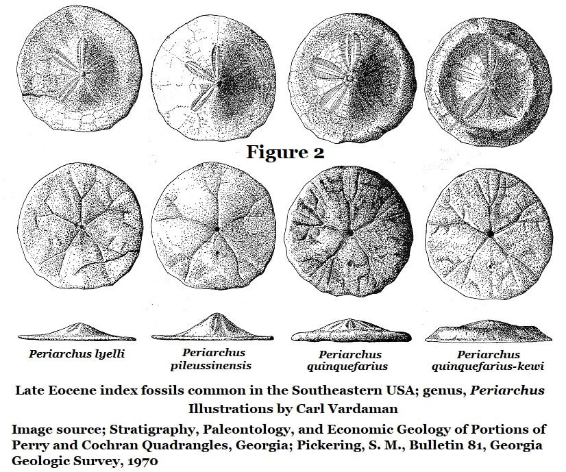
The herein reviewed Tobacco Road Sand and Ocmulgee Formation facies in Oaky Woods contain echinoids of the genus Periarchus which is restricted to the Middle and Late Eocene, the genus found extinction at the close of the Eocene and does not occur in the Oligocene. The species Periarchus lyelli has a Middle Eocene occurrence is Alabama’s Gosport Sand and equivalents. (18)
The Tobacco Road Sand
In 1978 Paul F. Huddlestun & John H. Hetrick introduced the Late Eocene Tobacco Road Sand Formation (3) and dated it to the Latest Eocene by correlating it to the Cooper Marl (later re-assigned as the Ocmulgee Formation). They reported an outcrop of the Tobacco Road Sand in an Oaky Woods “steep” which is referred to here as the Tobacco Road Sand Ravine. There Huddlestun and Hetrick correctly recorded the presence of the Late Eocene index fossils Periarchus quinquefarius and Periarchus pileussinensis (18) however some minor corrections are necessary to their 1978 observations.
In 1978 Paul F. Huddlestun & John H. Hetrick introduced the Late Eocene Tobacco Road Sand Formation (3) and dated it to the Latest Eocene by correlating it to the Cooper Marl (later re-assigned as the Ocmulgee Formation). They reported an outcrop of the Tobacco Road Sand in an Oaky Woods “steep” which is referred to here as the Tobacco Road Sand Ravine. There Huddlestun and Hetrick correctly recorded the presence of the Late Eocene index fossils Periarchus quinquefarius and Periarchus pileussinensis (18) however some minor corrections are necessary to their 1978 observations.
Staircase Stream
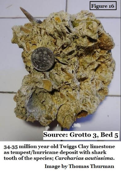
Staircase Stream (another unofficial named assigned by this report), is an erosional rain fed feature roughly 200 meters (218 yards) long while descending 45 meters (50 yards) through a series of 4 modest waterfalls forming three grottos and limestone steps. The surrounding terrain is heavily folded which makes for moderately rugged hiking terrain. Interestingly, Bed 5 of Grotto 3 described in the following pages is a fossil-rich shell-bed in the Twiggs Clay Member of the Dry Branch Formation interpreted as a tempest or hurricane deposit, by Huddlestun (2019), which occurred approximately 34.35 mya.
Staircase Stream (another unofficial named assigned by this report), is an erosional rain fed feature roughly 200 meters (218 yards) long while descending 45 meters (50 yards) through a series of 4 modest waterfalls forming three grottos and limestone steps. The surrounding terrain is heavily folded which makes for moderately rugged hiking terrain. Interestingly, Bed 5 of Grotto 3 described in the following pages is a fossil-rich shell-bed in the Twiggs Clay Member of the Dry Branch Formation interpreted as a tempest or hurricane deposit, by Huddlestun (2019), which occurred approximately 34.35 mya.
Ocmulgee Formation Cliffs
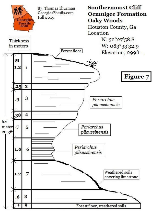
The Ocmulgee Formation is exposed on Fossil Ridge as a series of cliffs in a location roughly .8 kilometer (half a mile) north of Staircase Stream. These cliffs stand roughly 6 meters (20ft) tall off the floor of the forested basin. As the type locality for The Ocmulgee Formation is Taylor’s Bluff, an inaccessible cliff face along the Ocmulgee River, the Oaky Woods exposures described on these pages represent the largest accessible reference localities.
The Ocmulgee Formation is exposed on Fossil Ridge as a series of cliffs in a location roughly .8 kilometer (half a mile) north of Staircase Stream. These cliffs stand roughly 6 meters (20ft) tall off the floor of the forested basin. As the type locality for The Ocmulgee Formation is Taylor’s Bluff, an inaccessible cliff face along the Ocmulgee River, the Oaky Woods exposures described on these pages represent the largest accessible reference localities.
Hilltop Bryozoans
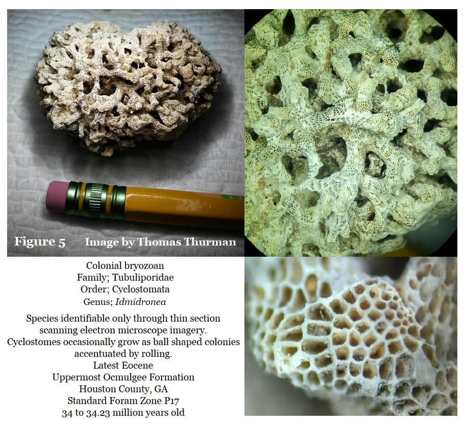
On separate ridge on the northside of Oaky Woods there’s another natural outcrop of the Ocmulgee Formation where rare, whole colonial bryozoans occur in the loose calcareous sand of the roadbed. The bryozoan colonies range from golf ball to fist sized and vary dramatically in the amount of in-fill from calcareous sediments.
On separate ridge on the northside of Oaky Woods there’s another natural outcrop of the Ocmulgee Formation where rare, whole colonial bryozoans occur in the loose calcareous sand of the roadbed. The bryozoan colonies range from golf ball to fist sized and vary dramatically in the amount of in-fill from calcareous sediments.
Age of the Sediments; Howarth 1990
In 1990 Robert M. Horwath submitted his master’s thesis paper Late Eocene and Early Oligocene Calcareous Nannofossils And Search for Microtektites From Central Georgia to the University of Georgia with Vernon J. Hurst as his advisor (5). The paper was unpublished beyond UGA.
As one of many parts of this project Horwath took 16 samples vertically down the Ocmulgee Formation and Twiggs Clay of Taylor’s Bluff. To quote part Horwath’s Abstract:
“Based on the absence of Discoaster barbadiensis and Discoaster saipanensis and the coexistence of Isthmolithus recurvus and Cyclococcolithus formosa, the Ocmulgee Formation is placed in zone NP21 which spans from the Late Eocene into the Early Oligocene.”
On the surface Horwath’s findings seem to challenge the age of the Ocmulgee Formation and this unpublished paper had surprisingly far reaching impacts. The abstract doesn’t seem to consider previous research which Hurst, his advisor, would have certainly been aware of. The tragic impact of Horwath’s paper was nearly 30 years of professional doubt over the well-established age of the Ocmulgee Formation and Tobacco Road Sand.
For instance; in a March 1999 paper over Georgia’s tektites by Edward Albin at Fernbank Science Center the Tobacco Road Sand is referred to as an Oligocene deposit. Albin is an astronomer advised by UGA geologists studying meteorites and tektites. The paper was presented at the 30th Annual Lunar and Planetary Science Conference in Texas; (14)
“…In addition to these georgiaites, a tektite find on the Oligocene Tobacco Road Sand, in Twiggs County, was reported by (Hal) Povenmire.”
Hal Povenmire’s report of a tektite from the Tobacco Road Sand dates to 1985. The formation and is comprised of river borne terrestrial sands. The tektite was very likely a secondary deposit weathered out of slightly older sediments.
To quote a separate, 1997 report from Albin (16):
“…Since all georgiaites are found on deposits younger than the age of the tektites, they must have been reworked from an older source formation...”
Lastly, in 2018 a collaborative research paper announcing Late Eocene Ocmulgee Formation and Tobacco Road Sand outcrops in Oaky Woods was rejected during the peer review process of a regional geologic journal on the grounds that questions remained over age of the Ocmulgee Formation. Research suggests that Horwath’s unpublished 1990 paper (5) is the source of doubts over the age of the Ocmulgee Formation at Taylor’s Bluff.
However, reading further into the paper’s text seems to clarify Howarth’s position on the age of the Ocmulgee Formation beyond his abstract’s statement. This is a wonderful reminder that a paper’s abstract isn’t necessarily its science. Under the heading Biostratigraphical Zonations of Georgia (5, pg.48) Horwath correctly states;
“The last appearance of D. barbadiensis and D. saipanensis has traditionally marked the Eocene-Oligocene boundary based calcareous nannofossils. However, as mentioned previously, it is now known that this event slightly predates Eocene-Oligocene as defined by planktonic foraminifera. The Ocmulgee Formation correlates with the Shubuta of Alabama.”
The Shubuta Clay is a Latest Eocene deposit in Alabama.
This passage clearly shows that Horwath placed the Ocmulgee Formation in the latest Eocene. This leaves the issue of Howarth’s abstract. The abstract page of Horwath’s paper states in parenthesis; “Under the Direction of Vernon J. Hurst”. Thus, it would seem that Hurst bears a large share of responsibility in a 30- year-old error over dating the Ocmulgee Formation as Oligocene.
The Ocmulgee Formation is NOT an Oligocene deposit.
Correcting the age of the Ocmulgee Formation
In correcting the age of the Ocmulgee Formation & Tobacco Road Sand we are mindful that the International Stratigraphic Chart sets the Eocene/Oligocene horizon at 33.9 (+or-0.1) mya. In a personal communication, Ryan Weber, the president of Paleo-data Inc, reports the fossil Cycloccolithus formosa has been reassigned as Ericsonia formosa and Paleo-Data places it’s extinction date at 32.92 mya or the very top of NP21. As far as the fossil Isthmolithus recurves, Weber states: (17)
“The fossil I. recurvus is such a pretty fossil and easily identified, but it is generally accepted to be paleo-environmentally sensitive and probably diachronous.”
Seemingly, I. recurvus has no value in dating sediments.
In 1969 W. H. Blow (6) reported the planktonic foraminifera Hantkenina alabamensis from the Cooper Marl (Ocmulgee Formation). Paleo-Data places its extinction at 33.89 mya.
In 1970 Sam Pickering (8) reported the presence of benthic foraminifera Marginulina cocoaensis in the Cooper Marl (Ocmulgee Formation). Paleo-Data records its extinction at 34.00 mya which is firmly within the Latest Eocene.
In Oaky Woods multiple species of the echinoid genus Periarchus unquestionably occur in both the Ocmulgee Formation and Tobacco Road Sand even to the uppermost beds. The genus Periarchus has never been reported in the Oligocene.
The presence of the echinoid genus Periarchus, the forams Hantkenina alabamensis and Marginulina cocoaensis, the calcareous nannofossil Ericsonia formosa would all seem to confirm the Ocmulgee Formation and Tobacco Road Sand as Latest Eocene beyond any reasonable doubt.
Tobacco Road Sand Ravine; Historical
In 1978 Huddlestun & Hetrick reported the Oaky Wood’s ravine outcrop as the western most fossiliferous sediments of the Tobacco Road Sand (3) at Latitude N32°27'29.55" by Longitude W083°34'5.44".
Fossils dominantly occur as silicified Periarchus sand dollars, often in slabs. The entire outcrop is deeply stained by iron oxidation secondary to deposition. The color and chert content of the 33.9 million year old Tobacco Road Sand in Oaky Woods is a relatively recent change in the deposits which probably occurred between 5 and 3 mya, as explained by Huddlestun & Hetrick in 1978 (3):
“During late Neogene (Tertiary) time, incision of the drainage basins to elevations below the base of the soft and permeable Tobacco Road Sand exposed the formation to vadose (underground water above the water table) conditions and, consequently, to oxidation and chemical leaching. As a result of this weathering, the patchy calcareous beds were replaced by chert and the glauconite in the sand was oxidized and leached, being replaced by hydrated ferric oxides (oxidized iron), resulting in the deep-red color and sporadic chert that is typical of the severely leached Tobacco Road Sand.”
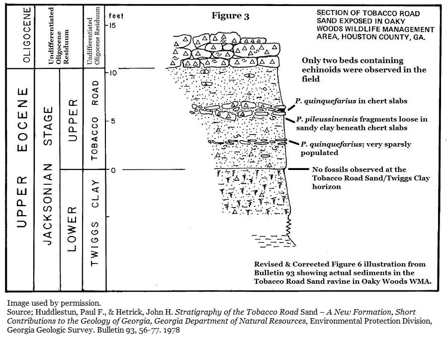
The 1978 report further states that three distinct beds of Periarchus echinoids occur with each bed separated by cohesive clayey sand devoid of fossils. In 1978 Periarchus quinquefarius was recorded in the uppermost bed, Periarchus pileussinensis was recorded in the lowermost bed at the contact of the underlying Twiggs Clay, and a possible Periarchus intermediate species was reported occupying the center bed. The 1978 report identified this overlying material as Suwannee Residuum (3), this was later revised to Undifferentiated Oligocene Residuum. The 1986 report (1) incorrectly states that the Tobacco Road Sand is overlain by the informal Shellstone Creek Beds.
Tobacco Road Sand Ravine, Recent Observation
As seen in Figure 3, the Tobacco Road Sand ravine is overlain with abundant Undifferentiated Oligocene Residuum containing Early Oligocene fossils as both boulders and dornicks. As the adapted figure below shows, only two distinct fossil beds were observed within the ravine’s Tobacco Road Sand. There’s an upper and lower bed separated by a meter of fossil barren sandy clay. Periarchus quinquefarius was observed in both fossil beds. Beneath the lower fossil bed is another span of fossil barren sandy clay and then contact with the Twiggs Clay. The Twiggs Clay/Tobacco Road Sand contact is devoid of fossils wherever contact can be observed in the ravine. Huddlestun furthermore reported the Shellstone Creek Beds in two additional locations, neither of which could be confirmed by modern field observations, therefore the nomenclature of Shellstone Creek Beds is abandoned.
As seen in Figure 3, the Tobacco Road Sand ravine is overlain with abundant Undifferentiated Oligocene Residuum containing Early Oligocene fossils as both boulders and dornicks. As the adapted figure below shows, only two distinct fossil beds were observed within the ravine’s Tobacco Road Sand. There’s an upper and lower bed separated by a meter of fossil barren sandy clay. Periarchus quinquefarius was observed in both fossil beds. Beneath the lower fossil bed is another span of fossil barren sandy clay and then contact with the Twiggs Clay. The Twiggs Clay/Tobacco Road Sand contact is devoid of fossils wherever contact can be observed in the ravine. Huddlestun furthermore reported the Shellstone Creek Beds in two additional locations, neither of which could be confirmed by modern field observations, therefore the nomenclature of Shellstone Creek Beds is abandoned.
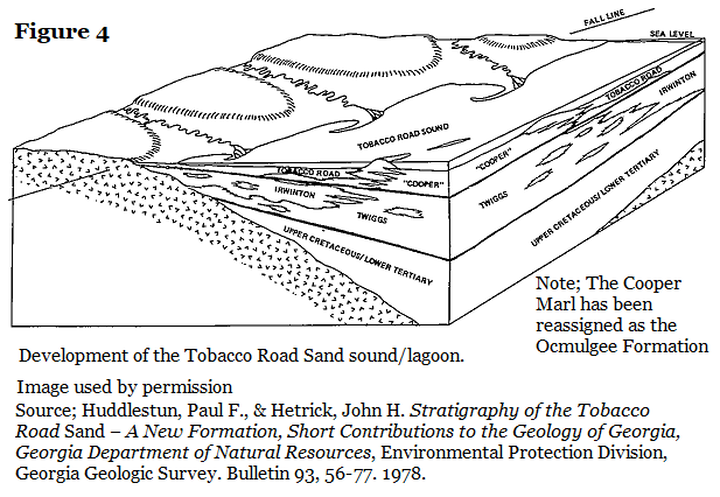
Sound or Lagoon Environment
To quote Huddlestun & Hetrick’s 1978 report; (3)
“It is postulated in this study that the Tobacco Road Sand represents an open sound or lagoon facies of the uppermost Eocene deposits in Georgia and South Carolina. If this is correct, then the latest Eocene sound must have been separated from the open ocean by barrier islands….”
Of course, Huddlestun and Hetrick were unaware of the additional Tobacco Road Sand ourcrops in Staircase Stream, nor were they aware of the additional Ocmulgee Formation outcrops in Oaky Woods.
As seen in Figure 4, Huddlestun and Hetrick predicted evidence would emerge for barrier islands in the lithology of the Tobacco Road Sand and Ocmulgee Formation. Fossil Ridge, which was likely an island during the high sea level stands of the Latest Eocene, seems to fulfill their prediction as the southwest flanks of the weathered ridge reveal Tobacco Road Sand facies and the northeast flanks reveal Ocmulgee Formation cliffs.
Results
Formation Access
Observing the Late Eocene fossils of Oaky Woods will generally require cross-county hiking, in some cases this will mean crossing folded, rugged terrain. With any luck this will help protect the outcrops. A reminder that it is illegal to remove fossils without written permission from the Commissioner’s Office of the Georgia Department of Natural Resources.
Hilltop Bryozoans, Ocmulgee Formation
The hilltop bryozoan locality is a 1.86km (1.16miles) venture down Bait Barrell Road on the Northside of Oaky Woods. It is unlikely that you’ll be able to drive the whole length as there are several deeply rutted mud holes which rarely dry out. Access will probably require hiking at least half the distance along a rough access road, but this is not a strenuous hike. Co-ordinates to the location; Latitude N32°28'33.3" by W083°33'40.2".
Sometimes superb golf ball to fist sized bryozoan colonies as seen in Figure 5, Order; Cyclostama, genus; Idmidronea were observed in the loose sandy soil, even in the roadbed. Several of these delicate samples are pristine, with most pores nearly free of sediments while other are clogged with fine grained calcareous sand. The bed of bryozoans seems maybe a meter thick and is underlain by clay-rich, lightly sandy limestone. Under magnification, this limestone displays a light content of fine-grained quartz sand. Hank Josey observed a single shark tooth from the species Abdounia enniskilleni in the bryozoan bed. Loose fragments of the echinoid Periarchus pileussinensis (18) were additionally observed in the matrix.
Low Cliffs, Ocmulgee Formation
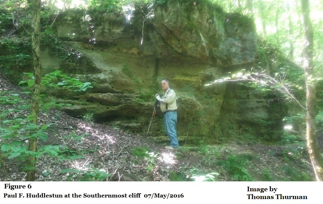
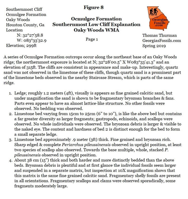
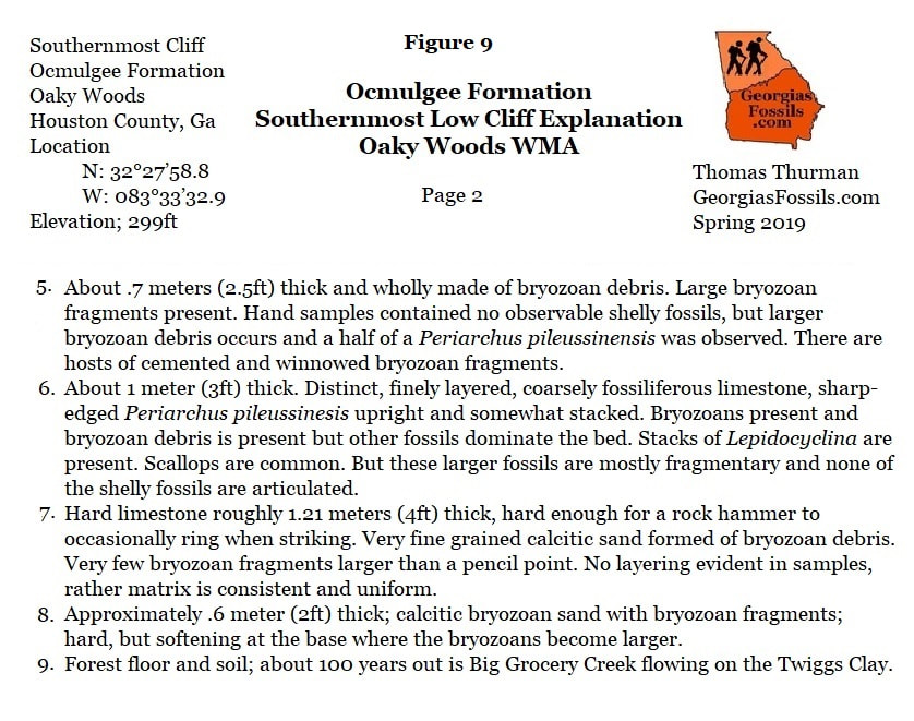
The northeast base of Fossil Ridge is marked by a series of low cliffs resting on the basin plain of Oaky Woods. The northernmost cliff occurs at Latitude N32°28’00.5 by Longitude W083°33’41.3. The Southernmost cliff, see below in Figure 6, occurs at Latitude N32°27’58.8 by Longitude W083°33’32.9.
Big Grocery Creek is about 30 to 50 meters beyond the base of the cliffs across the basin plain and appears to flow directly over the Twiggs Clay member of the Dry Branch Formation.
The cliffs are limestone, re-acting vigorously to acid, and are generally fossiliferous. There are at least five individual cliffs stretching northward each is subtly different in appearance though the limestone is generally consistent. Between the cliffs is erosional slump where the Ocmulgee Formation limestone has weathered almost away and been replaced with dark, rich soil. Frequently there are narrow drainage channels in the slump which will can yield some of the best quality, loose Periarchus pileussinensis sand dollars, often whole, wonderfully preserved and occasional lightly encrusted with bryozoan debris.
Staircase Stream
Staircase Stream begins modestly just north of Oaky Woods Access Road on the eastern fork of Jungle Fowl Patch Rd, which is little more than two worn tire paths. The co-ordinates for the stream head; Latitude; N32°27’35.1 by Longitude; W083°33’29.9W. At these co-ordinates you’ll see shallow ditches leading off to your left (east) and quickly deepening. In about 25 meters (80 feet) you’ll come to the ledge which forms the fall of Grotto 1. Over roughly 200 meters (218 yards) the stream will descend 45 meters or (50 yards) through a series of 4 modest waterfalls forming three grottos and the limestone staircase.
Staircase Stream begins modestly just north of Oaky Woods Access Road on the eastern fork of Jungle Fowl Patch Rd, which is little more than two worn tire paths. The co-ordinates for the stream head; Latitude; N32°27’35.1 by Longitude; W083°33’29.9W. At these co-ordinates you’ll see shallow ditches leading off to your left (east) and quickly deepening. In about 25 meters (80 feet) you’ll come to the ledge which forms the fall of Grotto 1. Over roughly 200 meters (218 yards) the stream will descend 45 meters or (50 yards) through a series of 4 modest waterfalls forming three grottos and the limestone staircase.
Grotto 1
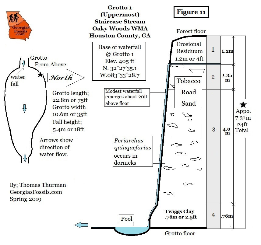
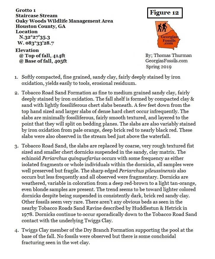
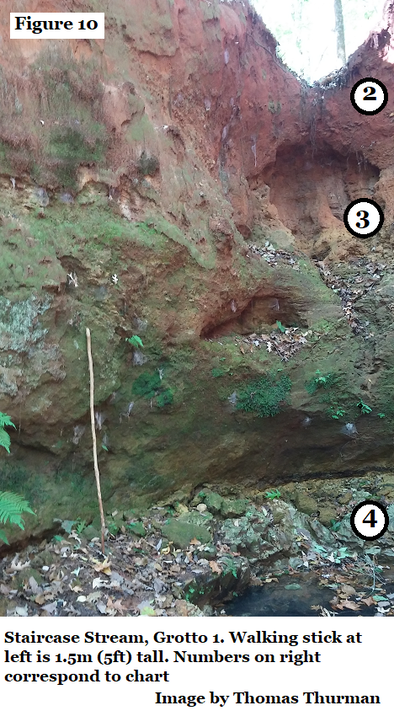
Grotto 1 (figure 10) is the deepest, largest grotto and requires a scramble down rough terrain to reach the grotto floor, you’ll likely end up with wet feet if you walk all the way up to pool typically beneath the fall. High up on the north wall near the fall you can see bedded Tobacco Road Sand slabs as a line of rock. (Just below the 2 in figure 10.) A few feet below the top of the fall slabs stop and weathered dornicks start occurring in the Tobacco Road Sand, however if you look closely in the grotto walls partial and frequently whole Periarchus sand dollars continue to occur but they are typically very fragile.
The Twiggs Clay Member of the Dry Branch Formation occurs as a .76m (2.5ft) bed at the base of the fall.
Pickering’s research on the Twiggs Clay is worth considering again as an old error that the Twiggs Clay is volcanic is origin has been recently re-introduced in the popular literature by authors unfamiliar with Coastal Plain sediments.
In 1970 Sam Pickering, reported;
“Cooke (1943), LeGrand (1962), and King (1962) stated that the Twiggs Clay is a bentonite or a weathered volcanic ash… Foraminifer tests, which are abundant in the sediment, are generally remarkably well preserved. The writer finds it most difficult to believe that the sediment was once a volcanic ash embedding consistently abundant benthonic foraminifers or that the ash could have weathered so completely as to destroy any glass and volcanic minerals and leave the delicate hyaline foraminifer tests intact and shiny… Numerous samples of Twiggs Clay from many localities were washed, screened, and examined by the author for microfossils; no glass shards were observed. In the writer's opinion, the Twiggs Clay was precipitated as colloidal particles formed by the action of saltwater on normal terrestrial clay minerals.”
Figure 11 is the section showing Grotto 1’s wall, Figure 12 is the section explanation.
Grotto 2
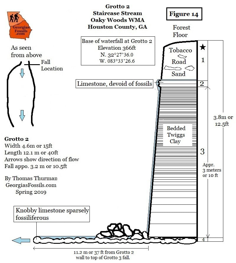
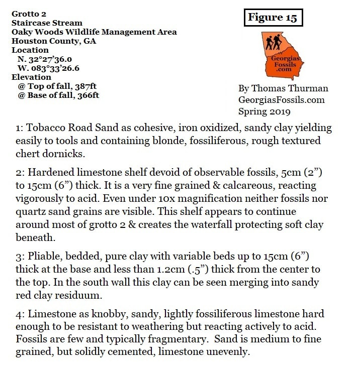
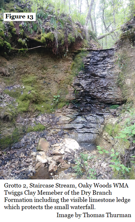
Grotto 2 is formed completely by the Twiggs Clay member of the Dray Branch Formation (figure 13). When standing on top of the fall at Grotto 2 notice that the stream banks on either side are weathered Tobacco Road Sand with suspended fossil-rich dornicks. There is a limestone ledge beneath your feet which forms a shelf for the fall.
Entering Grotto 2 from above is very difficult, it’s easier to continue downstream to Grotto 3, then climb the Grotto 3 fall back up to enter Grotto 2. The Grotto 3 fall isn’t a difficult climb.
The small Grotto 2 is floored by a knobby, sparsely fossiliferous limestone variant of the Twiggs Clay which extends all the way to the top of Grott0 3. The Grotto 2 waterfall is approximately 3 meters tall. Fossils were not observed in the walls of the grotto.
Sam Pickering described the condition which created beds of pure Twiggs Clay in 1970: (8)
“The clay is thick-bedded and indicative of quiet, low, energy, bottom conditions with rapid sedimentation. Such conditions do not favor prolific bottom life.”
Local contemporary conditions changed again because as mentioned, the floor of Grotto 2 is a hardened, knobby limestone bed stretching all the way to the shelf forming Grotto 3’s fall.
Grotto 3
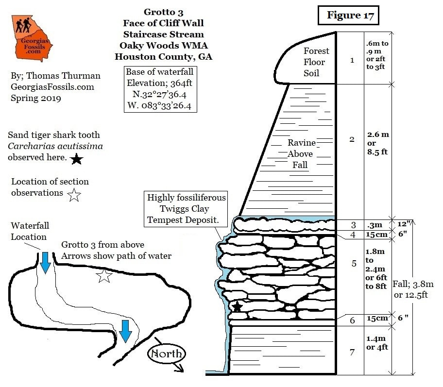
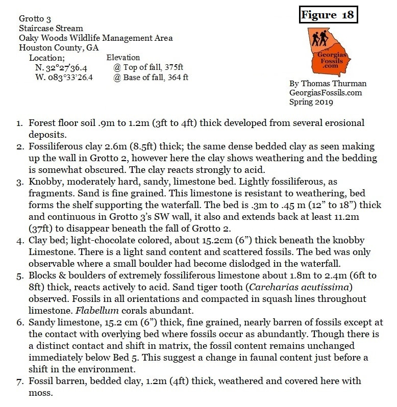
In the section of figure 17 the top of the Grotto 3 fall is shown at Bed 3 where the stream flows across the knobby limestone bed which formed the floor of Grotto 2.
Grotto 3 is the most complex of Staircase Stream but all of the beds are variations on the Twiggs Clay. Bed 5 is richest in fossils and Huddlestun interpreted this as a tempest or hurricane deposit (see figure 16).
Visible in the outcrop from Bed 4 through Bed 7 is the transitions from pure, dense clay beds to fossil rich limestone, and back to dense clay beds. A small roadside outcrop of this same limestone is visible 2.7km air miles east-southeast on the Oaky Woods loop road at Latitude N32°26'54.04" by Longitude W 083°31'54.86".
The Twiggs Clay has been dated by the presence of the foram Textularia hockleyensis which met extinction at 34.35 mya. It’s often lightly fossiliferous, even devoid of fossils and for this reason it is sometimes overlooked. However, it has historically been a source for vertebrate fossils which tend to concentrate in beds. Figure 17 is the section drawing of Grotto 3 with figure 18 being the explanation.
A partial list of additional Twiggs Clay vertebrates reported in Georgia: (Source; GeorgiasFossils.com)
The Staircase
of Staircase Stream
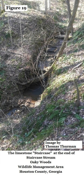
Staircase Stream ends at the Staircase, (figure 19) alternating beds of lightly fossiliferous Twiggs Clay as limestone.
It is unusual to see the Twiggs Clay in so many rapidly changing variants, it would be interesting to see research into the development of the sediments in Oaky Woods WMA, what environmental events could have triggered such variation.
Today, the nearest coastline is 239 kilometers (148 miles) to the east. The Twiggs Clay, as a fine-grained clay, has a high silt content. Silt is the last thing to settle out of terrestrial river currents when they reach the sea. When the Ocmlugee River of 34 million years ago met the coastline and discharged its sediments, the silt drifted and finally settled here. The coastline and barrier islands would have been northward.
The Twiggs Clay is an early Jacksonian formation. The Tobacco Road Sand and Ocmulgee Formation are both late Jacksonian.
The Jacksonian is defined as an episode of epeirogenic uplift (3) in the Late Priabonian which included a modest lifting of the terrain, a mild retreat in sea levels and a shift in fauna.
The Twiggs Clay was deposited before the event. The Ocmulgee Formation and Tobacco Road Sand were deposited after the event. The Tobacco Road Sand follows the contemporary coastline. In some locations its base has a 15cm (6”) bed of flat, well rounded to sub-rounded, polished, quartz pebbles which are thought to mark the transition between upper and lower Jacksonian. These pebbles may individually be to 6cm (2.5”) and they are interpreted as a beach deposit polished by surf, by wave action. While this bed of pebbles hasn’t been observed in Oaky Woods, the contact horizon between the Tobacco Road Sand and the Twiggs Clay is observable in Oaky Woods and locally marks the early/late Jacksonian horizon.
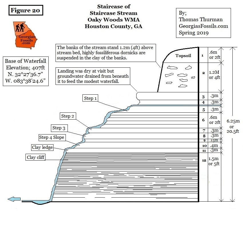
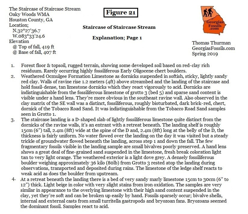
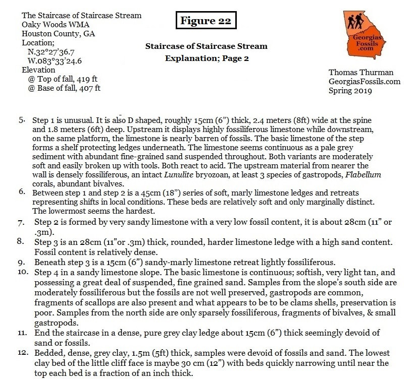
Figure 20 is the drawn section for the Staircase, figures 21 & 22 are the section explanations.
Discussion
The hope is that future researchers will come to Houston County and continue exploring and defining the various environments revealed in Oaky Wood’s stratigraphy towards revealing a natural history narrative useful educating our children and engaging all Georgians towards supporting and wisely using our Wildlife Management Areas.
Image a day when public school children from Houston and surrounding counties, elementary through high school, take a field day making observations of sand dollars, 150 miles inland, in Oaky Woods WMA.
Is there a better way to teach our kids about a changing Earth than to show them how the Earth has changed?
Acknowledgments
I have incurred many debts to professionals, professors and fellow amateurs in creating this report.
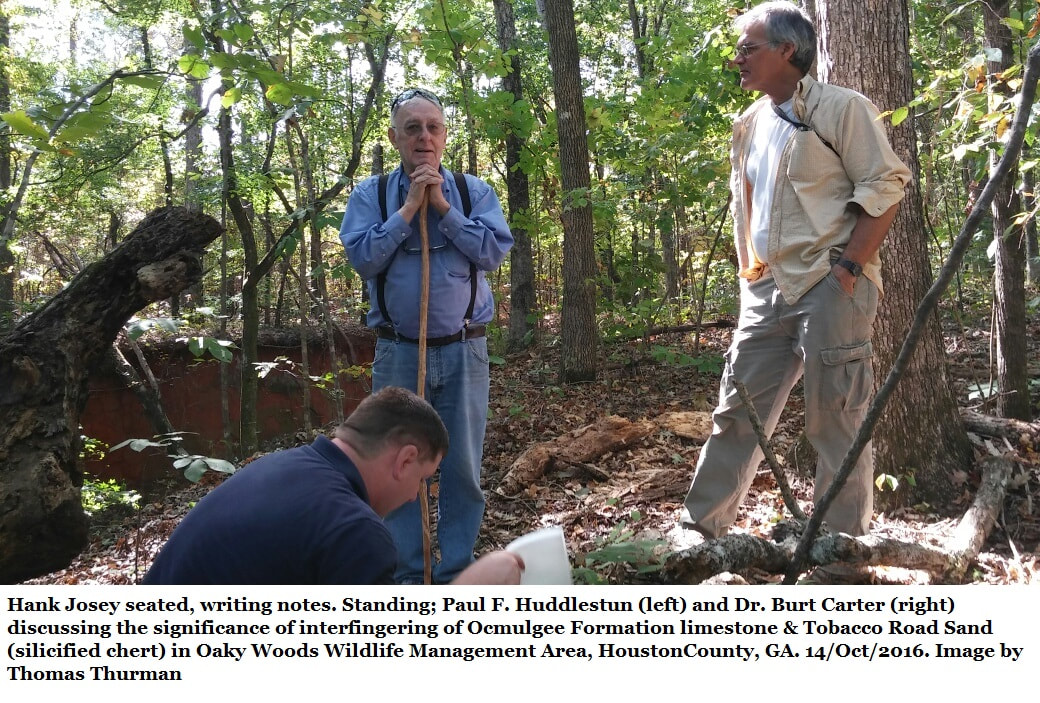
Deep gratitude is due to Hank Josey, Paul Huddlestun, Burt Carter, Roger Portell, Don Thieme, and Michael Reagin for their never-ending patience with an endless stream of questions, for the miles hiked, observations made, long conversations and endless patience while making stratigraphic and paleontological observations in Oaky Woods Wildlife Management Area. Thanks again to Hank Josey, Samantha Thurman, Michael & Gloria Hallen for the miles paddled on the Ocmulgee River to see Taylor’s Bluff.
This project would not have been possible except for the written permission, spanning three years, of Commissioner Mark Williams of the Georgia Department of Natural Resources to collect a modest amount of research samples from Oaky Woods Wildlife Management Area. Such permission was arranged by Don McGowan, Regional Operations Manager, Game Management, Wildlife Resource Division.
References
- Huddlestun, Paul F. The Oligocene, A Revision of the Lithostratigraphic Units of the Coastal Plain of Georgia. Georgia Department of Natural Resources, Environmental Protection Division, Georgia Geologic Survey, Bulletin 105. 1993.
- Brantly, J. E. A Report on the Limestones and Marls of the Coastal Plain of Georgia, Geologic Survey of Georgia, Bulletin 21. 1916
- Huddlestun, Paul F., & Hetrick, John H. Stratigraphy of the Tobacco Road Sand – A New Formation, Short Contributions to the Geology of Georgia, Georgia Department of Natural Resources, Environmental Protection Division, Georgia Geologic Survey. Bulletin 93, 56-77. 1978.
- Huddlestun, Paul F., & Hetrick, John H. Upper Eocene Stratigraphy of Central and Eastern Georgia, Georgia Department of Natural Resources, Environmental Protection Division, Bulletin 95. 1986.
- Horwath, Robert M. Late Eocene and Early Oligocene Calcareous Nannofossils And Search For Microtektites From Central Georgia. A thesis Submitted to the Graduate Faculty of the University of Georgia in Partial Fulfillment of the Requirements for the Degree Master of Science. 1990. Unpublished.
- Blow, W. H., 1969, Late Middle Eocene to Recent Planktonic Foraminiferal Biostratigraphy: Proc. Int. Conf. Planktonic Microfossils, 1st, Genevea, v. I, p. 199-422.
- Paleo-Data; PDI Paleogene Biostratigraphic Chart – Gulf Basin, USA. Updated March 2o17; https://www.paleodata.com/chart/
- Pickering, Sam M. Stratigraphy, Paleontology, and Economic Geology of Portions of Perry and Cochran Quadrangles. The Geological Survey of Georgia, Department of Mines, Mining and Geology, Bulletin 81. 1970.
- Age of Isthmolithus recurvus; Nannotax3; an authoritative guide to the biodiversity and taxonomy of coccolithophores; http://www.mikrotax.org/Nannotax3/index.php?taxon=Isthmolithus&module=Coccolithophores
- Age of Cyclococcolithus formosa; Nannotax3; an authoritative guide to the biodiversity and taxonomy of coccolithophores; http://www.mikrotax.org/Nannotax3/index.php?taxon=Coccolithus%20formosus&module=Coccolithophores
- Miller, Kenneth G., Browning, James V., Marie-Pierre Aubry, Wade, Bridgette S., Katz, Miriam E., Kulpecz, Andrew, A., & Wright, James D.; Eocene-Oligocene global climate and sea level changes: St. Stephens Quarry, Alabama. Geological Society of America Bulletin, January/February 2008.
- Miller, Kenneth G., Kominz, Michelle A., Browning, James V. Wright, James W., Mountain, Gregory S., Katz, Miriam E., Sugarman, Peter J., Cramer, Benjamin S., Christie-Blick, Micholas, Pekar, Stephen F.; The Phanerozoic Record of Global Sea-Level Change. Science, Vol. 310, 25 Nov 2005
- International Stratigraphic Chart; International Commission on Stratigraphy; 2019
- Albin, E.F.; Regional Stratigraphic Correlation of North American Tektites; 30th Annual Lunar and Planetary Science Conference, March 15-29, 1999, Houston, TX, abstract no. 1357.
- Albin, E.F. & Wampler, J.M.; New Potassium Argon Dates for and the Upper Eocene Dry Branch Formation (Twiggs Clay Member): Inferences About Tektite Stratigraphic occurrence; 27th Annual Lunar and Planetary Science Conference 1996
- Albin, E.F.; Redistribution of Georgia Tektites as Channel Lag Deposits, 28th Annual Lunar and Planetary Science Conference 1997
- Weber; Ryan D.; President & Biostratigrapher, Paleo-Data, Inc, Personal email; “I agree with Lucy (Edwards) that your age is somewhere between 32.92 - 34.44 Ma straddling the Oligocene-Eocene boundary; based on the observation of C. formosa (we still put in the genus Ericsonia), and the lack of observed D. saipanensis. The fossil I. recurvus is such a pretty fossil and easily identified, but it is generally accepted to be paleo-envronmentally sensitive and probably diachronous. Has anyone observed the planktic foraminifera Hantkenina alabamensis to further refine your age to either Oligocene or Eocene?” Oct 21, 2019
- Cooke, C. Wythe; Cenozoic Echinoids of Eastern United States; Geologic Survey Professional Paper 321, U.S. Department of the Interior, USGS, 1959
